PYRTPlan Your Road Trips
Create TripCommunityMerchandise
PYRTPlan Your Road Trips
Create TripCommunityMerchandise
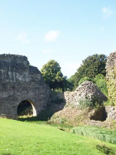
Lochmaben Castle, Dumfries and Galloway, Scotland. Photograph taken 7 September 2007.
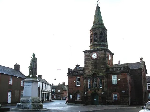
Lochmaben town centre, Dumfries and Galloway; the large building with spire is the town hall, the statue represents King Robert I (aka Robert the Bruce)
Identifier: imperialgazettscv2wils (find matches)
Title: The imperial gazetteer of Scotland; or, Dictionary of Scottish topography, compiled from the most recent authorities, and forming a complete body of Scottish geography, physical, statistical, and historical
Year: 1868 (1860s)
Authors:  Wilson, John Marius
Subjects: 
Publisher:  London A. Fullarton
Contributing Library:  National Library of Scotland
Digitizing Sponsor:  National Library of Scotland

View Book Page: Book Viewer
About This Book: Catalog Entry
View All Images: All Images From Book
Click here to view book online to see this illustration in context in a browseable online version of this book.

Text Appearing Before Image:
ndis, quhen thay wer found cowartis, or dis-comfist be thair ennymes, to give occasioun tootheris to be more bald & hardy quhen danger oe-currit. Whatever might be their character in thatearly period, they have in later ages showed, atleast, a gooddeal of humour in their depredations.Of this we have an amusing proof in the ballad ofthe Lochmaben Harper, who, having been seizedwith a strong attachment to the Lord Wardens Wanton Brown, made his way to Carlisle-castle,although blind, and so enchanted the whole com-pany, and even the minions, by the charms of hismusic, that he found means, not only to send off thewardens charger, but to persuade him, that whilehe was exerting himself to the utmost to gratify thecompany, some one had stole his own gude graymare, and thus to secure far more than the valueof all his pretended loss. Allace! allace! quo the cunning auld harper, 1 And ever allace that I cum here!In Scotland I lost a braw cowt foal; In England theyve stown my gude gray murel
Text Appearing After Image:
LOCH MABEN. & CASTLE. 
Then aye lie harped, ami nye In- earned; Sae sweet were the liarpings lie let them hear:lie was paid for the foal he had never lost, And three times ower for his glide gray mare. Additional to the castles there are, in the land-ward part of the parish, two or three other civilantiquities. Hnlf-a-mile north-west of the town,overlooking the Mill-loch, is a rising ground calledWoody or Dinwoody-castle. The summit, thoughpossessing no vestige of building, is surroundedwith a trench very distinctly marked. In a fieldsouth-west of the town is the circular trace of atower, which anciently possessed a wild fame. Itis called Coekies-field, from one John Cock, orOCoek, who resided in it, and was one of the mostrenowned freebooters of Annandale. An old ballad,still extant, details his feats of arms, dilates on hisgreat personal strength, and narrates the mannerof his death. A party of the Kings foresters, towhom he had been an intolerable pest, and whomhe had r

Note About Images

Please note that these images are extracted from scanned page images that may have been digitally enhanced for readability - coloration and appearance of these illustrations may not perfectly resemble the original work.
Photo by Original uploader was Thaf at en.wikipedia
Destinations
Home›Destinations›Lochmaben
EuropeUnited KingdomScotland

Lochmaben

Scotland, United Kingdom · Europe

About Lochmaben

Lochmaben is worth a stop: 10 minutes from Lockerbie, 55km from Bassenthwaite Lake.

Lochmaben is in Scotland, United Kingdom, with about 2,100 people. You drive on the left here. The nearest town is Lockerbie, about 6 km away.

Lochmaben (Scottish Gaelic: Loch Mhabain) is a historic market town, civil parish and former royal burgh in Dumfries and Galloway Scotland, and site of a castle. It lies approximately 42 miles (68 km) south-southwest of Edinburgh, 60 miles (97 km) southeast of Glasgow, and 4 miles (6 km) west of Lockerbie, It had a

Read more population of 2,092 in 2022. By the 12th century the Bruce family had become the local landowners and, in the 14th century, Edward I rebuilt Lochmaben Castle. It was subsequently taken by Archibald Douglas, 3rd Earl of Douglas in 1384/5 and was abandoned in the early 17th century. The town itself became a Royal Burgh in 1447.

Read more on Wikipedia

Where to Stay in Lochmaben

Compare prices across Booking.com, Airbnb, Expedia, and more. Select your dates to see availability.

Filter presets

Pick your must-haves once: provider links open pre-filtered. Each filter lists which sites it applies to.

Booking.comExpediaTripAdvisorHotels.comAgodaAirbnb

Compare before you book!

Prices can vary significantly between platforms. We recommend checking at least 2-3 sites to find the best deal for your stay in Lochmaben.

Explore the Area

Discover famous landmarks, scenic roads, and more near Lochmaben.

Loading map...
Open in Google Maps

Frequently Asked Questions

What is there to see near Lochmaben?

Within an hour or so of Lochmaben: Caerlaverock Castle (18 km), Grey Mare's Tail (33 km), Kielder Observatory (54 km), Bassenthwaite Lake (55 km).

Are there any good drives near Lochmaben?

The nearest famous roads are Whinlatter Pass (B5292), A68 Jedburgh to Edinburgh (Carter Bar) and Newlands Pass (Newlands Hause).

Where is Lochmaben?

Lochmaben is in Scotland, United Kingdom, about 6 km from Lockerbie.

Road trip

Drive to Lochmaben

Add it as a stop and the planner works out the driving, the nights and what's worth seeing on the way.

Start planning

What's nearby?

Swipe through places to go

Places within a drive of Lochmaben. Keep the ones you like and add them to your trip.

Explore now

Quick Information

Population
2,100
Continent
Europe
Country
United Kingdom
Region
Scotland
Timezone
Europe/London
Coordinates
55.1301, -3.4429

Emergency & Services

Essential numbers in United Kingdom

Police
999
Ambulance
999
Fire
999
Non-emergency police
101
Driving side
left

112 also works. NHS non-emergency medical advice: 111. National Highways breakdown assistance on motorways: 0300 123 5000.

Full driving guide for United Kingdom

Tags

EuropeUnited KingdomScotlandTown

Worth the detour from Lochmaben

7 notable places within an hour's drive.

castle

Caerlaverock Castle

A unique triangular moated castle near the Solway Firth, twice besieged and rebuilt with a Renaissance range inside.

18 km · about 20 min drive

waterfall

Grey Mare's Tail

A 60m hanging-valley waterfall beside the A708 near Moffat, with a steep path up to Loch Skeen above.

33 km · about 40 min drive

landmark

Kielder Observatory

An astronomical observatory in the darkest skies in England, running public stargazing events year-round.

54 km · about 60 min drive

natural wonder

Bassenthwaite Lake

Strictly the only body of water in the National Park called a 'lake', lying beneath Skiddaw and known for its ospreys.

55 km · about 65 min drive

ancient ruins

Birdoswald Roman Fort

A Hadrian's Wall fort above the Irthing gorge, with the longest continuous stretch of surviving wall alongside it.

56 km · about 65 min drive

famous road

Whinlatter Pass (B5292)

The forested pass between Braithwaite and Lorton, England's only true mountain forest road, gentler than its Lakeland neighbours.

60 km · about 70 min drive

natural wonder

Kielder Water

The largest artificial lake in northern Europe by capacity, ringed by a 26-mile lakeside way through Kielder Forest.

60 km · about 70 min drive

Driving roads near Lochmaben

16 named roads, passes and coastal drives within 100km.

  • 60 kmWhinlatter Pass (B5292)The forested pass between Braithwaite and Lorton, England's only true mountain forest road, gentler than its Lakeland neighbours.
  • 64 kmDerwentwaterA serene island-studded lake beside Keswick, perfect for a lakeside drive, launch cruise and the Surprise View overlook.
  • 65 kmAshness BridgeA single-arch packhorse bridge above Derwentwater, one of the most photographed spots in the Lake District with Skiddaw framed behind.
  • 65 kmCatbellsA small but shapely fell on the western shore of Derwentwater, one of the most popular first fell walks in the Lake District.
  • 66 kmNewlands PassA quiet, narrow pass through Newlands Valley with the Moss Force waterfall tumbling beside the road.
  • 66 kmNewlands Pass (Newlands Hause)A single-track climb from Braithwaite to Buttermere over 333m, with a roadside waterfall at the summit and views down to Crummock Water.

Driving in United Kingdom

Drives on
the left
Petrol
~€1.73/litre
Motorway tolls
None

When to drive here

May to September

Far northern latitude: short daylight hours outside summer make long drives harder.

Nearby Destinations

Other places to explore near Lochmaben.

Locharbriggs

🇬🇧 United Kingdom

9 km awayPop. 5,960

Dumfries

🇬🇧 United Kingdom

13 km awayPop. 46,500

Annan

🇬🇧 United Kingdom

20 km awayPop. 8,760

Eastriggs

🇬🇧 United Kingdom

23 km awayPop. 1,850

Burgh by Sands

🇬🇧 United Kingdom

34 km awayPop. 1,176

Wigton

🇬🇧 United Kingdom

38 km awayPop. 5,831

Aspatria

🇬🇧 United Kingdom

41 km awayPop. 2,454

Carlisle

🇬🇧 United Kingdom

41 km awayPop. 78,470

Plan a trip around Lochmaben

Scotland road trip planner

Your trip starts here

Plan a road trip from Lochmaben.

Pick the days, drop in the stops, and share it with whoever's coming.

Start planning
PYRT

The ultimate road trip planning platform. Discover 150,000+ destinations worldwide, plan scenic routes, and create unforgettable adventures.

Inspiration

  • Discover Trips
  • Travel Guides
  • Community

The Product

  • Calendar Planner
  • Integrations
  • How It Works
  • Collaboration Mode
  • Get the App
  • Merchandise: PYRT Supply Co.
  • Become a Creator
  • Trip Marketplace

Plan Your Trip

  • Road Trip Planner
  • Famous Routes
  • Drive Times & Distances
  • Planners by Country
  • Best Road Trip Planner App
  • Discover Road Trips
  • Events
  • Travel Guides
  • How It Works
  • My Trips
  • Community Groups

Company

  • Terms of Service
  • Privacy Policy
  • About PYRT
  • Support
  • Contact Us
  • Sign In
  • Create Account

© 2026 Plan Your Road Trips. All rights reserved.

•[email protected]
Data sources:GeoNames (CC BY 4.0)•Wikimedia Commons (CC BY-SA)•Mapbox•Photography: George Lawrence