

castle
Caerlaverock Castle
A unique triangular moated castle near the Solway Firth, twice besieged and rebuilt with a Renaissance range inside.
30 km · about 35 min drive
England, United Kingdom · Europe
Burgh by Sands is worth a stop: 15 minutes from Gretna, 32km from Bassenthwaite Lake.
Burgh by Sands is in England, United Kingdom, with about 1,200 people. You drive on the left here. The nearest town is Gretna, about 8 km away.
Burgh by Sands ( ) is a village and civil parish in the Cumberland unitary authority area of Cumbria, England, situated near the Solway Firth. The parish includes the village of Burgh by Sands along with Longburgh, Dykesfield, Boustead Hill, Moorhouse and Thurstonfield. It is notable as the site of the first recordedRead more
North African (Mauri) military unit in Roman Britain, garrisoning the frontier fort of Aballava on Hadrian's Wall in the 3rd century AD. It is also where Edward I of England died in 1307.
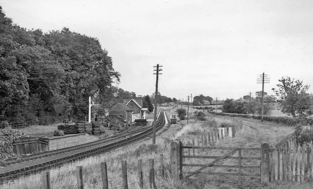
According to the 2021 census the parish had a population of 1,242. The village is about seven miles (11 km) west of Carlisle city centre. The village has a primary school, a pub and a post office. It also has a statue of Edward I at some distance to the north. Burgh was on the Carlisle Navigation canal from 1823 to 1853, after which it was served by the Port Carlisle railway, which was built on the bed of the canal, until its closure in 1932. From 1856 to 1964, railway trains operating on the Carlisle to Silloth line once again stopped at Burgh-by-Sands station.
Compare prices across Booking.com, Airbnb, Expedia, and more. Select your dates to see availability.
Pick your must-haves once: provider links open pre-filtered. Each filter lists which sites it applies to.
Compare before you book!
Prices can vary significantly between platforms. We recommend checking at least 2-3 sites to find the best deal for your stay in Burgh by Sands.
Discover famous landmarks, scenic roads, and more near Burgh by Sands.
Within an hour or so of Burgh by Sands: Caerlaverock Castle (30 km), Birdoswald Roman Fort (30 km), Bassenthwaite Lake (32 km), Castlerigg Stone Circle (36 km).
The nearest famous roads are Hartside Pass, Whinlatter Pass (B5292) and Newlands Pass (Newlands Hause).
Burgh by Sands is in England, United Kingdom, about 8 km from Gretna.
Road trip
Add it as a stop and the planner works out the driving, the nights and what's worth seeing on the way.
Start planningSwipe through places to go
Places within a drive of Burgh by Sands. Keep the ones you like and add them to your trip.
Essential numbers in United Kingdom
112 also works. NHS non-emergency medical advice: 111. National Highways breakdown assistance on motorways: 0300 123 5000.
Full driving guide for United Kingdom8 notable places within an hour's drive.
castle
A unique triangular moated castle near the Solway Firth, twice besieged and rebuilt with a Renaissance range inside.
30 km · about 35 min drive
ancient ruins
A Hadrian's Wall fort above the Irthing gorge, with the longest continuous stretch of surviving wall alongside it.
30 km · about 35 min drive
natural wonder
Strictly the only body of water in the National Park called a 'lake', lying beneath Skiddaw and known for its ospreys.
32 km · about 35 min drive
ancient ruins
A 5,000-year-old stone circle set on a fell with a 360-degree mountain panorama, free and roadside near Keswick.
36 km · about 40 min drive
mountain pass
The A686's grand sweep over the North Pennines between Penrith and Alston, climbing to 580m through wide hairpins with views across the Eden Valley to the Lake District fells. A celebrated drivers' and bikers' road.
36 km · about 40 min drive
famous road
The forested pass between Braithwaite and Lorton, England's only true mountain forest road, gentler than its Lakeland neighbours.
36 km · about 40 min drive
landmark
The main town of the northern Lake District, on the shore of Derwentwater beneath Skiddaw, with a Georgian Moot Hall at its centre.
36 km · about 40 min drive
cafe
A remote hilltop cafe at 1,904 feet on the A686 in Cumbria, one of England's highest road cafes and a bucket-list stop for bikers.
37 km · about 40 min drive
11 named roads, passes and coastal drives within 60km.
April to October
Other places to explore near Burgh by Sands.
Your trip starts here
Pick the days, drop in the stops, and share it with whoever's coming.