PYRTPlan Your Road Trips
Create TripCommunityMerchandise
PYRTPlan Your Road Trips
Create TripCommunityMerchandise
Before the year 2004, only two tropical cyclones had ever been noted in the South Atlantic Basin, and no hurricane. However, a circulation center well off the coast of southern Brazil developed tropical cyclone characteristics and continued to intensify as it moved westward. The system developed an eye and apparently reached hurricane strength on Friday, March 26, before eventually making landfall late on Saturday, March 27, 2004.
The crew of the International Space Station was notified of the cyclone and acquired excellent photographs of the storm just as it made landfall on the southern Brazilian state of Santa Catarina (the storm has been unofficially dubbed “Cyclone Catarina”). Note the clockwise circulation of Southern Hemisphere cyclones, the well-defined banding features, and the eyewall of at least a Category 1 system. The coastline is visible under the clouds in the upper left corner of the image.
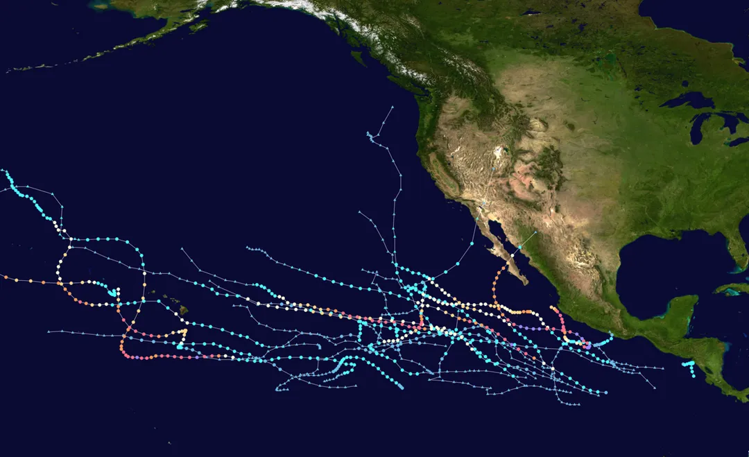
This map shows the tracks of all tropical cyclones in the 2026 Pacific hurricane season. The points show the location of each storm at 6-hour intervals. The colour represents the storm's maximum sustained wind speeds as classified in the Saffir-Simpson Hurricane Scale (see below), and the shape of the data points represent the type of the storm.
Wind history graphic from the National Weather Service of Hurricane Polo in 2026
Photo by Astronaut photograph ISS008-E-19646 was taken March 7, 2004, with a Kodak DCS760 digital camera equipped with an 50-mm lens, and is provided by the Earth Observations Laboratory, Johnson Space Center.
Destinations
Home›Destinations›Lázaro Cárdenas (El Empalme)
North AmericaMexicoMorelos

Lázaro Cárdenas (El Empalme)

Morelos, Mexico · North America

About Lázaro Cárdenas (El Empalme)

Lázaro Cárdenas (El Empalme) is worth a stop: 10 minutes from Amatlán de Quetzalcoatl, 43km from Popocatépetl.

Lázaro Cárdenas (El Empalme) is in Morelos, Mexico, with about 1,500 people. You drive on the right here. The nearest town is Amatlán de Quetzalcoatl, about 5 km away.

Where to Stay in Lázaro Cárdenas (El Empalme)

Compare prices across Booking.com, Airbnb, Expedia, and more. Select your dates to see availability.

Filter presets

Pick your must-haves once: provider links open pre-filtered. Each filter lists which sites it applies to.

Booking.comExpediaTripAdvisorHotels.comAgodaAirbnb

Compare before you book!

Prices can vary significantly between platforms. We recommend checking at least 2-3 sites to find the best deal for your stay in Lázaro Cárdenas (El Empalme).

Explore the Area

Discover famous landmarks, scenic roads, and more near Lázaro Cárdenas (El Empalme).

Loading map...
Open in Google Maps

Frequently Asked Questions

What is there to see near Lázaro Cárdenas (El Empalme)?

Within an hour or so of Lázaro Cárdenas (El Empalme): Tepoztlán (10 km), Xochimilco Floating Gardens (37 km), Popocatépetl (43 km), Paso de Cortés (44 km).

Are there any good drives near Lázaro Cárdenas (El Empalme)?

The nearest famous roads are Paso de Cortés.

Where is Lázaro Cárdenas (El Empalme)?

Lázaro Cárdenas (El Empalme) is in Morelos, Mexico, about 5 km from Amatlán de Quetzalcoatl.

Road trip

Drive to Lázaro Cárdenas (El Empalme)

Add it as a stop and the planner works out the driving, the nights and what's worth seeing on the way.

Start planning

What's nearby?

Swipe through places to go

Places within a drive of Lázaro Cárdenas (El Empalme). Keep the ones you like and add them to your trip.

Explore now

Quick Information

Population
1,507
Continent
North America
Country
Mexico
Region
Morelos
Timezone
America/Mexico_City
Coordinates
18.9322, -99.0253

Emergency & Services

Essential numbers in Mexico

Police
911
Ambulance
911
Fire
911
Driving side
right

Green Angels (free tourist roadside assistance on federal highways): 078.

Full driving guide for Mexico

Tags

North AmericaMexicoMorelosTown

Worth the detour from Lázaro Cárdenas (El Empalme)

8 notable places within an hour's drive.

landmark

Tepoztlán

A Morelos town under sheer volcanic cliffs, with a hilltop 13th-century pyramid to the pulque god reached by a steep hour's climb, a fortress-like Dominican convent, and a market known for exotic ice creams.

10 km · about 20 min drive

landmark

Xochimilco Floating Gardens

A network of ancient Aztec canals and artificial islands where colorful trajinera boats glide past floating gardens and mariachi bands.

37 km · about 45 min drive

natural wonder

Popocatépetl

An active 5,426 m stratovolcano southeast of Mexico City, visible from the Puebla highway; the Paso de Cortés road runs on its saddle.

43 km · about 50 min drive

mountain pass

Paso de Cortés

The 3,600-m saddle between the volcanoes Popocatépetl and Iztaccíhuatl, reached by a paved mountain road from Amecameca: the route Cortés marched into the Valley of Mexico in 1519.

44 km · about 50 min drive

landmark

Six Flags México

Mexico City's premier amusement park with world-class coasters and seasonal events in the south of the city.

45 km · about 50 min drive

museum

Museo Frida Kahlo (Casa Azul)

The vibrant blue house where Frida Kahlo was born, lived, and died, filled with her art, personal objects, and Diego Rivera's collection.

49 km · about 55 min drive

ancient ruins

Malinalco

Site of the Cuauhcalli, or House of Eagles: one of the very few temples in the Americas carved directly out of solid bedrock, reached by 400 steps up the Hill of the Idols above a quiet colonial town.

49 km · about 55 min drive

racetrack

Autódromo Hermanos Rodríguez

The Mexico City circuit hosting the Formula 1 Mexican Grand Prix, built around the Foro Sol stadium section.

53 km · about 60 min drive

Driving roads near Lázaro Cárdenas (El Empalme)

  • 44 kmPaso de CortésThe 3,600-m saddle between the volcanoes Popocatépetl and Iztaccíhuatl, reached by a paved mountain road from Amecameca: the route Cortés marched into the Valley of Mexico in 1519.

When to drive here

Year-round

Tropical latitude: plan around the wet season rather than temperature.

Nearby Destinations

Other places to explore near Lázaro Cárdenas (El Empalme).

Colonia Ángel Bocanegra (Adolfo López Mateos)

🇲🇽 Mexico

1 km awayPop. 1,235

Oacalco

🇲🇽 Mexico

1 km awayPop. 2,634

Colonia Obrera

🇲🇽 Mexico

1 km awayPop. 1,316

Ignacio Bastida (Santa Catarina Tlayca)

🇲🇽 Mexico

1 km awayPop. 1,164

Itzamatitlán

🇲🇽 Mexico

3 km awayPop. 1,297

Los Arcos

🇲🇽 Mexico

5 km awayPop. 5,446

Tlayacapan

🇲🇽 Mexico

5 km awayPop. 7,989

Cocoyoc

🇲🇽 Mexico

7 km awayPop. 9,663

Plan a trip around Lázaro Cárdenas (El Empalme)

North America road trip planner

Your trip starts here

Plan a road trip from Lázaro Cárdenas (El Empalme).

Pick the days, drop in the stops, and share it with whoever's coming.

Start planning
PYRT

The ultimate road trip planning platform. Discover 150,000+ destinations worldwide, plan scenic routes, and create unforgettable adventures.

Inspiration

  • Discover Trips
  • Travel Guides
  • Community

The Product

  • Calendar Planner
  • Integrations
  • How It Works
  • Collaboration Mode
  • Get the App
  • Merchandise: PYRT Supply Co.
  • Become a Creator
  • Trip Marketplace

Plan Your Trip

  • Road Trip Planner
  • Famous Routes
  • Drive Times & Distances
  • Planners by Country
  • Best Road Trip Planner App
  • Discover Road Trips
  • Events
  • Travel Guides
  • How It Works
  • My Trips
  • Community Groups

Company

  • Terms of Service
  • Privacy Policy
  • About PYRT
  • Support
  • Contact Us
  • Sign In
  • Create Account

© 2026 Plan Your Road Trips. All rights reserved.

•[email protected]
Data sources:GeoNames (CC BY 4.0)•Wikimedia Commons (CC BY-SA)•Mapbox•Photography: George Lawrence