
natural wonder
Lough Neagh
The largest freshwater lake in the British Isles at 392 square kilometres, with a famous eel fishery.
29 km · about 35 min drive
Northern Ireland, United Kingdom · Europe
Cookstown is worth a stop: 15 minutes from Moneymore, 29km from Lough Neagh.
Cookstown is in Northern Ireland, United Kingdom, with about 11,000 people. You drive on the left here. The nearest town is Moneymore, about 7 km away.
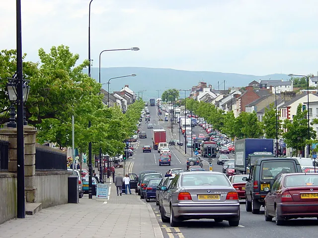
Cookstown is a market town in County Tyrone, Northern Ireland. It is the fourth-largest town in the county, with a population of 12,546 in the 2021 census. It, along with Magherafelt and Dungannon, is one of the main towns in the local government district of Mid Ulster. It was founded in the early 17th century byRead more
English colonist and ecclesiastical lawyer, Dr. Alan Cooke, during the Plantation of Ulster. The town was rebuilt in the late 18th century by the Stewart family. It was one of the main centres of the linen industry west of the River Bann, and until 1956, flax spinning, weaving, bleaching and beetling were carried out in the town. Cookstown is said to have the longest main street in Ireland, running in a straight line for 1.25 miles (2 km).
Compare prices across Booking.com, Airbnb, Expedia, and more. Select your dates to see availability.
Pick your must-haves once: provider links open pre-filtered. Each filter lists which sites it applies to.
Compare before you book!
Prices can vary significantly between platforms. We recommend checking at least 2-3 sites to find the best deal for your stay in Cookstown.
Discover famous landmarks, scenic roads, and more near Cookstown.
Within an hour or so of Cookstown: Lough Neagh (29 km), Dundrod Circuit (43 km), Titanic Belfast (54 km), Derry City Walls (54 km).
The nearest famous roads are Dundrod Circuit, The Dark Hedges and Craigantlet Hillclimb.
Cookstown is in Northern Ireland, United Kingdom, about 7 km from Moneymore.
Road trip
Add it as a stop and the planner works out the driving, the nights and what's worth seeing on the way.
Start planningSwipe through places to go
Places within a drive of Cookstown. Keep the ones you like and add them to your trip.
Essential numbers in United Kingdom
112 also works. NHS non-emergency medical advice: 111. National Highways breakdown assistance on motorways: 0300 123 5000.
Full driving guide for United Kingdom8 notable places within an hour's drive.
natural wonder
The largest freshwater lake in the British Isles at 392 square kilometres, with a famous eel fishery.
29 km · about 35 min drive
historic highway
A 11.9km loop of Northern Irish country lanes still used for the Ulster Grand Prix motorcycle races, with jumps, stone walls and hedges inches from the racing line. Open public roads the rest of the year.
43 km · about 50 min drive
museum
World-leading visitor attraction in a striking angular building on the exact spot where RMS Titanic was designed, built and launched in 1912.
54 km · about 60 min drive
landmark
The only completely intact walled city in Ireland, a 1.5km 17th-century rampart circling historic Derry.
54 km · about 60 min drive
scenic viewpoint
A basalt escarpment above Limavady with a small lake on top, used as the Dothraki grasslands in Game of Thrones.
54 km · about 60 min drive
scenic viewpoint
A viewpoint on Binevenagh above the Bishop's Road with a sculpture of the sea god Manannán Mac Lir looking out to Donegal.
57 km · about 65 min drive
photogenic
Domed 1785 rotunda perched on a 36m cliff edge above the seven-mile strand of Downhill, built by the eccentric Earl-Bishop as a library. Part of the Downhill Demesne ruins; trains pass through the cliff directly beneath it.
58 km · about 65 min drive
waterfall
The 'Queen of the Glens', with a boardwalk waterfall trail through a wooded gorge above the Antrim coast.
58 km · about 65 min drive
8 named roads, passes and coastal drives within 100km.
April to October
Other places to explore near Cookstown.
Your trip starts here
Pick the days, drop in the stops, and share it with whoever's coming.