PYRTPlan Your Road Trips
Create TripCommunityMerchandise
PYRTPlan Your Road Trips
Create TripCommunityMerchandise
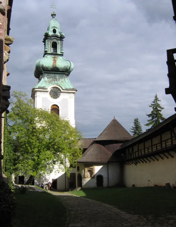
Banská Štiavnica, Starý zámokVstupná časť do areálu hradu (vonkajšie nádvorie). Kaplnka Sv. Michala sa po prestavbe stala súčasťou opevnenia
Background map of the Banská Bystrica Region, Slovakia, ready for the Geobox template, calibrated at en:Template:Geobox locator Banská Bystrica Region

Outline map of the prešov Banská Bystrica, Slovakia, ready for the Geobox template, calibrated at en:Template:Geobox locator Banská Bystrica Region
Main place of Banská Štiavnica
Photo by Juloml
Destinations
Home›Destinations›Banská Štiavnica
EuropeSlovakiaBanská Bystrica Region

Banská Štiavnica

Banská Bystrica Region, Slovakia · Europe

About Banská Štiavnica

Banská Štiavnica sits on the route: 5 minutes from Svätý Anton, 44km from Bojnice Castle.

Banská Štiavnica is in Banská Bystrica Region, Slovakia, with about 9,400 people. You drive on the right here. The nearest town is Svätý Anton, about 4 km away.

Banská Štiavnica (Slovak pronunciation: [ˈbanskaː ˈʂcɪɐʋɲitsa] ; German: Schemnitz; Hungarian: Selmecbánya (Selmec), pronounced [ˈʃɛlmɛd͡zbaːɲɒ]) is a town in central Slovakia, in the middle of an immense caldera created by the collapse of an ancient volcano. For its size, the caldera is known as the Štiavnica

Read more Mountains. Banská Štiavnica has a population of less than 10,000. The town was an important medieval mining centre. The surviving urban centre was formed during the 16th century. Because of their historical value, the town and its surroundings were proclaimed by the UNESCO to be a World Heritage Site on December 11, 1993.

Read more on Wikipedia

Where to Stay in Banská Štiavnica

Compare prices across Booking.com, Airbnb, Expedia, and more. Select your dates to see availability.

Filter presets

Pick your must-haves once: provider links open pre-filtered. Each filter lists which sites it applies to.

Booking.comExpediaTripAdvisorHotels.comAgodaAirbnb

Compare before you book!

Prices can vary significantly between platforms. We recommend checking at least 2-3 sites to find the best deal for your stay in Banská Štiavnica.

Explore the Area

Discover famous landmarks, scenic roads, and more near Banská Štiavnica.

Loading map...
Open in Google Maps

Frequently Asked Questions

What is there to see near Banská Štiavnica?

Within an hour or so of Banská Štiavnica: Špania Dolina (43 km), Bojnice Castle (44 km), Donovaly Pass (53 km).

Are there any good drives near Banská Štiavnica?

The nearest famous roads are Donovaly Pass, Certovica Pass and Droga pod Reglami, Zakopane.

Where is Banská Štiavnica?

Banská Štiavnica is in Banská Bystrica Region, Slovakia, about 4 km from Svätý Anton.

Road trip

Drive to Banská Štiavnica

Add it as a stop and the planner works out the driving, the nights and what's worth seeing on the way.

Start planning

What's nearby?

Swipe through places to go

Places within a drive of Banská Štiavnica. Keep the ones you like and add them to your trip.

Explore now

Quick Information

Population
9,426
Continent
Europe
Country
Slovakia
Region
Banská Bystrica Region
Timezone
Europe/Bratislava
Coordinates
48.4486, 18.9100

Emergency & Services

Essential numbers in Slovakia

Police
158
Ambulance
155
Fire
150
All emergencies
112
Driving side
right

Motorway vignette required. Zero alcohol limit for drivers.

Full driving guide for Slovakia

Tags

EuropeSlovakiaBanská Bystrica RegionTown

Worth the detour from Banská Štiavnica

3 notable places within an hour's drive.

landmark

Špania Dolina

A steep copper-mining village at 728 m above Banská Bystrica, mined since the Bronze Age, its miners' houses stacked around a square with a 162-step covered wooden staircase climbing to the 13th-century church.

43 km · about 50 min drive

castle

Bojnice Castle

A romantic neo-Gothic chateau of fairytale spires above a spa town, Slovakia's most-visited castle.

44 km · about 50 min drive

mountain pass

Donovaly Pass

A 960 m mountain resort saddle on Route 59 between Banska Bystrica and Ruzomberok, threading between the Low Tatras and Great Fatra with a flowing climb popular among Slovak drivers.

53 km · about 60 min drive

Driving roads near Banská Štiavnica

5 named roads, passes and coastal drives within 150km.

  • 53 kmDonovaly PassA 960 m mountain resort saddle on Route 59 between Banska Bystrica and Ruzomberok, threading between the Low Tatras and Great Fatra with a flowing climb popular among Slovak drivers.
  • 79 kmCertovica PassThe 'Devil's Pass' carries Route 72 over the spine of the Low Tatras at 1,238 m: the highest paved road pass in Slovakia, with hairpin descents on both flanks and big ridge-top views.

Driving in Slovakia

Drives on
the right
Petrol
~€1.55/litre
Motorway tolls
None
Vignette
Required, around €12 for a short-stay sticker

When to drive here

April to October

Nearby Destinations

Other places to explore near Banská Štiavnica.

Zvolen

🇸🇰 Slovakia

23 km awayPop. 39,844

Levice

🇸🇰 Slovakia

34 km awayPop. 30,556

Banská Bystrica

🇸🇰 Slovakia

37 km awayPop. 74,590

Plan a trip around Banská Štiavnica

Europe road trip planner

Your trip starts here

Plan a road trip from Banská Štiavnica.

Pick the days, drop in the stops, and share it with whoever's coming.

Start planning
PYRT

The ultimate road trip planning platform. Discover 150,000+ destinations worldwide, plan scenic routes, and create unforgettable adventures.

Inspiration

  • Discover Trips
  • Travel Guides
  • Community

The Product

  • Calendar Planner
  • Integrations
  • How It Works
  • Collaboration Mode
  • Get the App
  • Merchandise: PYRT Supply Co.
  • Become a Creator
  • Trip Marketplace

Plan Your Trip

  • Road Trip Planner
  • Famous Routes
  • Drive Times & Distances
  • Planners by Country
  • Best Road Trip Planner App
  • Discover Road Trips
  • Events
  • Travel Guides
  • How It Works
  • My Trips
  • Community Groups

Company

  • Terms of Service
  • Privacy Policy
  • About PYRT
  • Support
  • Contact Us
  • Sign In
  • Create Account

© 2026 Plan Your Road Trips. All rights reserved.

•[email protected]
Data sources:GeoNames (CC BY 4.0)•Wikimedia Commons (CC BY-SA)•Mapbox•Photography: George Lawrence