PYRTPlan Your Road Trips
Create TripCommunityMerchandise
PYRTPlan Your Road Trips
Create TripCommunityMerchandise
Despite being named after the Algonquian word for skunk, Chicago is one of America’s most thriving and spectacular cities. Spanning 22 miles along the southwest shore of Lake Michigan, the city itself holds nearly 2.9 million people and sits in the center of a metropolitan area containing more than 8 million.
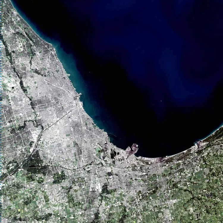
Looking at the image, some of Chicago’s famous sites can be made out. The long black line coming into the center of the city from the southwest is the Chicago Sanitary and Ship Canal. In the center of the city, just right of where the canal banks north to become the Chicago River, sits a small pier on Lake Michigan, perpendicular to the city, known as Meigs Field. Just to the left of the pier is Soldier Field. Scanning north of Meigs Field, another pier juts out onto the lake. This is Navy Pier. Though it cannot be made out in the image, the Water Tower District and the John Hancock Building sit between Navy Pier and the Chicago River. South of this area is downtown Chicago and the Sears Tower.
This simulated-color scene was acquired by the Landsat 7 Enhanced Thematic Mapper plus (ETM+) on September 14, 2001.
  

”The purpose of NASA's Earth Observatory is to provide a freely-accessible publication on the Internet where the public can obtain new satellite imagery and scientific information about our home planet. The focus is on Earth's climate and environmental change. In particular, we hope our site is useful to public media and educators. Any and all materials published on the Earth Observatory are freely available for re-publication or re-use, except where copyright is indicated. We ask that NASA's Earth Observatory be given credit for its original materials.”
The First Congregational Church Western Springs, Illinois, USA, on the National Register of Historic Sites,
Photo of Western Springs
Photo by NASA/USGS Landsat 7
Destinations
Home›Destinations›Western Springs
North AmericaUnited StatesIllinois

Western Springs

Illinois, United States · North America

About Western Springs

Western Springs works well as a base: 5 minutes from Countryside, 24km from Route 66 - Chicago Start.

Western Springs is in Illinois, United States, with about 13,000 people. You drive on the right here. The nearest town is Countryside, about 4 km away.

The Western Springs Water Tower is a museum and former water tower in Western Springs, Illinois. The water tower is considered a symbol of Western Springs by residents, and multiple businesses and local organizations have taken their names from the tower. It was added to the National Register of Historic Places on

Read more June 4, 1981.

Read more on Wikipedia

Where to Stay in Western Springs

Compare prices across Booking.com, Airbnb, Expedia, and more. Select your dates to see availability.

Filter presets

Pick your must-haves once: provider links open pre-filtered. Each filter lists which sites it applies to.

Booking.comExpediaTripAdvisorHotels.comAgodaAirbnb

Compare before you book!

Prices can vary significantly between platforms. We recommend checking at least 2-3 sites to find the best deal for your stay in Western Springs.

Explore the Area

Discover famous landmarks, scenic roads, and more near Western Springs.

Loading map...
Open in Google Maps

Frequently Asked Questions

What is there to see near Western Springs?

Within an hour or so of Western Springs: Willis Tower (Sears Tower) (23 km), Lou Mitchell's (23 km), Route 66 - Chicago Start (24 km), Art Institute of Chicago (24 km).

Are there any good drives near Western Springs?

The nearest famous roads are Route 66 - Chicago Start.

Where is Western Springs?

Western Springs is in Illinois, United States, about 4 km from Countryside.

Road trip

Drive to Western Springs

Add it as a stop and the planner works out the driving, the nights and what's worth seeing on the way.

Start planning

What's nearby?

Swipe through places to go

Places within a drive of Western Springs. Keep the ones you like and add them to your trip.

Explore now

Quick Information

Population
13,369
Continent
North America
Country
United States
Region
Illinois
Timezone
America/Chicago
Coordinates
41.8098, -87.9006

Emergency & Services

Essential numbers in United States

Police
911
Ambulance
911
Fire
911
Driving side
right

AAA roadside assistance: 1-800-222-4357. Right turn on red is legal in most states unless signed otherwise.

Full driving guide for United States

Tags

North AmericaUnited StatesIllinoisTown

Worth the detour from Western Springs

6 notable places within an hour's drive.

landmark

Willis Tower (Sears Tower)

Iconic 110-storey Chicago skyscraper with a glass-floored Skydeck, once the tallest building in the world.

23 km · about 25 min drive

cafe

Lou Mitchell's

Serving double-yolk eggs and free Milk Duds since 1923, this Chicago diner beside the start of Route 66 is the traditional first breakfast of the Mother Road journey.

23 km · about 25 min drive

66 US ROUTE

historic highway

Route 66 - Chicago Start

The 'Begin Route 66' sign on Adams Street at Michigan Avenue marks the start of the 2,448-mile Mother Road to Santa Monica: the classic photo stop before heading west.

24 km · about 25 min drive

museum

Art Institute of Chicago

One of the oldest and largest art museums in the US, renowned for its Impressionist collection and Grant Wood's American Gothic.

24 km · about 30 min drive

museum

Field Museum of Natural History

Home to Sue, the largest and most complete T. rex ever found, along with extensive anthropological and geological collections.

24 km · about 30 min drive

landmark

Shedd Aquarium

Iconic Chicago aquarium on the Lake Michigan waterfront housing over 32,000 animals from around the world.

25 km · about 30 min drive

Driving roads near Western Springs

  • 24 kmRoute 66 - Chicago StartThe 'Begin Route 66' sign on Adams Street at Michigan Avenue marks the start of the 2,448-mile Mother Road to Santa Monica: the classic photo stop before heading west.

Nearby Destinations

Other places to explore near Western Springs.

Hinsdale

🇺🇸 United States

3 km awayPop. 17,628

Clarendon Hills

🇺🇸 United States

5 km awayPop. 8,676

Westmont

🇺🇸 United States

6 km awayPop. 24,941

Summit

🇺🇸 United States

8 km awayPop. 11,389

Bellwood

🇺🇸 United States

8 km awayPop. 19,308

Berkeley

🇺🇸 United States

9 km awayPop. 5,203

Darien

🇺🇸 United States

9 km awayPop. 22,256

Maywood

🇺🇸 United States

9 km awayPop. 24,012

Plan a trip around Western Springs

North America road trip planner

Your trip starts here

Plan a road trip from Western Springs.

Pick the days, drop in the stops, and share it with whoever's coming.

Start planning
PYRT

The ultimate road trip planning platform. Discover 150,000+ destinations worldwide, plan scenic routes, and create unforgettable adventures.

Inspiration

  • Discover Trips
  • Travel Guides
  • Community

The Product

  • Calendar Planner
  • Integrations
  • How It Works
  • Collaboration Mode
  • Get the App
  • Merchandise: PYRT Supply Co.
  • Become a Creator
  • Trip Marketplace

Plan Your Trip

  • Road Trip Planner
  • Famous Routes
  • Drive Times & Distances
  • Planners by Country
  • Best Road Trip Planner App
  • Discover Road Trips
  • Events
  • Travel Guides
  • How It Works
  • My Trips
  • Community Groups

Company

  • Terms of Service
  • Privacy Policy
  • About PYRT
  • Support
  • Contact Us
  • Sign In
  • Create Account

© 2026 Plan Your Road Trips. All rights reserved.

•[email protected]
Data sources:GeoNames (CC BY 4.0)•Wikimedia Commons (CC BY-SA)•Mapbox•Photography: George Lawrence