PYRTPlan Your Road Trips
Create TripCommunityMerchandise
PYRTPlan Your Road Trips
Create TripCommunityMerchandise
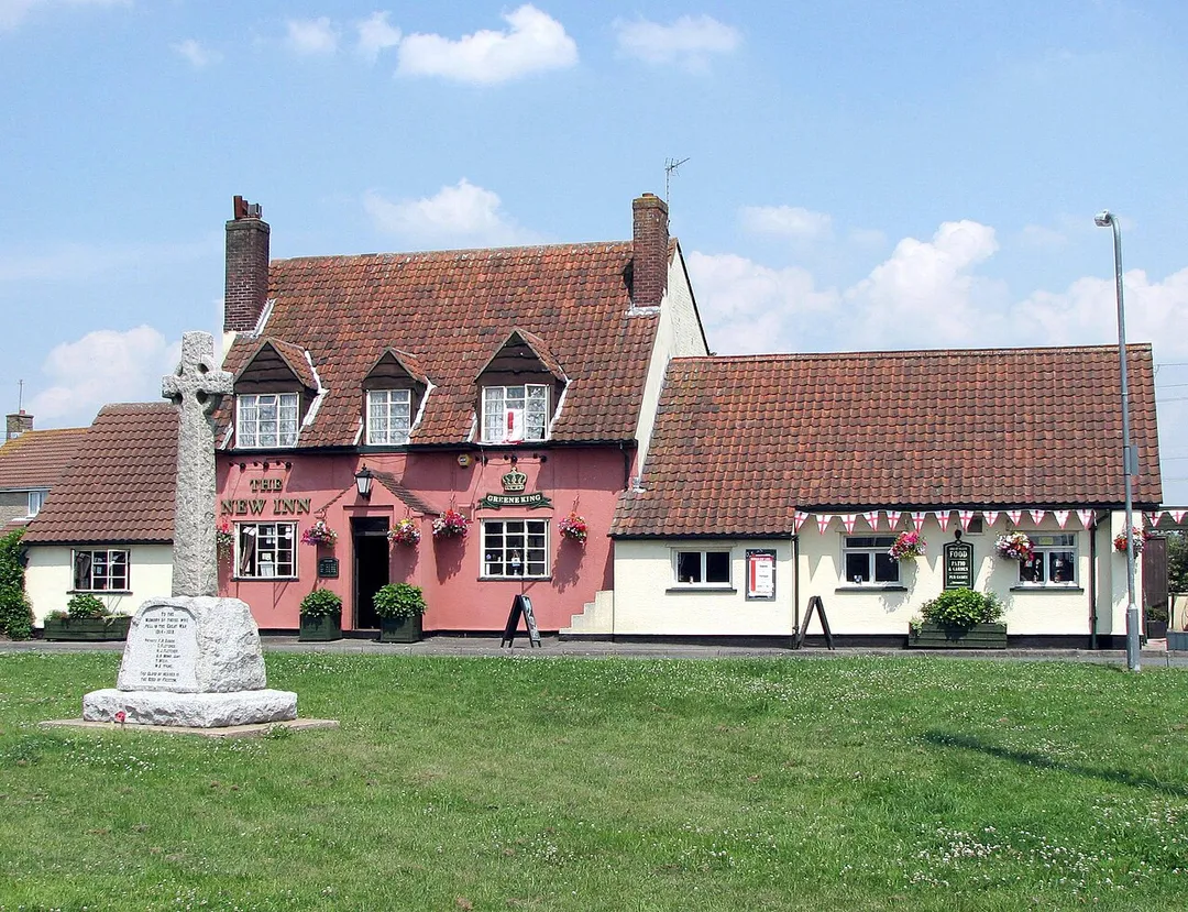
The New Inn, Westerleigh, South Gloucestershire, in south west England.

Photographed by Adrian Pingstone in July 2006 and placed in the public domain.
Photo of Westerleigh
Aerial view to horizon. Existing buildings and residences shown pictorially. Relief shown by landform drawings. Contains cadastral map of National Prohibition Park residential subdivision showing new streets, trees, lot lines, and lot numbers. Oriented with north toward the upper right. Available also through the Library of Congress Web site as a raster image. LC copy imperfect: Use-worn, darkened, fold-lined, torn in margins and at fold lines, small sections of margin missing. Includes notes, location map (inset aerial view), directory of company officers' names, and ill. of principal buildings. PM3 Acquisitions control no.: 2006-151
Photo by Arpingstone
Destinations
Home›Destinations›Westerleigh
North AmericaUnited StatesNew York

Westerleigh

New York, United States · North America

About Westerleigh

Westerleigh works well as a base: 10 minutes from Bloomfield, 11km from Statue of Liberty.

Westerleigh is in New York, United States, with about 8,900 people. You drive on the right here. The nearest town is Bloomfield, about 4 km away.

Where to Stay in Westerleigh

Compare prices across Booking.com, Airbnb, Expedia, and more. Select your dates to see availability.

Filter presets

Pick your must-haves once: provider links open pre-filtered. Each filter lists which sites it applies to.

Booking.comExpediaTripAdvisorHotels.comAgodaAirbnb

Compare before you book!

Prices can vary significantly between platforms. We recommend checking at least 2-3 sites to find the best deal for your stay in Westerleigh.

Explore the Area

Discover famous landmarks, scenic roads, and more near Westerleigh.

Loading map...
Open in Google Maps

Frequently Asked Questions

What is there to see near Westerleigh?

Within an hour or so of Westerleigh: Statue of Liberty (11 km), One World Trade Center (14 km), 9/11 Memorial & Museum (14 km), Brooklyn Bridge (15 km).

Are there any good drives near Westerleigh?

The nearest famous roads are Hawk's Nest (Route 97).

Where is Westerleigh?

Westerleigh is in New York, United States, about 4 km from Bloomfield.

Road trip

Drive to Westerleigh

Add it as a stop and the planner works out the driving, the nights and what's worth seeing on the way.

Start planning

What's nearby?

Swipe through places to go

Places within a drive of Westerleigh. Keep the ones you like and add them to your trip.

Explore now

Quick Information

Population
8,927
Continent
North America
Country
United States
Region
New York
Timezone
America/New_York
Coordinates
40.6212, -74.1318

Emergency & Services

Essential numbers in United States

Police
911
Ambulance
911
Fire
911
Driving side
right

AAA roadside assistance: 1-800-222-4357. Right turn on red is legal in most states unless signed otherwise.

Full driving guide for United States

Tags

North AmericaUnited StatesNew YorkTown

Worth the detour from Westerleigh

8 notable places within an hour's drive.

landmark

Statue of Liberty

Colossal neoclassical sculpture gifted by France in 1886, standing as a universal symbol of freedom and democracy.

11 km · about 20 min drive

landmark

One World Trade Center

Tallest building in the Western Hemisphere at 541 metres, rising from the site of the original World Trade Center.

14 km · about 25 min drive

landmark

9/11 Memorial & Museum

Tribute at the World Trade Center site featuring twin reflecting pools set in the footprints of the original towers.

14 km · about 25 min drive

landmark

Brooklyn Bridge

Landmark 1883 hybrid cable-stayed suspension bridge connecting Manhattan and Brooklyn over the East River.

15 km · about 30 min drive

restaurant

Katz's Delicatessen

Lower East Side deli open since 1888, hand-carving some 15,000 pounds of pastrami a week under fluorescent light and salami-strung ceilings. You take a paper ticket at the door and guard it.

17 km · about 20 min drive

cafe

Moto Coffee Machine

A New York motorcycle-themed specialty coffee spot where two-wheeled culture meets the city's cafe scene.

18 km · about 20 min drive

landmark

Empire State Building

Legendary 102-storey Art Deco skyscraper that defined the New York City skyline when completed in 1931.

19 km · about 20 min drive

landmark

Times Square

Dazzling commercial intersection in Midtown Manhattan known for its giant digital billboards and New Year's Eve ball drop.

20 km · about 25 min drive

Nearby Destinations

Other places to explore near Westerleigh.

Port Richmond

🇺🇸 United States

1 km awayPop. 15,470

Grymes Hill

🇺🇸 United States

3 km awayPop. 4,985

New Brighton

🇺🇸 United States

4 km awayPop. 3,421

New Springville

🇺🇸 United States

4 km awayPop. 20,756

Concord

🇺🇸 United States

4 km awayPop. 8,857

Stapleton

🇺🇸 United States

5 km awayPop. 5,365

Clifton

🇺🇸 United States

5 km awayPop. 9,519

Dongan Hills

🇺🇸 United States

5 km awayPop. 9,529

Plan a trip around Westerleigh

North America road trip planner

Your trip starts here

Plan a road trip from Westerleigh.

Pick the days, drop in the stops, and share it with whoever's coming.

Start planning
PYRT

The ultimate road trip planning platform. Discover 150,000+ destinations worldwide, plan scenic routes, and create unforgettable adventures.

Inspiration

  • Discover Trips
  • Travel Guides
  • Community

The Product

  • Calendar Planner
  • Integrations
  • How It Works
  • Collaboration Mode
  • Get the App
  • Merchandise: PYRT Supply Co.
  • Become a Creator
  • Trip Marketplace

Plan Your Trip

  • Road Trip Planner
  • Famous Routes
  • Drive Times & Distances
  • Planners by Country
  • Best Road Trip Planner App
  • Discover Road Trips
  • Events
  • Travel Guides
  • How It Works
  • My Trips
  • Community Groups

Company

  • Terms of Service
  • Privacy Policy
  • About PYRT
  • Support
  • Contact Us
  • Sign In
  • Create Account

© 2026 Plan Your Road Trips. All rights reserved.

•[email protected]
Data sources:GeoNames (CC BY 4.0)•Wikimedia Commons (CC BY-SA)•Mapbox•Photography: George Lawrence