PYRTPlan Your Road Trips
Create TripCommunityMerchandise
PYRTPlan Your Road Trips
Create TripCommunityMerchandise
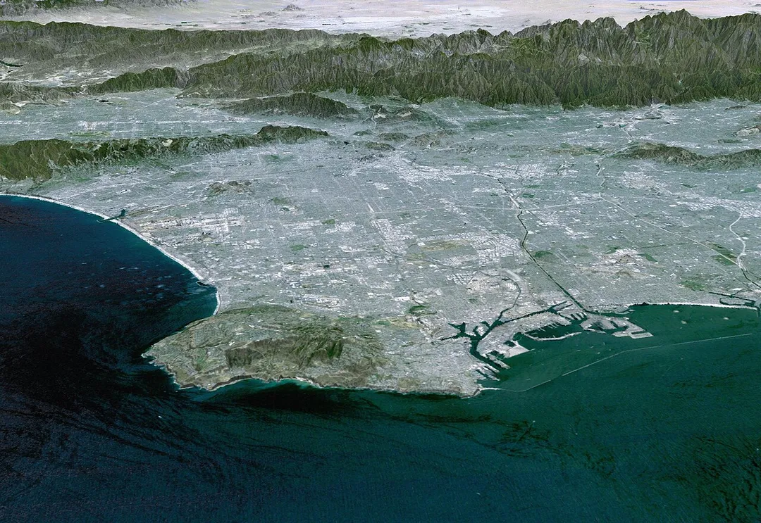
3-D Perspective image of the Los Angeles Basin from the Landsat satellite using NASA's Shuttle Radar Topography Mission (SRTM) for topography information. The vertical scale is exaggerated one and half times.
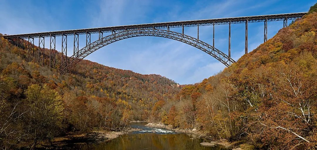
The New River Gorge Bridge in Fayetteville, West Virginia is a steel arch bridge that carries US 19 over the New River. It opened in 1977 and is the longest and highest steel arch bridge in the Western Hemisphere at 3030 ft (924 m) long and 876 ft (267 m) high. The bridge hosts Bridge Day, an annual event in which it closes to vehicles, and participants are allowed to BASE jump to the valley floor below.
Identifier: bulletinofunited309eldr (find matches)
Title: Bulletin of the United States Geological Survey--The Santa Clara Valley, Puente Hills and Los Angeles Oil Districts
Year: 1907 (1900s)
Authors:  Eldridge, George Homans Arnold, Ralph
Subjects: 
Publisher: 
Contributing Library:  Clemson University Libraries
Digitizing Sponsor:  LYRASIS Members and Sloan Foundation

View Book Page: Book Viewer
About This Book: Catalog Entry
View All Images: All Images From Book
Click here to view book online to see this illustration in context in a browseable online version of this book.

Text Appearing Before Image:
silytraced along its surface outcrop than any other stratum in theregion. Angular fragments of thin shale strew the surface of theground throughout the greater part of the distance from Lake Shoreavenue westward to a point 1^ miles southeast of Colegrove. If itwere not for this hard, flinty shale the difficulty of tracing the con-tinuity of the formations north of the central field would be greatlyincreased. Above this flinty shale band lie the soft conglomerate, heavy andthin-bedded iine-grained sandstone, and sandy and clayey shale ofthe Fernando. This formation is probably over 2,000 feet thick, onlythe lower part, however, being exposed in the central field. In thisfield the soft, thin-bedded sandstone is confined largely to the lower500 feet of the formation. This sandstone appears to be more or lesspetroliferous toward the west end of the field, and as a consequenceits outcrop is stained rusty red, purple, and pink. This coloration of U. S. GEOLOGICAL SURVE1 BULLETIN NO. 309 PL.
Text Appearing After Image:
NODULAR MIOCENE SANDSTONE AT LOS ANGELES

Note About Images

Please note that these images are extracted from scanned page images that may have been digitally enhanced for readability - coloration and appearance of these illustrations may not perfectly resemble the original work.
Photo by This image uses high-resolution digital topography data from NASA's Shuttle Radar Topography Mission (SRTM) at JPL-Caltech [1]. It is in the public domain in the United States.
Destinations
Home›Destinations›West Puente Valley
North AmericaUnited StatesCalifornia

West Puente Valley

California, United States · North America

About West Puente Valley

West Puente Valley works well as a base: 5 minutes from Baldwin Park, 19km from Wally Parks NHRA Motorsports Museum.

West Puente Valley is in California, United States, with about 23,000 people. You drive on the right here. The nearest town is Baldwin Park, about 4 km away.

West Puente Valley () is an unincorporated community and census-designated place in the San Gabriel Valley of Los Angeles County, California, United States, northwest of La Puente. The population was 22,959 at the 2020 census, up from 22,636 at the 2010 census. The community is probably named for its location related

Read more to the city of La Puente.

Read more on Wikipedia

Where to Stay in West Puente Valley

Compare prices across Booking.com, Airbnb, Expedia, and more. Select your dates to see availability.

Filter presets

Pick your must-haves once: provider links open pre-filtered. Each filter lists which sites it applies to.

Booking.comExpediaTripAdvisorHotels.comAgodaAirbnb

Compare before you book!

Prices can vary significantly between platforms. We recommend checking at least 2-3 sites to find the best deal for your stay in West Puente Valley.

Explore the Area

Discover famous landmarks, scenic roads, and more near West Puente Valley.

Loading map...
Open in Google Maps

Frequently Asked Questions

What is there to see near West Puente Valley?

Within an hour or so of West Puente Valley: Wally Parks NHRA Motorsports Museum (19 km), In-N-Out Burger Pomona Dragstrip (19 km), Knott's Berry Farm (23 km), Philippe the Original (25 km).

Are there any good drives near West Puente Valley?

The nearest famous roads are Mulholland Drive and Route 66 - Santa Monica End.

Where is West Puente Valley?

West Puente Valley is in California, United States, about 4 km from Baldwin Park.

Road trip

Drive to West Puente Valley

Add it as a stop and the planner works out the driving, the nights and what's worth seeing on the way.

Start planning

What's nearby?

Swipe through places to go

Places within a drive of West Puente Valley. Keep the ones you like and add them to your trip.

Explore now

Quick Information

Population
22,636
Continent
North America
Country
United States
Region
California
Timezone
America/Los_Angeles
Coordinates
34.0517, -117.9684

Emergency & Services

Essential numbers in United States

Police
911
Ambulance
911
Fire
911
Driving side
right

AAA roadside assistance: 1-800-222-4357. Right turn on red is legal in most states unless signed otherwise.

Full driving guide for United States

Tags

North AmericaUnited StatesCaliforniaTown

Worth the detour from West Puente Valley

8 notable places within an hour's drive.

museum

Wally Parks NHRA Motorsports Museum

Drag racing's shrine at the Pomona Fairplex, steps from the historic strip where the NHRA season starts and ends, packed with top fuel dragsters, hot rods and land-speed cars.

19 km · about 20 min drive

racetrack

In-N-Out Burger Pomona Dragstrip

The oldest continuously operating drag strip in the world, opened 1951 on the Los Angeles County Fairplex, and the traditional season opener and finale of the NHRA calendar.

19 km · about 20 min drive

landmark

Knott's Berry Farm

America's first theme park in Buena Park, California, known for its Old West Ghost Town and thrilling coasters.

23 km · about 25 min drive

restaurant

Philippe the Original

Serving French dip sandwiches since 1908 on sawdust-covered floors with communal tables and long wooden counters. One of Los Angeles's oldest restaurants and a claimant to inventing the French dip.

25 km · about 30 min drive

restaurant

Cole's Pacific Electric Buffet

Open since 1908 in the old Pacific Electric building, with a penny-tile floor, original mahogany bar and a rival claim to the French dip. A hidden speakeasy bar sits behind an unmarked door.

26 km · about 30 min drive

landmark

Disneyland Park

Walt Disney's original theme park opened in 1955, the happiest place on earth in Anaheim, California.

27 km · about 30 min drive

cafe

The Original Pantry Cafe

A downtown Los Angeles counter-and-booth diner that has served 24 hours a day since 1924 and famously has no lock on the front door. Cash-only, enormous portions, sourdough on every table.

27 km · about 30 min drive

landmark

Disney California Adventure Park

Anaheim Disney park celebrating California's culture, history, and natural beauty with Pixar and Marvel lands.

28 km · about 30 min drive

Driving roads near West Puente Valley

  • 44 kmMulholland DriveWinding road through the Santa Monica Mountains with LA city views
  • 49 kmRoute 66 - Santa Monica EndThe 'End of the Trail' sign on Santa Monica Pier marks Route 66's symbolic Pacific terminus, 2,448 miles from Chicago, beside the pier's vintage carousel and Ferris wheel.

Nearby Destinations

Other places to explore near West Puente Valley.

Valinda

🇺🇸 United States

2 km awayPop. 22,822

Avocado Heights

🇺🇸 United States

3 km awayPop. 15,411

West Covina

🇺🇸 United States

3 km awayPop. 108,484

Baldwin Park

🇺🇸 United States

4 km awayPop. 77,071

La Puente

🇺🇸 United States

4 km awayPop. 40,745

El Monte

🇺🇸 United States

6 km awayPop. 116,732

Hacienda Heights

🇺🇸 United States

7 km awayPop. 54,038

Vincent

🇺🇸 United States

7 km awayPop. 15,922

Plan a trip around West Puente Valley

North America road trip planner

Your trip starts here

Plan a road trip from West Puente Valley.

Pick the days, drop in the stops, and share it with whoever's coming.

Start planning
PYRT

The ultimate road trip planning platform. Discover 150,000+ destinations worldwide, plan scenic routes, and create unforgettable adventures.

Inspiration

  • Discover Trips
  • Travel Guides
  • Community

The Product

  • Calendar Planner
  • Integrations
  • How It Works
  • Collaboration Mode
  • Get the App
  • Merchandise: PYRT Supply Co.
  • Become a Creator
  • Trip Marketplace

Plan Your Trip

  • Road Trip Planner
  • Famous Routes
  • Drive Times & Distances
  • Planners by Country
  • Best Road Trip Planner App
  • Discover Road Trips
  • Events
  • Travel Guides
  • How It Works
  • My Trips
  • Community Groups

Company

  • Terms of Service
  • Privacy Policy
  • About PYRT
  • Support
  • Contact Us
  • Sign In
  • Create Account

© 2026 Plan Your Road Trips. All rights reserved.

•[email protected]
Data sources:GeoNames (CC BY 4.0)•Wikimedia Commons (CC BY-SA)•Mapbox•Photography: George Lawrence