
museum
Riverside Museum
Glasgow's Zaha Hadid-designed transport museum on the Clyde, packed with classic cars, a recreated cobbled street of vintage vehicles, and the tall ship Glenlee moored outside.
7 km · about 15 min drive
Scotland, United Kingdom · Europe
Thornliebank is worth a stop: 5 minutes from Newton Mearns, 37km from Loch Lomond.
Thornliebank is in Scotland, United Kingdom, with about 4,200 people. You drive on the left here. The nearest town is Newton Mearns, about 4 km away.
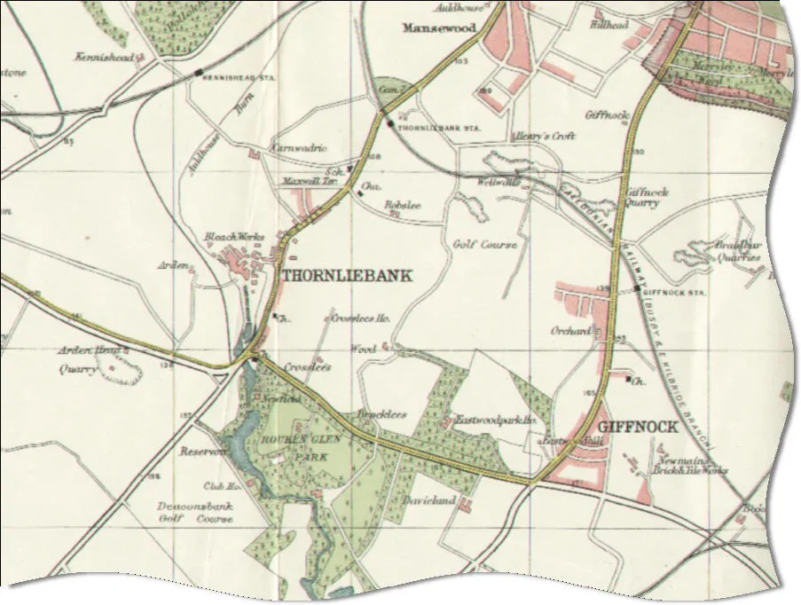
Thornliebank (Scots: Thonliebank, Scottish Gaelic: Bruach nan Dealgan) is an area of East Renfrewshire, in the west central Lowlands of Scotland. Part of the Greater Glasgow conurbation, it is located on the Auldhouse Burn about six miles (ten kilometres) south of Glasgow city centre, and just outside the city'sRead more
administrative boundaries (the closest neighbourhoods within Glasgow, to the west and north of Thornliebank, being Arden, Carnwadric, Deaconsbank, Eastwood, Jenny Lind and Mansewood). The neighbouring East Renfrewshire town of Giffnock lies directly to the east, with Rouken Glen Park to the south.
The original village was founded in the 18th century and began to develop after the opening of a printworks in 1778, and subsequently other light industry. Despite industrial decline in the 20th century, Thornliebank continued to expand due to extensive public and private housing construction. As of the 2011 Census, the area has a population of 4,051.
Compare prices across Booking.com, Airbnb, Expedia, and more. Select your dates to see availability.
Pick your must-haves once: provider links open pre-filtered. Each filter lists which sites it applies to.
Compare before you book!
Prices can vary significantly between platforms. We recommend checking at least 2-3 sites to find the best deal for your stay in Thornliebank.
Discover famous landmarks, scenic roads, and more near Thornliebank.
Within an hour or so of Thornliebank: Riverside Museum (7 km), The Oak Tree Inn (34 km), Loch Lomond (37 km), Stirling Castle (42 km).
The nearest famous roads are Electric Brae, Rest and Be Thankful (A83) and Arran Coast Road (A841).
Thornliebank is in Scotland, United Kingdom, about 4 km from Newton Mearns.
Road trip
Add it as a stop and the planner works out the driving, the nights and what's worth seeing on the way.
Start planningSwipe through places to go
Places within a drive of Thornliebank. Keep the ones you like and add them to your trip.
Essential numbers in United Kingdom
112 also works. NHS non-emergency medical advice: 111. National Highways breakdown assistance on motorways: 0300 123 5000.
Full driving guide for United Kingdom8 notable places within an hour's drive.
museum
Glasgow's Zaha Hadid-designed transport museum on the Clyde, packed with classic cars, a recreated cobbled street of vintage vehicles, and the tall ship Glenlee moored outside.
7 km · about 15 min drive
cafe
A popular stopping point on the A82 beside Loch Lomond, where road trippers heading to the Scottish Highlands pause to take in one of Scotland's most beautiful lochs.
34 km · about 40 min drive
natural wonder
Britain's largest freshwater lake by surface area, where Highland mountains meet Lowland shores in a landscape immortalised in song.
37 km · about 45 min drive
castle
One of Scotland's largest and most important castles, sitting atop Castle Hill and closely associated with Scottish independence.
42 km · about 50 min drive
landmark
Two 30-metre steel horse-head sculptures towering over the canal at Falkirk, a striking modern landmark off the M9.
42 km · about 50 min drive
landmark
An outrageous 14m stone pineapple crowns this 1761 walled-garden folly, built for the Earl of Dunmore and rated among Britain's most eccentric buildings. Free to visit, hidden down a lane near Airth.
45 km · about 50 min drive
film location
The Victorian tower commemorating William Wallace overlooks the Stirling battlefield central to Braveheart's story; the film itself shot largely in Ireland.
45 km · about 50 min drive
film location
The 14th-century keep is Castle Anthrax in Monty Python and the Holy Grail, Castle Leoch in Outlander and Winterfell in the GoT pilot.
45 km · about 50 min drive
7 named roads, passes and coastal drives within 100km.
May to September
Far northern latitude: short daylight hours outside summer make long drives harder.
Other places to explore near Thornliebank.
Your trip starts here
Pick the days, drop in the stops, and share it with whoever's coming.