PYRTPlan Your Road Trips
Create TripCommunityMerchandise
PYRTPlan Your Road Trips
Create TripCommunityMerchandise
Automobile road from Los Angeles to Redondo, 1921
Strip map of automobile routes between Los Angeles and Redondo (Beach).
Bounded by: Los Angeles (top), Cliffton (bottom & right), El Segundo (left). Due north is about 35 degrees to the left of vertical.
Other prominent locations: Exposition Park, Angeles Mesa, Hyde Park, Inglewood, Hawthorne, Southland, Lawndale, Manhattan Beach, Hermosa.
Principal features: municipalities, roads, railroads, road names, mileages, services, elevations.
Printed at bottom is "548" and "Brown". Printed at bottom, outside of map itself, is "133" and, at top, "When roads are marked red indicates paved portion, blue unpaved portion". :*On verso is notice to look for official hotels and garages and a list of 3 hotels and 3 garages. At verso bottom is "Map no. 133" and "221".


Filename: AAA-SM-005232; AAA-SM-005232v
Coverage date: 1921-02-01
Part of collection: Automobile Club of Southern California collection, 1892-1963
Type: maps; texts
Part of subcollection: Automobile Club of Southern California strip maps, 1912-1936
Publisher (of the Digital Version): University of Southern California. Libraries
Cartographer: Brown
Geographic subject (city or populated place): Los Angeles; Redondo; Cliffton; El Segundo
Repository address: 2601 South Figueroa Street, H-118, Los Angeles, CA 90007-3294, USA
Format (aacr2): map : b&w ; 27 x 10 cm.
Language: English
Rights: Automobile Club of Southern California
Repository name: Automobile Club of Southern California
Subject (adlf): roadways
Repository email: yates.morgan@aaa-calif.com
Contributing entity: Automobile Club of Southern California
Date created: 1921-02-01
Call number: SMC Box 37 (5232)
Format (aat): strip maps; cartographic material
Geographic subject (state): California
Legacy record ID: acsc-m90
Access conditions: 213-741-4486; http://www.aaa-calif.com
Creator: Automobile Club of Southern California. Touring Bureau. Route and Map Service (1344 South Figueroa Street, Los Angeles)
Subject (lcsh): Maps, Tourist
If this city had recycled more turn-of-the-last-century buildings instead of demolishing them, tourists would have a lot more reason to visit Chicago.
And maybe this city wouldn't be 700 million dollars in the hole, and having to bring dog-and-pony shows like NATO to town to "showcase our city". Between the first Daley and the second, there's not much city left to showcase. Taking NATO leaders to hear honest blues at the Maxwell Street Market? Touring the Stock Exchange, McGraw-Hill, Republic and Time-Life Buildings? The NorthWestern, LaSalle Street and Grand Central Stations? Not possible anymore.
The second Daley's last act of vandalism was tearing down practically the entire Michael Reese Hospital complex, including buildings designed by Walter Gropius, to make room for a pie-in-the-sky 2016 Olympics that we had no chance of landing once the beating death of Derrion Albert hit the headlines. 
We've torn down entire blocks of elegant turn-of-the-century homes and buildings on the south side and west sides through fast-track demolition. Indiana, Prairie and Calumet from 39th to 55th look like they were hit by an atomic bomb. Ditto Englewood and North Lawndale. No wonder this city has lost a third of its population since 1950. 

Oh well, NATO members can always gawk at these pieces of a Chicago that, thanks to short-term greed, no longer exists.
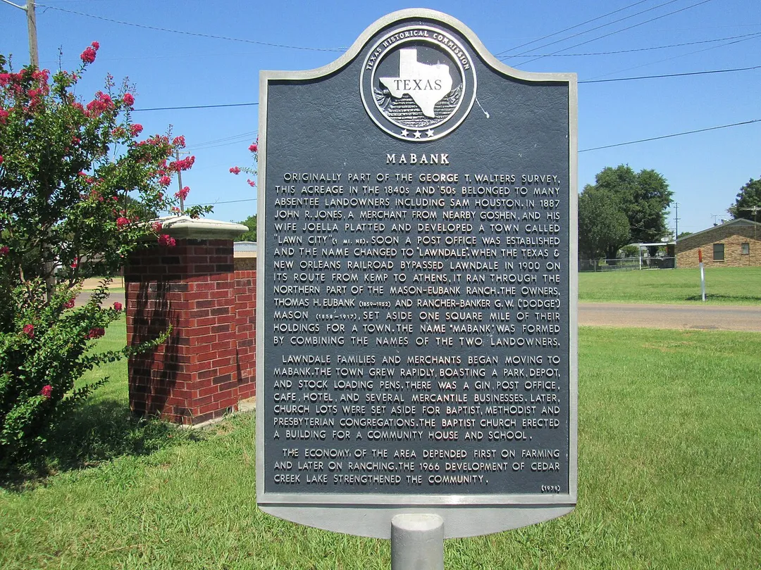
Title: Mabank
Marker No.: 8533
HMdb.org page: www.hmdb.org//marker.asp?MarkerID=96337
Address: Mabank
Latitude & Longitude: 32.369167, -96.113267
Location Description:  Marker is at the intersection of West Mason Street and West Market Street, on the left when traveling south on West Mason Street. Click for map. In the median between US BUS 175 and West Market Street. Marker is in this post office area: Mabank TX 75147, United States of America.
Year: 1979
RTHL: False
Size: 27" x 42"
Erected By: Texas Historical Commission
Marker Text:
Originally part of the George T. Walters Survey, this acreage in the 1840s and '50s belonged to many absentee landowners including Sam Houston.  In 1887 John R. Jones, a merchant from nearby Goshen, and his wife Joella platted and developed a town called "Lawn City" (1 mi. NE).  Soon a post office was established and the name changed to "Lawndale".  When the Texas & New Orleans Railroad bypassed Lawndale in 1900 on its route from Kemp to Athens, it ran through the northern part of the Mason-Eubank Ranch.  The owners, Thomas H. Eubank (1859-1952) and rancher-banker G. W. ("Dodge") Mason (1858-1917), set aside one square mile of their holdings for a town.  The name "Mabank" was formed by combining the names of the two landowners.
Lawndale families and merchants began moving to Mabank.  The town grew rapidly, boasting a park, depot, and stock loading pens.  There was a gin, post office, cafe, hotel, and several mercantile businesses.  Later, church lots were set aside for Baptist, Methodist and Presbyterian congregations.  The Baptist church erected a building for a community house and school.

The economy of the area depended first on farming and later on ranching.  The 1966 development of Cedar Creek Lake strengthened the community.
Photo by Unknown authorUnknown author
Destinations
Home›Destinations›South Lawndale
North AmericaUnited StatesIllinois

South Lawndale

Illinois, United States · North America

About South Lawndale

South Lawndale works well as a base: 10 minutes from Lower West Side, 8km from Route 66 - Chicago Start.

South Lawndale is in Illinois, United States, with about 74,000 people. You drive on the right here. The nearest town is Lower West Side, about 4 km away.

Where to Stay in South Lawndale

Compare prices across Booking.com, Airbnb, Expedia, and more. Select your dates to see availability.

Filter presets

Pick your must-haves once: provider links open pre-filtered. Each filter lists which sites it applies to.

Booking.comExpediaTripAdvisorHotels.comAgodaAirbnb

Compare before you book!

Prices can vary significantly between platforms. We recommend checking at least 2-3 sites to find the best deal for your stay in South Lawndale.

Explore the Area

Discover famous landmarks, scenic roads, and more near South Lawndale.

Loading map...
Open in Google Maps

Frequently Asked Questions

What is there to see near South Lawndale?

Within an hour or so of South Lawndale: Willis Tower (Sears Tower) (7 km), Lou Mitchell's (7 km), Route 66 - Chicago Start (8 km), Art Institute of Chicago (8 km).

Are there any good drives near South Lawndale?

The nearest famous roads are Route 66 - Chicago Start.

Where is South Lawndale?

South Lawndale is in Illinois, United States, about 4 km from Lower West Side.

Road trip

Drive to South Lawndale

Add it as a stop and the planner works out the driving, the nights and what's worth seeing on the way.

Start planning

What's nearby?

Swipe through places to go

Places within a drive of South Lawndale. Keep the ones you like and add them to your trip.

Explore now

Quick Information

Population
73,826
Continent
North America
Country
United States
Region
Illinois
Timezone
America/Chicago
Coordinates
41.8436, -87.7125

Emergency & Services

Essential numbers in United States

Police
911
Ambulance
911
Fire
911
Driving side
right

AAA roadside assistance: 1-800-222-4357. Right turn on red is legal in most states unless signed otherwise.

Full driving guide for United States

Tags

North AmericaUnited StatesIllinoisTown

Worth the detour from South Lawndale

6 notable places within an hour's drive.

landmark

Willis Tower (Sears Tower)

Iconic 110-storey Chicago skyscraper with a glass-floored Skydeck, once the tallest building in the world.

7 km · about 15 min drive

cafe

Lou Mitchell's

Serving double-yolk eggs and free Milk Duds since 1923, this Chicago diner beside the start of Route 66 is the traditional first breakfast of the Mother Road journey.

7 km · about 15 min drive

66 US ROUTE

historic highway

Route 66 - Chicago Start

The 'Begin Route 66' sign on Adams Street at Michigan Avenue marks the start of the 2,448-mile Mother Road to Santa Monica: the classic photo stop before heading west.

8 km · about 15 min drive

museum

Art Institute of Chicago

One of the oldest and largest art museums in the US, renowned for its Impressionist collection and Grant Wood's American Gothic.

8 km · about 15 min drive

museum

Field Museum of Natural History

Home to Sue, the largest and most complete T. rex ever found, along with extensive anthropological and geological collections.

8 km · about 15 min drive

landmark

Shedd Aquarium

Iconic Chicago aquarium on the Lake Michigan waterfront housing over 32,000 animals from around the world.

9 km · about 15 min drive

Driving roads near South Lawndale

  • Right hereRoute 66 - Chicago StartThe 'Begin Route 66' sign on Adams Street at Michigan Avenue marks the start of the 2,448-mile Mother Road to Santa Monica: the classic photo stop before heading west.

Nearby Destinations

Other places to explore near South Lawndale.

North Lawndale

🇺🇸 United States

2 km awayPop. 35,276

Brighton Park

🇺🇸 United States

3 km awayPop. 44,202

Cicero

🇺🇸 United States

3 km awayPop. 83,886

Lower West Side

🇺🇸 United States

4 km awayPop. 34,410

East Garfield Park

🇺🇸 United States

4 km awayPop. 20,656

Bridgeport

🇺🇸 United States

5 km awayPop. 33,878

Chicago

🇺🇸 United States

5 km awayPop. 2,664,452

Gage Park

🇺🇸 United States

6 km awayPop. 41,202

Plan a trip around South Lawndale

North America road trip planner

Your trip starts here

Plan a road trip from South Lawndale.

Pick the days, drop in the stops, and share it with whoever's coming.

Start planning
PYRT

The ultimate road trip planning platform. Discover 150,000+ destinations worldwide, plan scenic routes, and create unforgettable adventures.

Inspiration

  • Discover Trips
  • Travel Guides
  • Community

The Product

  • Calendar Planner
  • Integrations
  • How It Works
  • Collaboration Mode
  • Get the App
  • Merchandise: PYRT Supply Co.
  • Become a Creator
  • Trip Marketplace

Plan Your Trip

  • Road Trip Planner
  • Famous Routes
  • Drive Times & Distances
  • Planners by Country
  • Best Road Trip Planner App
  • Discover Road Trips
  • Events
  • Travel Guides
  • How It Works
  • My Trips
  • Community Groups

Company

  • Terms of Service
  • Privacy Policy
  • About PYRT
  • Support
  • Contact Us
  • Sign In
  • Create Account

© 2026 Plan Your Road Trips. All rights reserved.

•[email protected]
Data sources:GeoNames (CC BY 4.0)•Wikimedia Commons (CC BY-SA)•Mapbox•Photography: George Lawrence