PYRTPlan Your Road Trips
Create TripCommunityMerchandise
PYRTPlan Your Road Trips
Create TripCommunityMerchandise
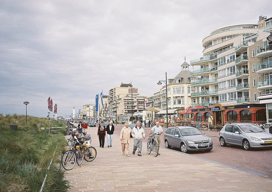
: Die Strandpromenade in Noordwijk

 : Seaside promenade in Noordwijk
 :
 : promenada nadbrzeżna
Source: own work
Date: June 2007, Noordwijk, South Holland, Netherlands
Author: Maschinenjunge
Licence: GFDL, cc-by 3.0
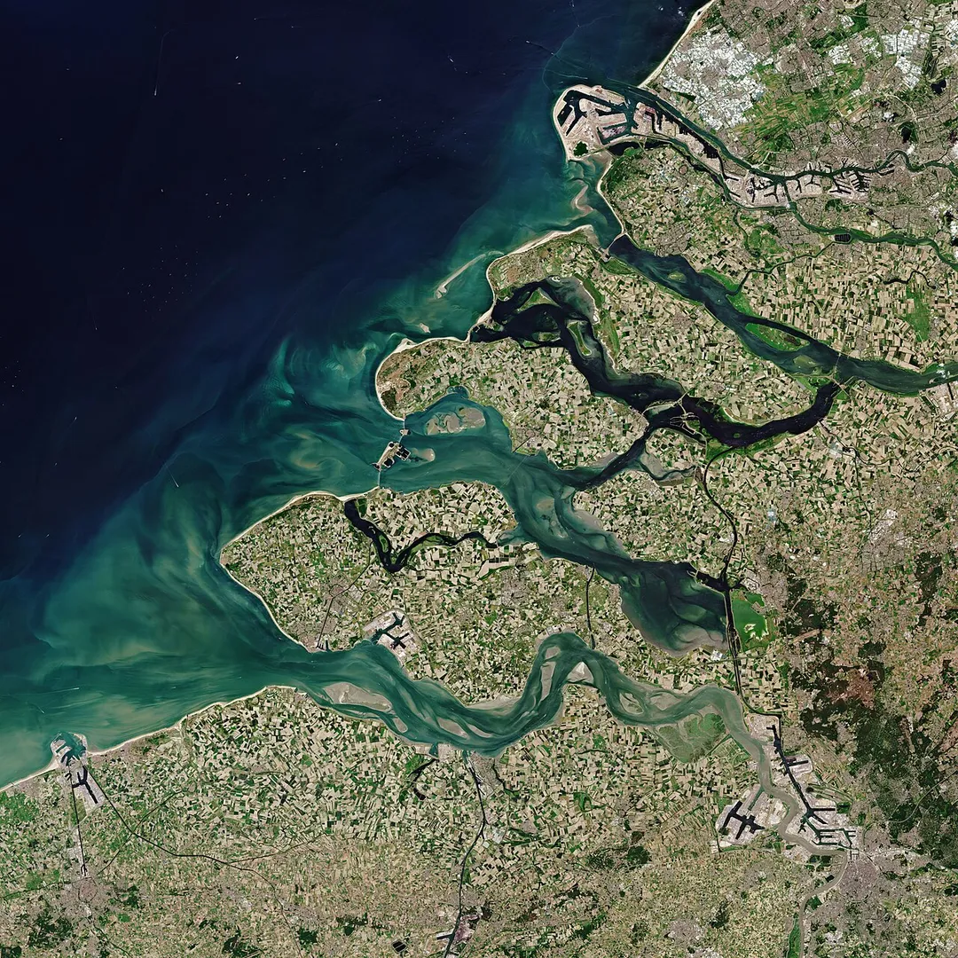
The Copernicus Sentinel-2 mission takes us over Zeeland – the westernmost province in the Netherlands.Zoom in to see this image at its full 10 m resolution.Located around 150 km from Amsterdam, Zeeland consists of a complex system of islands, peninsulas and waterways. It also comprises Zeeuwsch-Vlaanderen – a strip of the Flanders mainland between the Western Scheldt (Westerschelde) and Belgium.The province of Zeeland lies on the large river delta at the mouth of several rivers, like the Scheldt (Schelde) and Meuse (Maas) rivers. The lighter aqua colours in the image depict the shallow waters of the delta with riverbeds and several sandbanks visible. The brown coloured waters indicate a higher sediment content, which contrasts with the darker waters of the North Sea.The Port of Rotterdam, the largest seaport in Europe, is visible top-right in the image. Antwerp, in Belgium, is visible in the bottom-right and the quaint city of Bruges can be seen in the bottom-left of the image.Zeeland is one of the main agricultural provinces in the Netherlands with one of the largest areas of arable farmland. The patchwork of agricultural fields visible on the islands and mainland show the fields in the various stages of growth or harvest. The area supports cereals, potatoes, beets, cattle and horticulture.Large parts of Zeeland, which translates to ‘sea land,’ lie below sea level. The province was the site of a deadly flood in 1953 brought on by a combination of high spring tides and a strong windstorm that severely damaged the low-lying coastal region.As a result, the Dutch government began to implement the Delta Project – an elaborate system of dykes, canals, dams and bridges to hold back the North Sea. In this image, the 9km-long Eastern Scheldt Storm Surge Barrier (Oosterscheldekering) is visible between the islands of Schouwen-Duiveland and Noord-Beveland.Since sea-level rise is a key indicator of climate change, accurately monitoring the changing height of the sea surface over decades is essential for climate science, for policy-making and, ultimately, for protecting the lives of those in low-lying regions at risk.The Copernicus Sentinel-6 Michael Freilich satellite, set to launch in November, is the first of two identical satellites to be launched sequentially to provide accurate measurements of sea level change.Both satellites will reach 66°N and 66°S – a specific orbit occupied by the earlier missions that supplied the reference sea-surface height data over the last three decades. This orbit will allow for 95% of Earth’s ice-free ocean to be mapped every 10 days.This image, acquired on 30 May 2020, is also featured on the Earth from Space video programme.
Hoofdstraat 10 Noordwijk, gereformeerde kerk en pastorie, 1895, eerste serie prentbriefkaarten met rode letters, nr. 10 (1895).
Photo by No machine-readable author provided. Maschinenjunge assumed (based on copyright claims).
Destinations
Home›Destinations›Sluisoord
EuropeNetherlandsGelderland

Sluisoord

Gelderland, Netherlands · Europe

About Sluisoord

Sluisoord works well as a base: 20km from Hoge Veluwe National Park.

Sluisoord is in Gelderland, Netherlands, with about 4,200 people. You drive on the right here.

Where to Stay in Sluisoord

Compare prices across Booking.com, Airbnb, Expedia, and more. Select your dates to see availability.

Filter presets

Pick your must-haves once: provider links open pre-filtered. Each filter lists which sites it applies to.

Booking.comExpediaTripAdvisorHotels.comAgodaAirbnb

Compare before you book!

Prices can vary significantly between platforms. We recommend checking at least 2-3 sites to find the best deal for your stay in Sluisoord.

Explore the Area

Discover famous landmarks, scenic roads, and more near Sluisoord.

Loading map...
Open in Google Maps

Frequently Asked Questions

What is there to see near Sluisoord?

Within an hour or so of Sluisoord: Kröller-Müller Museum (18 km), Hoge Veluwe National Park (20 km), Posbank (22 km), Walibi Holland (28 km).

Are there any good drives near Sluisoord?

The nearest famous roads are Houtribdijk and Afsluitdijk.

Where is Sluisoord?

Sluisoord is in Gelderland, Netherlands.

Road trip

Drive to Sluisoord

Add it as a stop and the planner works out the driving, the nights and what's worth seeing on the way.

Start planning

What's nearby?

Swipe through places to go

Places within a drive of Sluisoord. Keep the ones you like and add them to your trip.

Explore now

Quick Information

Population
4,205
Continent
Europe
Country
Netherlands
Region
Gelderland
Timezone
Europe/Amsterdam
Coordinates
52.2229, 5.9814

Emergency & Services

Essential numbers in Netherlands

Police
112
Ambulance
112
Fire
112
Non-emergency police
0900-8844
Driving side
right

Watch for cyclists. They generally have priority.

Full driving guide for Netherlands

Tags

EuropeNetherlandsGelderlandTown

Worth the detour from Sluisoord

8 notable places within an hour's drive.

museum

Kröller-Müller Museum

Museum deep inside Hoge Veluwe National Park holding the world's second-largest Van Gogh collection plus a 25-hectare sculpture garden with Rodin, Moore and Dubuffet; free white bicycles carry you there through the park.

18 km · about 20 min drive

national park

Hoge Veluwe National Park

Cycle free white bikes across heath, dune and forest to the Kröller-Müller museum's Van Goghs in this vast wild park.

20 km · about 25 min drive

photogenic

Posbank

Rolling heathland hills of Veluwezoom National Park reached by a scenic drive up the Beekhuizenseweg, in late August the moors turn purple, and misty sunrises here are the most photographed in the Netherlands.

22 km · about 25 min drive

landmark

Walibi Holland

Dutch thrill park near Amsterdam known for intense roller coasters and a fun Halloween Fright Nights event.

28 km · about 35 min drive

restaurant

De Librije

The Netherlands' only three-Michelin-star restaurant, set in a former prison complex in Zwolle, where the late Jonnie Boer's team under chef Nelson Tanate has held the top rating since 2004.

33 km · about 40 min drive

landmark

Schokland

Former Zuiderzee island now stranded in the Noordoostpolder, the Netherlands' first UNESCO World Heritage Site.

48 km · about 55 min drive

landmark

Naarden-Vesting

The best-preserved star fortification town in Europe, a double-moated six-pointed star of 17th-century ramparts enclosing a grid of gabled streets, 25 minutes from Amsterdam yet ignored by most itineraries.

56 km · about 65 min drive

landmark

Giethoorn

Car-free village known as the 'Dutch Venice' where thatched-roof farmhouses are connected by canals and wooden bridges.

58 km · about 65 min drive

Driving roads near Sluisoord

2 named roads, passes and coastal drives within 150km.

  • 60 kmHoutribdijkA 26 km dike road (N302) running straight across the water between Enkhuizen and Lelystad, splitting the IJsselmeer from the Markermeer with sea views on both sides.
Driving in Netherlands

Drives on
the right
Petrol
~€2.04/litre
Motorway tolls
None

When to drive here

April to October

Nearby Destinations

Other places to explore near Sluisoord.

Anklaar

🇳🇱 Netherlands

1 km awayPop. 3,865

Kerschoten

🇳🇱 Netherlands

2 km awayPop. 3,540

Apeldoorn

🇳🇱 Netherlands

2 km awayPop. 136,670

Sprengenweg-Noord

🇳🇱 Netherlands

2 km awayPop. 1,120

Driehuizen

🇳🇱 Netherlands

3 km awayPop. 4,610

Orden

🇳🇱 Netherlands

4 km awayPop. 6,385

Vaassen

🇳🇱 Netherlands

7 km awayPop. 12,719

Beekbergen

🇳🇱 Netherlands

7 km awayPop. 2,545

Plan a trip around Sluisoord

Netherlands road trip planner

Your trip starts here

Plan a road trip from Sluisoord.

Pick the days, drop in the stops, and share it with whoever's coming.

Start planning
PYRT

The ultimate road trip planning platform. Discover 150,000+ destinations worldwide, plan scenic routes, and create unforgettable adventures.

Inspiration

  • Discover Trips
  • Travel Guides
  • Community

The Product

  • Calendar Planner
  • Integrations
  • How It Works
  • Collaboration Mode
  • Get the App
  • Merchandise: PYRT Supply Co.
  • Become a Creator
  • Trip Marketplace

Plan Your Trip

  • Road Trip Planner
  • Famous Routes
  • Drive Times & Distances
  • Planners by Country
  • Best Road Trip Planner App
  • Discover Road Trips
  • Events
  • Travel Guides
  • How It Works
  • My Trips
  • Community Groups

Company

  • Terms of Service
  • Privacy Policy
  • About PYRT
  • Support
  • Contact Us
  • Sign In
  • Create Account

© 2026 Plan Your Road Trips. All rights reserved.

•[email protected]
Data sources:GeoNames (CC BY 4.0)•Wikimedia Commons (CC BY-SA)•Mapbox•Photography: George Lawrence