PYRTPlan Your Road Trips
Create TripCommunityMerchandise
PYRTPlan Your Road Trips
Create TripCommunityMerchandise
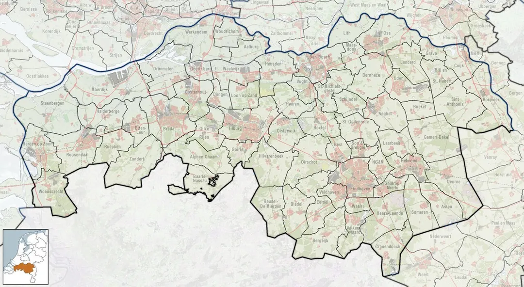
Referentiekaart van Provincie Noord-Brabant, met indeling van gemeenten (2010) en impressie van het landschap.
Door Jan-Willem van Aalst, samengesteld uit publiek beschikbare geo-data:

Referentie-ondergrond (kustlijn, steden, wegen) gerasterd uit de OpenStreet Map OSM. (http://www.openstreetmap.org/index.html) Inhoud is beschikbaar onder de Creative Commons Attribution-ShareAlike 3.0 license.
Referentie-ondergrond op water bewerkt vanuit http://satfoto.geoserve.nl/false-nl/index.html. Gebruik is vrij met bronvermelding NLR en ESA.
Vectorgrenzen van gemeenten en regio's vrij ter beschikking gesteld met dank aan cartografen van brandweerregio's Hollands-Midden en IJsselland; gerasterd in Photoshop.
Hoogte-aanduidingen (reliëf) gerasterd uit de AHN Viewer (http://www.ahn.nl/kaart/); gebruik is vrij met bronvermelding (c) AHN, www.ahn.nl;
Overige kenmerken op de kaart: eigen tekenwerk van Jan-Willem van Aalst, op basis van gerasterde gemeentegrenzen.
Zicht op een deel van de Sint-Willibrorduskerk in Sint Willebrord
This is an image of rijksmonumentcomplex number
Photo by Janwillemvanaalst
Destinations
Home›Destinations›Sint Willebrord
EuropeNetherlandsNorth Brabant

Sint Willebrord

North Brabant, Netherlands · Europe

About Sint Willebrord

Sint Willebrord is worth a stop: 5 minutes from Bosschenhoofd, 27km from Biesbosch National Park.

Sint Willebrord is in North Brabant, Netherlands, with about 8,700 people. You drive on the right here. The nearest town is Bosschenhoofd, about 4 km away.

Sint Willebrord is a town in the municipality of Rucphen in the Netherlands. It is also known by the name 't Heike which was the semi-official name up until 1950/1970 (mostly written as Theike, or less often Heike), which is the diminutive form of hei (heath) in local dialect. During Carnaval the town goes by the name

Read more of Heikneutersland, meaning ´Hillbillies´ land´ or ´Redneck's land´.

Read more on Wikipedia

Where to Stay in Sint Willebrord

Compare prices across Booking.com, Airbnb, Expedia, and more. Select your dates to see availability.

Filter presets

Pick your must-haves once: provider links open pre-filtered. Each filter lists which sites it applies to.

Booking.comExpediaTripAdvisorHotels.comAgodaAirbnb

Compare before you book!

Prices can vary significantly between platforms. We recommend checking at least 2-3 sites to find the best deal for your stay in Sint Willebrord.

Explore the Area

Discover famous landmarks, scenic roads, and more near Sint Willebrord.

Loading map...
Open in Google Maps

Frequently Asked Questions

What is there to see near Sint Willebrord?

Within an hour or so of Sint Willebrord: Biesbosch National Park (27 km), Efteling (34 km), Kinderdijk Windmills (38 km), Cathedral of Our Lady, Antwerp (39 km).

Are there any good drives near Sint Willebrord?

The nearest famous roads are Brouwersdam, Koninklijke Baan Coast Road and Houtribdijk.

Where is Sint Willebrord?

Sint Willebrord is in North Brabant, Netherlands, about 4 km from Bosschenhoofd.

Road trip

Drive to Sint Willebrord

Add it as a stop and the planner works out the driving, the nights and what's worth seeing on the way.

Start planning

What's nearby?

Swipe through places to go

Places within a drive of Sint Willebrord. Keep the ones you like and add them to your trip.

Explore now

Quick Information

Population
8,655
Continent
Europe
Country
Netherlands
Region
North Brabant
Timezone
Europe/Amsterdam
Coordinates
51.5483, 4.5889

Emergency & Services

Essential numbers in Netherlands

Police
112
Ambulance
112
Fire
112
Non-emergency police
0900-8844
Driving side
right

Watch for cyclists. They generally have priority.

Full driving guide for Netherlands

Tags

EuropeNetherlandsNorth BrabantTown

Worth the detour from Sint Willebrord

8 notable places within an hour's drive.

national park

Biesbosch National Park

Freshwater tidal wetland of creeks and willow forest between Dordrecht and Werkendam, with visitor centres and car parks.

27 km · about 30 min drive

landmark

Efteling

Enchanting Dutch fairy-tale theme park with immersive storytelling, dark rides, and world-class roller coasters.

34 km · about 40 min drive

landmark

Kinderdijk Windmills

UNESCO World Heritage site featuring 19 iconic 18th-century windmills in a quintessential Dutch polder landscape.

38 km · about 45 min drive

cathedral

Cathedral of Our Lady, Antwerp

Belgium's tallest Gothic building housing masterpieces by Rubens, with a UNESCO-listed 123-metre tower visible across Flanders.

39 km · about 45 min drive

landmark

Antwerp Zoo

Historic Belgian zoo next to the central train station, one of the oldest in the world, founded in 1843.

39 km · about 45 min drive

landmark

Antwerpen-Centraal

A cathedral-like railway station of marble, gilt and glass, repeatedly voted one of the most beautiful in the world.

39 km · about 45 min drive

museum

Plantin-Moretus Museum

The world's oldest surviving printing house, run by the Plantin family in Antwerp from 1576 to 1867 and the only museum on the UNESCO World Heritage list: complete with the two oldest printing presses in existence and a Gutenberg Bible.

39 km · about 45 min drive

bridge

Erasmusbrug

Rotterdam's swan-necked cable-stayed bridge soars over the Maas, a striking modern icon glowing over the river at night.

41 km · about 45 min drive

Driving roads near Sint Willebrord

  • 41 kmErasmusbrugRotterdam's swan-necked cable-stayed bridge soars over the Maas, a striking modern icon glowing over the river at night.
  • 49 kmZeeland BridgeElegant 5 km bridge over the Oosterschelde estuary, the longest in the Netherlands when opened in 1965. Its endless procession of arches makes one of the country's most photogenic drives.
  • 56 kmBrouwersdamDelta Works dam carrying the N57 between two Zeeland islands, with the North Sea on one side, the Grevelingen lagoon on the other, and kitesurfers filling the sky.
  • 58 kmWestern Scheldt TunnelAt 6.6 km the longest road tunnel in the Netherlands, diving under the busy Western Scheldt shipping lane to link Zeeland with Zeelandic Flanders since 2003.
  • 58 kmWesterscheldetunnelTolled 6.6-kilometre road tunnel under the Western Scheldt linking Zeelandic Flanders to Zuid-Beveland, replacing two ferries.
  • 63 kmOosterscheldekeringThe colossal storm-surge barrier crossing the Oosterschelde, the showpiece of Holland's Delta Works flood defences.

Driving in Netherlands

Drives on
the right
Petrol
~€2.04/litre
Motorway tolls
None

When to drive here

April to October

Nearby Destinations

Other places to explore near Sint Willebrord.

Oudenbosch

🇳🇱 Netherlands

6 km awayPop. 13,380

Kalsdonk

🇳🇱 Netherlands

8 km awayPop. 4,250

Roosendaal

🇳🇱 Netherlands

9 km awayPop. 77,725

Oud Gastel

🇳🇱 Netherlands

10 km awayPop. 5,305

Prinsenbeek

🇳🇱 Netherlands

10 km awayPop. 10,720

Princenhage

🇳🇱 Netherlands

11 km awayPop. 8,535

Nispen

🇳🇱 Netherlands

11 km awayPop. 1,245

Essen

🇧🇪 Belgium

12 km awayPop. 10,000

Plan a trip around Sint Willebrord

Netherlands road trip planner

Your trip starts here

Plan a road trip from Sint Willebrord.

Pick the days, drop in the stops, and share it with whoever's coming.

Start planning
PYRT

The ultimate road trip planning platform. Discover 150,000+ destinations worldwide, plan scenic routes, and create unforgettable adventures.

Inspiration

  • Discover Trips
  • Travel Guides
  • Community

The Product

  • Calendar Planner
  • Integrations
  • How It Works
  • Collaboration Mode
  • Get the App
  • Merchandise: PYRT Supply Co.
  • Become a Creator
  • Trip Marketplace

Plan Your Trip

  • Road Trip Planner
  • Famous Routes
  • Drive Times & Distances
  • Planners by Country
  • Best Road Trip Planner App
  • Discover Road Trips
  • Events
  • Travel Guides
  • How It Works
  • My Trips
  • Community Groups

Company

  • Terms of Service
  • Privacy Policy
  • About PYRT
  • Support
  • Contact Us
  • Sign In
  • Create Account

© 2026 Plan Your Road Trips. All rights reserved.

•[email protected]
Data sources:GeoNames (CC BY 4.0)•Wikimedia Commons (CC BY-SA)•Mapbox•Photography: George Lawrence