PYRTPlan Your Road Trips
Create TripCommunityMerchandise
PYRTPlan Your Road Trips
Create TripCommunityMerchandise
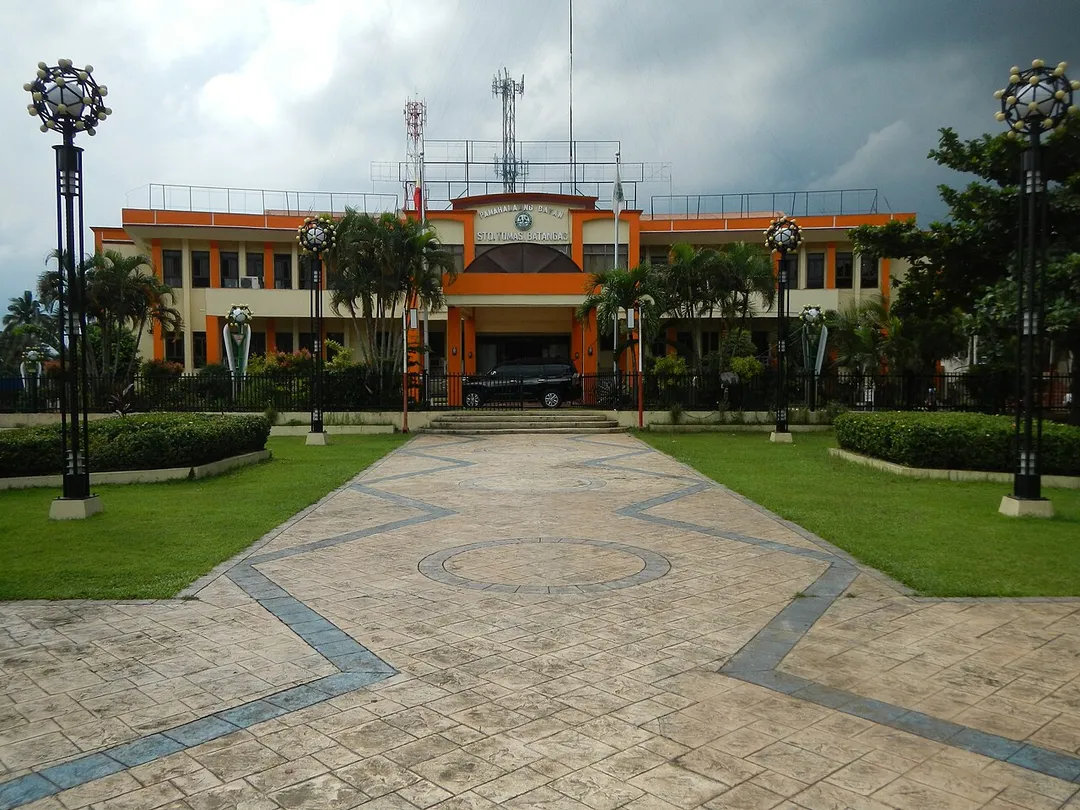
Sto.Tomas Municipal[1] Coordinates:   14°6'38"N   121°8'32"E & Miguel Malvar[2] beside and in front of the Shrine in the Town Hall of Santo Tomas[3] Miguel Malvar Museum and Library: Of Battles and Surrender – Sto. Tomas, Batangas, Philippines [4] Miguel Malvar: The Story of the Great Batangueño General -- Located in the compound of the Sto. Tomas municipal hall is the Miguel Malvar Historical Landmark (MHL). The shrine (and public library) is under the National Historical Commission of the Philippines.[5] [6] Gen. Miguel Malvar Park Coordinates:   14°6'37"N   121°8'33"E - List of Cultural Properties of the Philippines in CALABARZON [7] PH-40-0004 Miguel Malvar Monument 14°06′37″N 121°08′34″E
Cultural [8] [9]  Santo Tomas, Batangas[10] Website

Santo Tomas (also spelled as Sto. Tomas) is a first class municipality in the province of Batangas,[11] Philippines. According to the 2010 census, it has a population of 123,668 people. The town is a gateway to the province from Laguna hometown of Philippine Revolution and Philippine-American War hero Miguel Malvar.[12] The patron of Santo Tomas is Saint Thomas Aquinas,[13] patron of Catholic schools celebrates his feast day every 7 March.Election Results 2013 Santo Tomas mayoral bet  Edna Sanchez  accused of vote-buying [14] Coordinates:   14°3'44"N   121°10'24"E Geographical location: Batangas, Region 4, Philippines, Asia Geographical coordinates: 14° 6' 33" North, 121° 8' 31" East This place is situated in Batangas, Region 4, Philippines, its geographical coordinates are 14° 6' 33" North, 121° 8' 31" East and its original name (with diacritics) is Santo Tomas. [15]
Santa Anastacia, Santo Tomas, Batangas Barangays San Rafael 14°7'42"N   121°9'6"E Santa Anastacia  14°8'6"N   121°8'6"E Santo Tomas, Batangas Light Industry and Science Park  14°8'6"N   121°8'51"E along Maharlika Highway (Santo Tomas, Batangas section) Pan-Philippine Highway; First Philippine Industrial Park I (Santa Anastacia, Santo Tomas, Batangas); registered with the Philippine Economic Zone Authority Philippine Economic Zone Authority bounded by the Welcome arch-signs of Batangas Province - Viga Bridge I (Maharlika Highway, Santa Anastacia, Santo Tomas, Batangas & Makiling, Calamba) in BarangaysMakiling, Calamba Milagrosa Turbina,_Calamba Poblacion I, Calamba Poblacion II, III, IV, VI and VII, Calamba and Poblacion V, Calamba Calamba, Laguna Poblacion 14°12'32"N  121°9'46"E Calamba Poblacion (Note: Judge Florentino Floro, the owner, to repeat, Donor Florentino Floro of all these photos hereby donate gratuitously, freely and unconditionally Judge Floro all these photos to and for Wikimedia Commons, exclusively, for public use of the public domain, and again without any condition whatsoever).
Maharlika Highway, Sto. Tomas, Batangas, Apr 2024
Photo by Ramon FVelasquez
Destinations
Home›Destinations›Santo Tomas
AsiaPhilippinesCalabarzon

Santo Tomas

Calabarzon, Philippines · Asia

About Santo Tomas

Santo Tomas is worth a stop: 5 minutes from Santor, 58km from Masungi Georeserve.

Santo Tomas is in Calabarzon, Philippines, with about 57,000 people. You drive on the right here. The nearest town is Santor, about 4 km away.

Where to Stay in Santo Tomas

Compare prices across Booking.com, Airbnb, Expedia, and more. Select your dates to see availability.

Filter presets

Pick your must-haves once: provider links open pre-filtered. Each filter lists which sites it applies to.

Booking.comExpediaTripAdvisorHotels.comAgodaAirbnb

Compare before you book!

Prices can vary significantly between platforms. We recommend checking at least 2-3 sites to find the best deal for your stay in Santo Tomas.

Explore the Area

Discover famous landmarks, scenic roads, and more near Santo Tomas.

Loading map...
Open in Google Maps

Frequently Asked Questions

What is there to see near Santo Tomas?

Within an hour or so of Santo Tomas: Enchanted Kingdom (20 km), National Museum of the Philippines (56 km), Intramuros (Manila) (56 km), Masungi Georeserve (58 km).

Where is Santo Tomas?

Santo Tomas is in Calabarzon, Philippines, about 4 km from Santor.

Road trip

Drive to Santo Tomas

Add it as a stop and the planner works out the driving, the nights and what's worth seeing on the way.

Start planning

What's nearby?

Swipe through places to go

Places within a drive of Santo Tomas. Keep the ones you like and add them to your trip.

Explore now

Quick Information

Population
57,438
Continent
Asia
Country
Philippines
Region
Calabarzon
Timezone
Asia/Manila
Coordinates
14.1079, 121.1414

Emergency & Services

Essential numbers in Philippines

Police
911
Ambulance
911
Fire
911
Driving side
right
Full driving guide for Philippines

Tags

AsiaPhilippinesCalabarzonTown

Worth the detour from Santo Tomas

4 notable places within an hour's drive.

landmark

Enchanted Kingdom

The Philippines' first and only world-class theme park in Santa Rosa, Laguna with seven themed zones.

20 km · about 25 min drive

museum

National Museum of the Philippines

Houses the Philippines' most important cultural treasures including the Spoliarium and pre-colonial gold artifacts.

56 km · about 65 min drive

landmark

Intramuros (Manila)

The historic walled city of Manila built during the Spanish colonial period, containing Fort Santiago and San Agustin Church.

56 km · about 65 min drive

natural wonder

Masungi Georeserve

A conservation area in the Rizal karst where rope courses, hanging bridges and a steel spiderweb platform thread between 60-million-year-old limestone spires. Entry is by booked guided trail only.

58 km · about 65 min drive

When to drive here

Year-round

Tropical latitude: plan around the wet season rather than temperature.

Nearby Destinations

Other places to explore near Santo Tomas.

Tanauan

🇵🇭 Philippines

3 km awayPop. 68,456

Bitin

🇵🇭 Philippines

9 km awayPop. 5,758

San Andres

🇵🇭 Philippines

10 km awayPop. 5,527

Calamba

🇵🇭 Philippines

12 km awayPop. 575,046

Los Baños

🇵🇭 Philippines

13 km awayPop. 117,030

Bay

🇵🇭 Philippines

18 km awayPop. 33,547

Cabuyao

🇵🇭 Philippines

18 km awayPop. 308,745

Plan a trip around Santo Tomas

Asia road trip planner

Your trip starts here

Plan a road trip from Santo Tomas.

Pick the days, drop in the stops, and share it with whoever's coming.

Start planning
PYRT

The ultimate road trip planning platform. Discover 150,000+ destinations worldwide, plan scenic routes, and create unforgettable adventures.

Inspiration

  • Discover Trips
  • Travel Guides
  • Community

The Product

  • Calendar Planner
  • Integrations
  • How It Works
  • Collaboration Mode
  • Get the App
  • Merchandise: PYRT Supply Co.
  • Become a Creator
  • Trip Marketplace

Plan Your Trip

  • Road Trip Planner
  • Famous Routes
  • Drive Times & Distances
  • Planners by Country
  • Best Road Trip Planner App
  • Discover Road Trips
  • Events
  • Travel Guides
  • How It Works
  • My Trips
  • Community Groups

Company

  • Terms of Service
  • Privacy Policy
  • About PYRT
  • Support
  • Contact Us
  • Sign In
  • Create Account

© 2026 Plan Your Road Trips. All rights reserved.

•[email protected]
Data sources:GeoNames (CC BY 4.0)•Wikimedia Commons (CC BY-SA)•Mapbox•Photography: George Lawrence