PYRTPlan Your Road Trips
Create TripCommunityMerchandise
PYRTPlan Your Road Trips
Create TripCommunityMerchandise
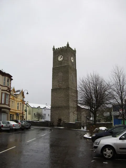
Raphoe, County Donegal.
Prior School, Raphoe To celebrate their foundation of the 400th Anniversary of the five Royal Schools of Ulster the five schools, The Royal School Armagh, Portora Royal School, Enniskillen, The Royal School Dungannon, Cavan Royal School, and The Royal and Prior School Raphoe joined together in a unique cross-border initiative and formed a separate company known as “The 1608 Royal Schools” to focus on their histories. In March, 2008, HRH The Queen, accompanied by His Royal Highness The Duke of Edinburgh, was guest of honour at a reception in The Royal School Armagh
Cropped version of Image:Raphoe Town - geograph.org.uk - 998448.jpg
Photo by james denham
Destinations
Home›Destinations›Raphoe
EuropeIrelandUlster

Raphoe

Ulster, Ireland · Europe

About Raphoe

Raphoe is worth a stop: 10 minutes from Convoy, 31km from Glenveagh National Park.

Raphoe is in Ulster, Ireland, with about 1,200 people. You drive on the left here. The nearest town is Convoy, about 5 km away.

Raphoe ( rə-FOH; Irish: Ráth Bhoth) is a small town in County Donegal in the north-west of Ulster, the northern province in Ireland. It is the main town in the fertile district of East Donegal known as the Laggan. It gave its name to the Barony of Raphoe, which was later divided into the baronies of Raphoe North and

Read more Raphoe South, as well as to the Roman Catholic Diocese of Raphoe and the Church of Ireland (Anglican) Diocese of Derry and Raphoe. There is also a civil parish of Raphoe. The town is 12 km south-east of Letterkenny, and 23 km south-west of Derry. The Burn Dale (also known in English as the Burn Deele) is a burn (a small river) that flows a short distance to the south of Raphoe. The Burn Dale eventually flows, via the village of Ballindrait, into the River Foyle just north of Lifford.

Read more on Wikipedia

Where to Stay in Raphoe

Compare prices across Booking.com, Airbnb, Expedia, and more. Select your dates to see availability.

Filter presets

Pick your must-haves once: provider links open pre-filtered. Each filter lists which sites it applies to.

Booking.comExpediaTripAdvisorHotels.comAgodaAirbnb

Compare before you book!

Prices can vary significantly between platforms. We recommend checking at least 2-3 sites to find the best deal for your stay in Raphoe.

Explore the Area

Discover famous landmarks, scenic roads, and more near Raphoe.

Loading map...
Open in Google Maps

Frequently Asked Questions

What is there to see near Raphoe?

Within an hour or so of Raphoe: Derry City Walls (22 km), Glenveagh National Park (31 km), Poisoned Glen (36 km), Mount Errigal (37 km).

Are there any good drives near Raphoe?

The nearest famous roads are Mamore Gap, Glengesh Pass and Gleniff Horseshoe.

Where is Raphoe?

Raphoe is in Ulster, Ireland, about 5 km from Convoy.

Road trip

Drive to Raphoe

Add it as a stop and the planner works out the driving, the nights and what's worth seeing on the way.

Start planning

What's nearby?

Swipe through places to go

Places within a drive of Raphoe. Keep the ones you like and add them to your trip.

Explore now

Quick Information

Population
1,157
Continent
Europe
Country
Ireland
Region
Ulster
Timezone
Europe/Dublin
Coordinates
54.8747, -7.5983

Emergency & Services

Essential numbers in Ireland

Police
999
Ambulance
999
Fire
999
All emergencies
112
Driving side
left
Full driving guide for Ireland

Tags

EuropeIrelandUlsterTown

Worth the detour from Raphoe

8 notable places within an hour's drive.

landmark

Derry City Walls

The only completely intact walled city in Ireland, a 1.5km 17th-century rampart circling historic Derry.

22 km · about 25 min drive

national park

Glenveagh National Park

A remote wilderness of mountains, lakes and a fairytale castle in the heart of the Donegal highlands.

31 km · about 35 min drive

scenic viewpoint

Poisoned Glen

A steep-sided glen below Errigal at Dunlewey, entered past a roofless Victorian church.

36 km · about 40 min drive

scenic viewpoint

Mount Errigal

Donegal's highest peak, a pale quartzite cone above the R251 in the Derryveagh Mountains, climbed in about three hours return.

37 km · about 45 min drive

mountain pass

Mamore Gap

Steep, narrow pass climbing to 260m through the Urris Hills of Inishowen, with a holy well and grotto at the summit and a plunging descent to the Atlantic at Urris. Part of the Inishowen 100 drive; low gears essential.

41 km · about 45 min drive

landmark

Fanad Head Lighthouse

One of the world's most photographed lighthouses, perched on a rugged Donegal headland between Atlantic and lough.

45 km · about 50 min drive

scenic viewpoint

Horn Head

A quartzite headland north of Dunfanaghy circled by a narrow loop road, with 180m sea cliffs and nesting seabirds.

47 km · about 55 min drive

scenic viewpoint

Binevenagh

A basalt escarpment above Limavady with a small lake on top, used as the Dothraki grasslands in Game of Thrones.

51 km · about 60 min drive

Driving roads near Raphoe

  • 36 kmPoisoned GlenA steep-sided glen below Errigal at Dunlewey, entered past a roofless Victorian church.
  • 37 kmMount ErrigalDonegal's highest peak, a pale quartzite cone above the R251 in the Derryveagh Mountains, climbed in about three hours return.
  • 41 kmMamore GapSteep, narrow pass climbing to 260m through the Urris Hills of Inishowen, with a holy well and grotto at the summit and a plunging descent to the Atlantic at Urris. Part of the Inishowen 100 drive; low gears essential.
  • 47 kmHorn HeadA quartzite headland north of Dunfanaghy circled by a narrow loop road, with 180m sea cliffs and nesting seabirds.
  • 51 kmBinevenaghA basalt escarpment above Limavady with a small lake on top, used as the Dothraki grasslands in Game of Thrones.
  • 55 kmGortmore Viewpoint (Manannán Mac Lir)A viewpoint on Binevenagh above the Bishop's Road with a sculpture of the sea god Manannán Mac Lir looking out to Donegal.

Driving in Ireland

Drives on
the left
Petrol
~€1.78/litre
Motorway tolls
~€2.10/100km

When to drive here

April to October

Nearby Destinations

Other places to explore near Raphoe.

Convoy

🇮🇪 Ireland

5 km awayPop. 1,526

Strabane

🇬🇧 United Kingdom

10 km awayPop. 14,198

Letterkenny

🇮🇪 Ireland

12 km awayPop. 19,274

Castlederg

🇬🇧 United Kingdom

19 km awayPop. 2,822

Londonderry County Borough

🇬🇧 United Kingdom

23 km awayPop. 87,153

Derry

🇬🇧 United Kingdom

23 km awayPop. 83,652

Buncrana

🇮🇪 Ireland

30 km awayPop. 6,785

Eglinton

🇬🇧 United Kingdom

31 km awayPop. 3,818

Plan a trip around Raphoe

Ireland road trip planner

Your trip starts here

Plan a road trip from Raphoe.

Pick the days, drop in the stops, and share it with whoever's coming.

Start planning
PYRT

The ultimate road trip planning platform. Discover 150,000+ destinations worldwide, plan scenic routes, and create unforgettable adventures.

Inspiration

  • Discover Trips
  • Travel Guides
  • Community

The Product

  • Calendar Planner
  • Integrations
  • How It Works
  • Collaboration Mode
  • Get the App
  • Merchandise: PYRT Supply Co.
  • Become a Creator
  • Trip Marketplace

Plan Your Trip

  • Road Trip Planner
  • Famous Routes
  • Drive Times & Distances
  • Planners by Country
  • Best Road Trip Planner App
  • Discover Road Trips
  • Events
  • Travel Guides
  • How It Works
  • My Trips
  • Community Groups

Company

  • Terms of Service
  • Privacy Policy
  • About PYRT
  • Support
  • Contact Us
  • Sign In
  • Create Account

© 2026 Plan Your Road Trips. All rights reserved.

•[email protected]
Data sources:GeoNames (CC BY 4.0)•Wikimedia Commons (CC BY-SA)•Mapbox•Photography: George Lawrence