PYRTPlan Your Road Trips
Create TripCommunityMerchandise
PYRTPlan Your Road Trips
Create TripCommunityMerchandise
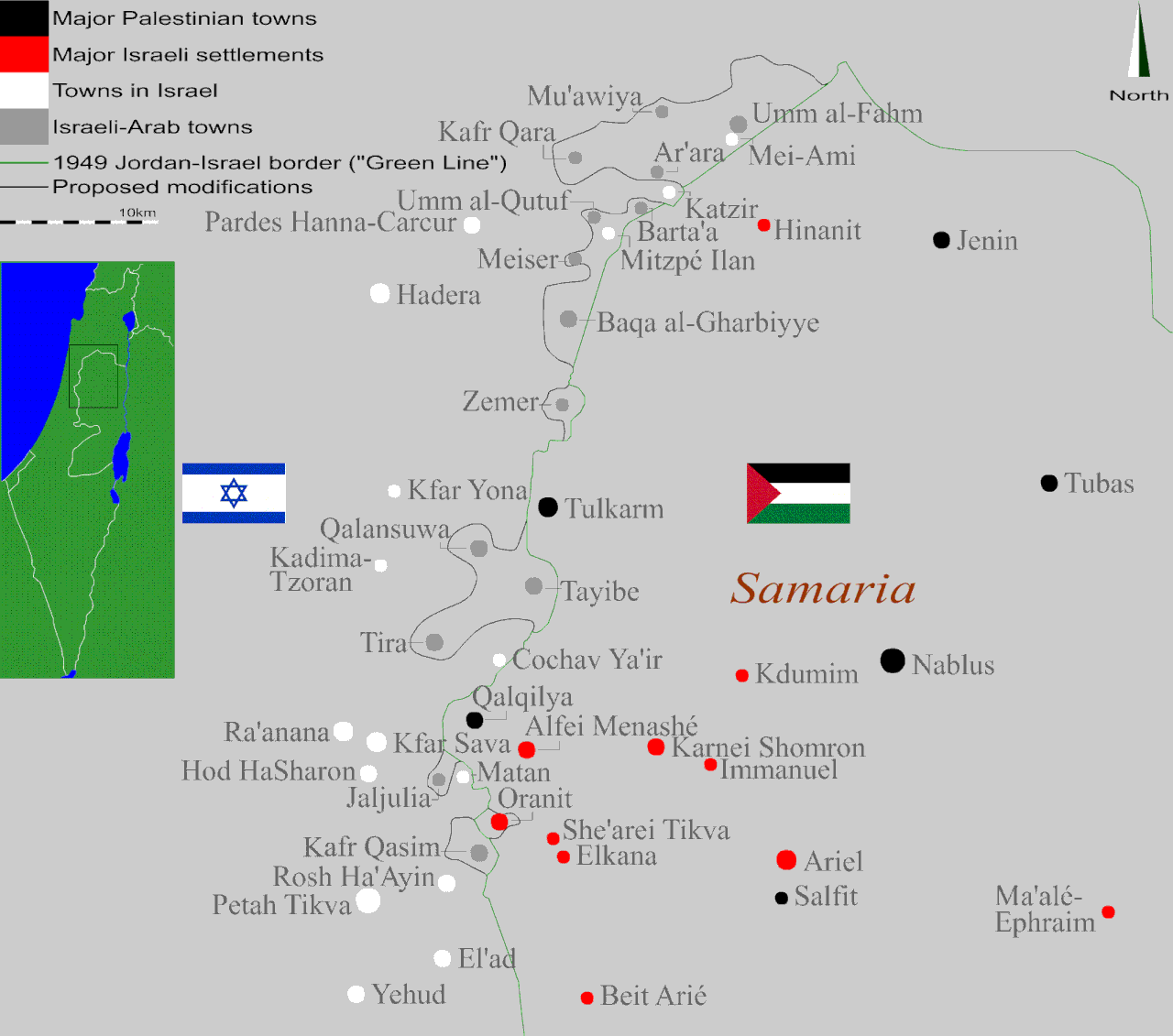
To-the-topic examination of the experimental proposals and ideas all relating to the design of the Israel-Palestine border in the constellation of a two-state solution while one suggests that the Rhodes cease-fire line of 1949 separating Israel and the Palestinians be adapted with the objective to reflect a modern pragmatic political thinking that pursues an international division after an extended ethnic key; - in that respect all Israeli anyway-illegal settlements east of that existing line will be either dismantled or accept Palestinian rule in the future Palestinian State and the Arab villages and towns that fell within the Israeli side and are located directly adjacent to the border will, in turn, be included in the Palestinian entity and thus severed from the majorly-Jewish Israel.
This vision has met strong oppositin amidst both the Israeli Arabs themselves and large groups of Israeli right-wing supporters since first discussed, as well as deep latent objection among those in Palestine who reject, as ever since the dawn of the Mideast Conflict and as their fundamentalistic Jewish counterparts, the concept of a territorial partition whatsoever while favoring to maintain the fizz and the reciprocal attrition until gaining the entire historic land, by demography or arm equally. On the contrary, this outlook is advocated, although not widely, by pragmatic zionists who rebuff the bigotic martyrism of both sides and consider a two nation-state resolution as the only one sustainable way to ensure a peaceful future. Alongside, it is adopted by Israelis who openly assume the prospect of the gradual erosion of the Israeli sovereign hegemony as a Western democracy by natural growth of the Arab population and there sometimes observe the Arab citizens as a threat from within and are willing to reduce Israel's already-small area in favor of securing the Hebrew character of the country, which attracts accusations of racial exclusionism from both Jews and Arabs.
This sketch then reviews the practical aspect of a possible annexation of areas in Israel to the Palestinian state to allow an ethnic consecutiveness, as a two-dimensional mapping study that flattens, truly, a few variables yet enables to get some visual grip of how our shared border may look – focusing on the northern West Bank frontier's villages and towns, being the densest of regions with Muslim Arab inhabitants interspersed through Israeli localities on both sides of the original cease-fire line. According to this plan all Israeli settlements built following the 1967 War on the occupied ground are to be evacuated and their dwellers settled back in Israel-proper, except Oranit which is included within Israel's boundaries despite its beyond-Green-Line position. Across that line, the Israeli-Arabs are re-bestowed of Palestinian citizenship - and their towns separated from the Israeli civil, national and political infrastructures by a new national border. They therefore become re-connected with their people in the Palestinian back-country who, in turn, gain a larger area to practice their national existance, with no single Arab person needing to displace. This border strives to indeed get as many Arab communities included in the Arab state through land contiguity while of course keeping the Israeli non-Arab villages with unchanged status, but two small Jewish communities of Israel-proper need to relocate due to their being almost enclaved by Arab population which neutralizes the practicability of trying to get the border to encircle them. These two villages, that join the 300,000 habitants of the Israeli settlements in the Palestinian territories having to migrate westwards, are Mitzpe Ilan and Mei Ami.
The map is thus an honest attempt to draw a border for Israel that is as reasonable and feasible as possible & derives from a spatial approach that aims to permit a maximal intuitive attitude from people living on both sides of the border.

A list of the Israeli settlements is available here
For a list of Arab settlements in Israel go here.
Photo by Orrling
Destinations
Home›Destinations›Oranit
AsiaPalestineWest Bank

Oranit

West Bank, Palestine · Asia

About Oranit

Oranit is worth a stop: 5 minutes from Ḩablah, 42km from Caesarea Maritima.

Oranit is in West Bank, Palestine, with about 9,000 people. The nearest town is Ḩablah, about 4 km away.

Oranit (Hebrew: אֳרָנִית) is an Israeli settlement and local council located in the Seam Zone of the West Bank, abutting and crossing the Green Line. It is surrounded by Horshim forest to the west, Rosh HaAyin and Kfar Qasim to the southwest, Sha'arei Tikva to the east, and Khirbet Abu Salman to the northeast. In 2024

Read more it had a population of 10,089. The international community considers Israeli settlements illegal under international law, though Israel disputes this.

Read more on Wikipedia

Where to Stay in Oranit

Compare prices across Booking.com, Airbnb, Expedia, and more. Select your dates to see availability.

Filter presets

Pick your must-haves once: provider links open pre-filtered. Each filter lists which sites it applies to.

Booking.comExpediaTripAdvisorHotels.comAgodaAirbnb

Compare before you book!

Prices can vary significantly between platforms. We recommend checking at least 2-3 sites to find the best deal for your stay in Oranit.

Explore the Area

Discover famous landmarks, scenic roads, and more near Oranit.

Loading map...
Open in Google Maps

Frequently Asked Questions

What is there to see near Oranit?

Within an hour or so of Oranit: Old Jaffa (24 km), Abu Hassan (Ali Karavan) (24 km), Caesarea Maritima (42 km), Yad Vashem (43 km).

Are there any good drives near Oranit?

The nearest famous roads are King's Highway and Scorpions Ascent (Ma'ale Akrabim).

Where is Oranit?

Oranit is in West Bank, Palestine, about 4 km from Ḩablah.

Road trip

Drive to Oranit

Add it as a stop and the planner works out the driving, the nights and what's worth seeing on the way.

Start planning

What's nearby?

Swipe through places to go

Places within a drive of Oranit. Keep the ones you like and add them to your trip.

Explore now

Quick Information

Population
8,955
Continent
Asia
Country
Palestine
Region
West Bank
Timezone
Asia/Hebron
Coordinates
32.1317, 34.9909

Tags

AsiaPalestineWest BankTown

Worth the detour from Oranit

8 notable places within an hour's drive.

landmark

Old Jaffa

One of the oldest port cities in the world with 4,000 years of history, now an artists' quarter with galleries, restaurants, and views of Tel Aviv's skyline.

24 km · about 30 min drive
restaurant

Abu Hassan (Ali Karavan)

A Jaffa hummus counter running since 1971, famous for masabacha made with whole chickpeas and extra tahini. It sells out and closes by mid-afternoon, and the queue starts well before that.

24 km · about 30 min drive

ancient ruins

Caesarea Maritima

A spectacular Roman-era port city with a grand amphitheater, aqueducts, and crusader fortifications on the Mediterranean coast.

42 km · about 50 min drive

museum

Yad Vashem

Israel's official memorial to the Holocaust, with deeply moving exhibits and a striking modernist museum built into a mountainside.

43 km · about 50 min drive

cathedral

Church of the Holy Sepulchre

Christianity's holiest site, built on the traditional locations of Jesus's crucifixion and burial.

45 km · about 50 min drive

landmark

Jerusalem Old City

A walled sacred city of one square kilometer containing holy sites for Judaism, Christianity, and Islam within four historic quarters.

46 km · about 55 min drive

landmark

Western Wall (Wailing Wall)

The holiest site where Jews can pray, a 2,000-year-old limestone remnant of the Second Temple retaining wall in the Old City of Jerusalem.

46 km · about 55 min drive

landmark

Dome of the Rock

The iconic gold-domed Islamic shrine on the Temple Mount/Haram al-Sharif, built in 691 CE over the sacred Foundation Stone.

46 km · about 55 min drive

Nearby Destinations

Other places to explore near Oranit.

Kafr Qāsim

🇮🇱 Israel

2 km awayPop. 23,823

Ḩablah

🇵🇸 Palestine

4 km awayPop. 5,945

Rosh Ha‘Ayin

🇮🇱 Israel

5 km awayPop. 72,881

Qalqīlyah

🇵🇸 Palestine

7 km awayPop. 43,212

‘Azzūn

🇵🇸 Palestine

8 km awayPop. 7,727

Bidyā

🇵🇸 Palestine

9 km awayPop. 8,065

Kfar Saba

🇮🇱 Israel

9 km awayPop. 110,456

Qarne Shomeron

🇵🇸 Palestine

10 km awayPop. 7,713

Plan a trip around Oranit

Asia road trip planner

Your trip starts here

Plan a road trip from Oranit.

Pick the days, drop in the stops, and share it with whoever's coming.

Start planning
PYRT

The ultimate road trip planning platform. Discover 150,000+ destinations worldwide, plan scenic routes, and create unforgettable adventures.

Inspiration

  • Discover Trips
  • Travel Guides
  • Community

The Product

  • Calendar Planner
  • Integrations
  • How It Works
  • Collaboration Mode
  • Get the App
  • Merchandise: PYRT Supply Co.
  • Become a Creator
  • Trip Marketplace

Plan Your Trip

  • Road Trip Planner
  • Famous Routes
  • Drive Times & Distances
  • Planners by Country
  • Best Road Trip Planner App
  • Discover Road Trips
  • Events
  • Travel Guides
  • How It Works
  • My Trips
  • Community Groups

Company

  • Terms of Service
  • Privacy Policy
  • About PYRT
  • Support
  • Contact Us
  • Sign In
  • Create Account

© 2026 Plan Your Road Trips. All rights reserved.

•[email protected]
Data sources:GeoNames (CC BY 4.0)•Wikimedia Commons (CC BY-SA)•Mapbox•Photography: George Lawrence