
film location
Weta Workshop, Miramar, Wellington
The effects house behind Middle-earth; its Wellington workshop tour displays original props, weapons and creature designs.
3 km · about 5 min drive
Wellington Region, New Zealand · Oceania
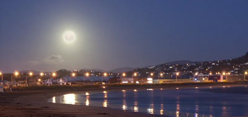
Lyall Bay is worth a stop: 4km from Mount Victoria Lookout, Wellington.
Lyall Bay is in Wellington Region, New Zealand, with about 2,700 people. You drive on the left here.
Lyall Bay is a bay and suburb on the south side of the Rongotai isthmus in Wellington, New Zealand.
The bay is a popular surf beach, featuring a breakwater at the eastern end. It is home to two surf lifesaving clubs and has also been the site of surf lifesaving championships. Lyall Bay is a very popular and safeRead more
swimming beach. The beach is only two thirds of its original size: the construction of Wellington International Airport took away the eastern third of the beach.
The suburb consists of most of the southern half of the Rongotai isthmus, although Wellington International Airport and a small industrial area next to it are often considered to be part of Rongotai. Lyall Bay is predominantly a residential area, but also contains a part of Wellington's Southern Walkway and the Southern Headlands Reserve. The suburb has a bus service and is near to the Kilbirnie shopping centre and the Tirangi Road Airport Retail Park. There is a primary school (Lyall Bay School), a Playcentre, a lawn bowls club, two churches and a small range of shops. The suburb is also home to Fat Freddy's Drop, a popular Wellington band. The south-western border has Te Raekaihau Point as the dividing landform to Houghton Bay.
Compare prices across Booking.com, Airbnb, Expedia, and more. Select your dates to see availability.
Pick your must-haves once: provider links open pre-filtered. Each filter lists which sites it applies to.
Compare before you book!
Prices can vary significantly between platforms. We recommend checking at least 2-3 sites to find the best deal for your stay in Lyall Bay.
Discover famous landmarks, scenic roads, and more near Lyall Bay.
Within an hour or so of Lyall Bay: Weta Workshop, Miramar, Wellington (3 km), Museum of New Zealand Te Papa Tongarewa (4 km), Mount Victoria Lookout, Wellington (4 km), Putangirua Pinnacles (Paths of the Dead) (38 km).
The nearest famous roads are Queen Charlotte Drive.
Lyall Bay is in Wellington Region, New Zealand.
Road trip
Add it as a stop and the planner works out the driving, the nights and what's worth seeing on the way.
Start planningSwipe through places to go
Places within a drive of Lyall Bay. Keep the ones you like and add them to your trip.
Essential numbers in New Zealand
Many rural bridges are single-lane. Give way as signed.
Full driving guide for New Zealand5 notable places within an hour's drive.
film location
The effects house behind Middle-earth; its Wellington workshop tour displays original props, weapons and creature designs.
3 km · about 5 min drive
museum
New Zealand's bold national museum, renowned for its interactive exhibits, Maori taonga, and a colossal squid specimen.
4 km · about 10 min drive
scenic viewpoint
196 m summit lookout reached by a sealed road above central Wellington, giving a panorama of the harbour and Cook Strait.
4 km · about 5 min drive
film location
The eroded badland spires on the Wairarapa coast are the Dimholt Road approach to the Paths of the Dead in Return of the King.
38 km · about 45 min drive
museum
One of the Southern Hemisphere's largest collections with over 400 vehicles spanning a century of motoring.
52 km · about 60 min drive
Other places to explore near Lyall Bay.
Your trip starts here
Pick the days, drop in the stops, and share it with whoever's coming.