PYRTPlan Your Road Trips
Create TripCommunityMerchandise
PYRTPlan Your Road Trips
Create TripCommunityMerchandise
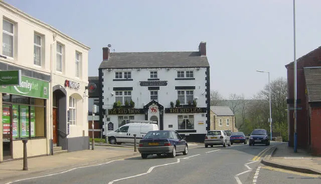
Lees village centre, in Greater Manchester, England.
Looking eastwards along the A669 at Lees, near Oldham, towards County End, with the Red Lion pub on the corner.
Stamford Road, Lees
Lees Road
Photo by Martin Clark
Destinations
Home›Destinations›Lees
EuropeUnited KingdomEngland

Lees

England, United Kingdom · Europe

About Lees

Lees works well as a base: 5 minutes from Mossley, 17km from Snake Pass (A57).

Lees is in England, United Kingdom, with about 13,000 people. You drive on the left here. The nearest town is Mossley, about 4 km away.

Where to Stay in Lees

Compare prices across Booking.com, Airbnb, Expedia, and more. Select your dates to see availability.

Filter presets

Pick your must-haves once: provider links open pre-filtered. Each filter lists which sites it applies to.

Booking.comExpediaTripAdvisorHotels.comAgodaAirbnb

Compare before you book!

Prices can vary significantly between platforms. We recommend checking at least 2-3 sites to find the best deal for your stay in Lees.

Explore the Area

Discover famous landmarks, scenic roads, and more near Lees.

Loading map...
Open in Google Maps

Frequently Asked Questions

What is there to see near Lees?

Within an hour or so of Lees: Rapha Clubhouse Manchester (12 km), Holme Moss (14 km), Woodhead Pass (15 km), Snake Pass (A57) (17 km).

Are there any good drives near Lees?

The nearest famous roads are Holme Moss, Woodhead Pass and Snake Pass.

Where is Lees?

Lees is in England, United Kingdom, about 4 km from Mossley.

Road trip

Drive to Lees

Add it as a stop and the planner works out the driving, the nights and what's worth seeing on the way.

Start planning

What's nearby?

Swipe through places to go

Places within a drive of Lees. Keep the ones you like and add them to your trip.

Explore now

Quick Information

Population
12,630
Continent
Europe
Country
United Kingdom
Region
England
Timezone
Europe/London
Coordinates
53.5379, -2.0730

Emergency & Services

Essential numbers in United Kingdom

Police
999
Ambulance
999
Fire
999
Non-emergency police
101
Driving side
left

112 also works. NHS non-emergency medical advice: 111. National Highways breakdown assistance on motorways: 0300 123 5000.

Full driving guide for United Kingdom

Tags

EuropeUnited KingdomEnglandTown

Worth the detour from Lees

8 notable places within an hour's drive.

cafe

Rapha Clubhouse Manchester

Manchester's cycling culture hub offering specialty coffee, kit, and a community space for riding enthusiasts.

12 km · about 25 min drive

mountain pass

Holme Moss

A 524 m Pennine pass on the A6024 topped by a landmark transmitter mast, a celebrated cycling climb used in the 2014 Tour de France.

14 km · about 25 min drive

mountain pass

Woodhead Pass

The A628 trans-Pennine route over bleak moorland past the Woodhead reservoirs, frequently closed by snow and high winds.

15 km · about 30 min drive

famous road

Snake Pass (A57)

The Woodhead-era Telford road over the Pennines between Glossop and the Ladybower reservoirs, with fast curves and frequent winter closures.

17 km · about 20 min drive

famous road

Snake Pass

A twisting road through the Peak District connecting Sheffield and Manchester, beloved by motorcyclists and driving enthusiasts.

18 km · about 20 min drive

scenic viewpoint

Snake Pass Summit

The highest point on the A57 crossing the Pennines, with moorland views stretching across the Dark Peak landscape.

18 km · about 20 min drive

waterfall

Kinder Downfall

The Peak's highest waterfall at 30m, famously blown back up the cliff as spray in a westerly wind.

20 km · about 25 min drive

film location

Lyme Park (Pemberley, 1995 Pride and Prejudice)

The lake at Lyme Park is where Colin Firth's Mr Darcy emerges from the water in the BBC serial.

22 km · about 25 min drive

Driving roads near Lees

9 named roads, passes and coastal drives within 60km.

  • Right hereHolme MossA 524 m Pennine pass on the A6024 topped by a landmark transmitter mast, a celebrated cycling climb used in the 2014 Tour de France.
  • Right hereWoodhead PassThe A628 trans-Pennine route over bleak moorland past the Woodhead reservoirs, frequently closed by snow and high winds.
  • 17 kmSnake Pass (A57)The Woodhead-era Telford road over the Pennines between Glossop and the Ladybower reservoirs, with fast curves and frequent winter closures.
  • 18 kmSnake PassA twisting road through the Peak District connecting Sheffield and Manchester, beloved by motorcyclists and driving enthusiasts.
  • 18 kmSnake Pass SummitThe highest point on the A57 crossing the Pennines, with moorland views stretching across the Dark Peak landscape.
  • 22 kmKinder ScoutThe Peak District's highest ground at 636m, site of the 1932 Mass Trespass that led to Britain's national parks and right to roam.

Driving in United Kingdom

Drives on
the left
Petrol
~€1.73/litre
Motorway tolls
None

When to drive here

April to October

Nearby Destinations

Other places to explore near Lees.

Oldham

🇬🇧 United Kingdom

3 km awayPop. 237,110

Shaw

🇬🇧 United Kingdom

3 km awayPop. 1,001

Mossley

🇬🇧 United Kingdom

4 km awayPop. 9,929

Dobcross

🇬🇧 United Kingdom

4 km awayPop. 1,567

Royton

🇬🇧 United Kingdom

4 km awayPop. 22,848

Chadderton

🇬🇧 United Kingdom

4 km awayPop. 37,602

Uppermill

🇬🇧 United Kingdom

5 km awayPop. 11,191

Saddleworth

🇬🇧 United Kingdom

5 km awayPop. 25,441

Plan a trip around Lees

United Kingdom road trip planner

Your trip starts here

Plan a road trip from Lees.

Pick the days, drop in the stops, and share it with whoever's coming.

Start planning
PYRT

The ultimate road trip planning platform. Discover 150,000+ destinations worldwide, plan scenic routes, and create unforgettable adventures.

Inspiration

  • Discover Trips
  • Travel Guides
  • Community

The Product

  • Calendar Planner
  • Integrations
  • How It Works
  • Collaboration Mode
  • Get the App
  • Merchandise: PYRT Supply Co.
  • Become a Creator
  • Trip Marketplace

Plan Your Trip

  • Road Trip Planner
  • Famous Routes
  • Drive Times & Distances
  • Planners by Country
  • Best Road Trip Planner App
  • Discover Road Trips
  • Events
  • Travel Guides
  • How It Works
  • My Trips
  • Community Groups

Company

  • Terms of Service
  • Privacy Policy
  • About PYRT
  • Support
  • Contact Us
  • Sign In
  • Create Account

© 2026 Plan Your Road Trips. All rights reserved.

•[email protected]
Data sources:GeoNames (CC BY 4.0)•Wikimedia Commons (CC BY-SA)•Mapbox•Photography: George Lawrence