

waterfall
Powerscourt Waterfall
Ireland's highest waterfall at 121 metres, cascading down a rock face in the beautiful Powerscourt Estate in the Wicklow Mountains.
11 km · about 20 min drive
Leinster, Ireland · Europe
Kilcoole works well as a base: 10 minutes from Greystones, 21km from Glendalough Upper Lake.
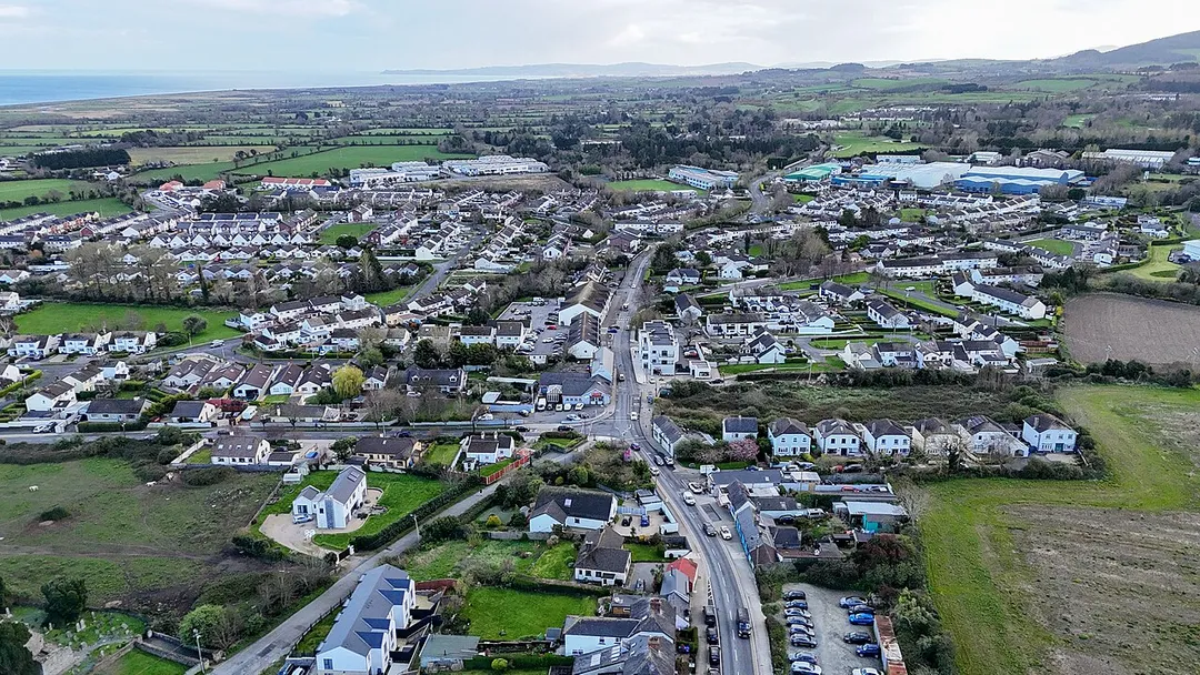
Kilcoole is in Leinster, Ireland, with about 4,200 people. You drive on the left here. The nearest town is Greystones, about 4 km away.
Kilcoole (Irish: Cill Chomhghaill, meaning 'church of Comhghall') is a town in County Wicklow, Ireland. It is 3 kilometres (2 mi) south of Greystones, 14 km (9 mi) north of Wicklow, and about 28 km (17 mi) south of Dublin. The town is in a townland and civil parish of the same name. Kilcoole was used as a filmingRead more
location for the Irish television series Glenroe, which ran through the 1980s and 1990s.
The town has a large industrial estate to the south. An area of marshland runs along the coast from Kilcoole south to Wicklow town, called the Murragh. This area is home to many endangered species of plants and animals. The nearby beach is the summertime home of the little tern, one of the few places in Ireland where these birds nest. Within Kilcoole, is an area of flora known as the Rock which is a huge rock/hill that predates the Cambrian Period.
Kilcoole is in the Roman Catholic parish of Kilquade and the local church, St. Anthony's Church, was opened in 1968.
Compare prices across Booking.com, Airbnb, Expedia, and more. Select your dates to see availability.
Pick your must-haves once: provider links open pre-filtered. Each filter lists which sites it applies to.
Compare before you book!
Prices can vary significantly between platforms. We recommend checking at least 2-3 sites to find the best deal for your stay in Kilcoole.
Discover famous landmarks, scenic roads, and more near Kilcoole.
Within an hour or so of Kilcoole: Powerscourt Waterfall (11 km), Lough Tay (Guinness Lake) (13 km), Sally Gap (17 km), Glenmacnass Waterfall (19 km).
The nearest famous roads are Sally Gap, Wicklow Gap and A4085 Beddgelert to Caernarfon.
Kilcoole is in Leinster, Ireland, about 4 km from Greystones.
Road trip
Add it as a stop and the planner works out the driving, the nights and what's worth seeing on the way.
Start planningSwipe through places to go
Places within a drive of Kilcoole. Keep the ones you like and add them to your trip.
8 notable places within an hour's drive.
waterfall
Ireland's highest waterfall at 121 metres, cascading down a rock face in the beautiful Powerscourt Estate in the Wicklow Mountains.
11 km · about 20 min drive
scenic viewpoint
A dark lake with a pale sand beach at one end, viewed from the R759 above; used as the Viking village in the series Vikings.
13 km · about 25 min drive
mountain pass
A high crossroads pass over the Wicklow Mountains amid blanket bog, with the famous Military Road running through.
17 km · about 20 min drive
waterfall
A waterfall spilling off the plateau beside the Military Road in the Wicklow Mountains, with parking right at the top.
19 km · about 20 min drive
ancient ruins
Atmospheric early medieval monastic settlement in a glacial valley in the Wicklow Mountains, with round tower, stone churches and tranquil lakes.
20 km · about 25 min drive
natural wonder
The upper of Glendalough's two lakes, ringed by cliffs and mine ruins at the head of the valley — quieter than the monastic city.
21 km · about 25 min drive
scenic viewpoint
A boardwalk ridge walk high above the Upper Lake at Glendalough, climbing beside the Poulanass waterfall.
21 km · about 25 min drive
mountain pass
High mountain pass on the R756 across the Wicklow Mountains between Hollywood and Glendalough, following the medieval pilgrims' route of St Kevin's Road through wild granite moorland.
23 km · about 25 min drive
9 named roads, passes and coastal drives within 150km.
April to October
Other places to explore near Kilcoole.
Your trip starts here
Pick the days, drop in the stops, and share it with whoever's coming.