PYRTPlan Your Road Trips
Create TripCommunityMerchandise
PYRTPlan Your Road Trips
Create TripCommunityMerchandise
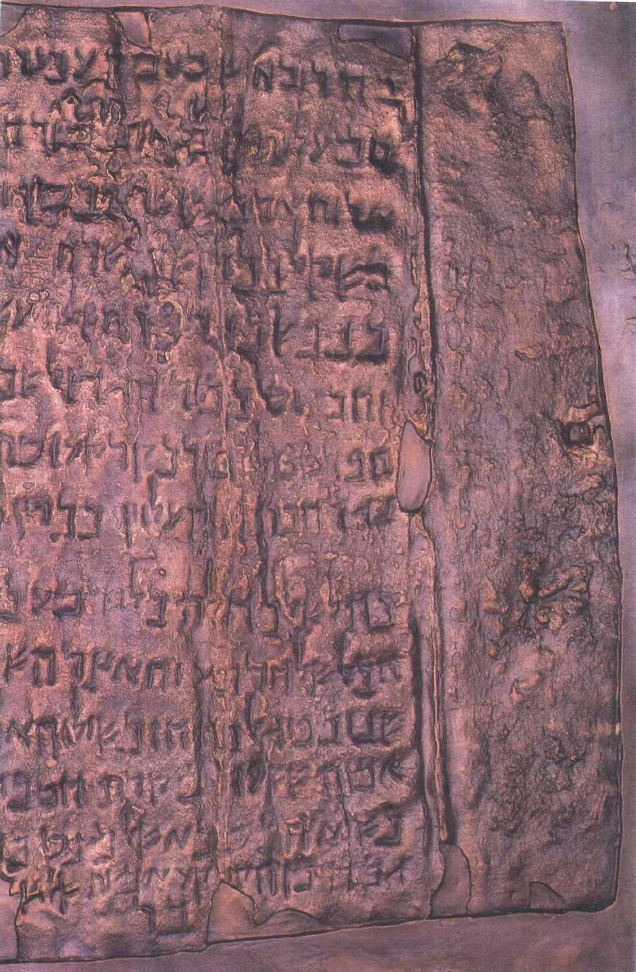
Part of Qumran Copper Scroll.
Strip 11, part of the Copper Dear Sea Scrolls. Discovered Cave Q3 at Qumran, this is the only known inscription on metal from the Dead Sea Scrolls. This scroll consisted of 3 sheets, totaling 230 cm in length. They were rolled up and had to into 23 strips for scholars to read their content, which was written in the Hebrew Mishnaic dialect. Roman period, 1st century CE. From Qumran (Khirbet Qumran or Wadi Qumran), West Bank of the Jordan River, near the Dead Sea, modern-day State of Israel. On display at the Jordan Museum in Amman, the Hashemite Kingdom of Jordan.
Photo by na
Destinations
Home›Destinations›Khallat ad Dār
AsiaPalestineWest Bank

Khallat ad Dār

West Bank, Palestine · Asia

About Khallat ad Dār

Khallat ad Dār is worth a stop: 10 minutes from Hebron, 26km from Ein Gedi Nature Reserve.

Khallat ad Dār is in West Bank, Palestine, with about 2,200 people. The nearest town is Hebron, about 4 km away.

Where to Stay in Khallat ad Dār

Compare prices across Booking.com, Airbnb, Expedia, and more. Select your dates to see availability.

Filter presets

Pick your must-haves once: provider links open pre-filtered. Each filter lists which sites it applies to.

Booking.comExpediaTripAdvisorHotels.comAgodaAirbnb

Compare before you book!

Prices can vary significantly between platforms. We recommend checking at least 2-3 sites to find the best deal for your stay in Khallat ad Dār.

Explore the Area

Discover famous landmarks, scenic roads, and more near Khallat ad Dār.

Loading map...
Open in Google Maps

Frequently Asked Questions

What is there to see near Khallat ad Dār?

Within an hour or so of Khallat ad Dār: Church of the Nativity (25 km), Ein Gedi Nature Reserve (26 km), Masada (30 km), Yad Vashem (31 km).

Are there any good drives near Khallat ad Dār?

The nearest famous roads are King's Highway, Scorpions Ascent (Ma'ale Akrabim) and Dana to Petra Trail.

Where is Khallat ad Dār?

Khallat ad Dār is in West Bank, Palestine, about 4 km from Hebron.

Road trip

Drive to Khallat ad Dār

Add it as a stop and the planner works out the driving, the nights and what's worth seeing on the way.

Start planning

What's nearby?

Swipe through places to go

Places within a drive of Khallat ad Dār. Keep the ones you like and add them to your trip.

Explore now

Quick Information

Population
2,153
Continent
Asia
Country
Palestine
Region
West Bank
Timezone
Asia/Hebron
Coordinates
31.4974, 35.1136

Tags

AsiaPalestineWest BankTown

Worth the detour from Khallat ad Dār

8 notable places within an hour's drive.

cathedral

Church of the Nativity

One of the oldest continuously operating churches in the world, built over the traditional birthplace of Jesus.

25 km · about 30 min drive

natural wonder

Ein Gedi Nature Reserve

A lush oasis of waterfalls, pools, and wildlife on the shores of the Dead Sea in the Judean Desert.

26 km · about 30 min drive

ancient ruins

Masada

An ancient Roman fortress atop an isolated rock plateau overlooking the Dead Sea, site of the last Jewish stand against Rome in 73 CE.

30 km · about 35 min drive

museum

Yad Vashem

Israel's official memorial to the Holocaust, with deeply moving exhibits and a striking modernist museum built into a mountainside.

31 km · about 35 min drive

cathedral

Church of the Holy Sepulchre

Christianity's holiest site, built on the traditional locations of Jesus's crucifixion and burial.

33 km · about 40 min drive

landmark

Jerusalem Old City

A walled sacred city of one square kilometer containing holy sites for Judaism, Christianity, and Islam within four historic quarters.

33 km · about 40 min drive

landmark

Western Wall (Wailing Wall)

The holiest site where Jews can pray, a 2,000-year-old limestone remnant of the Second Temple retaining wall in the Old City of Jerusalem.

33 km · about 40 min drive

landmark

Dome of the Rock

The iconic gold-domed Islamic shrine on the Temple Mount/Haram al-Sharif, built in 691 CE over the sacred Foundation Stone.

33 km · about 40 min drive

Driving roads near Khallat ad Dār

3 named roads, passes and coastal drives within 150km.

  • 66 kmKing's HighwayOne of the world's oldest continuously used routes, winding 280 km from Madaba to Petra past Karak's crusader castle, Dana's cliffs and the mighty Wadi Mujib canyon.
  • 67 kmScorpions Ascent (Ma'ale Akrabim)A serpentine 1950s road built over an ancient Nabataean-Roman trade route, snaking down the Negev cliffs toward the Arava with dizzying desert switchbacks.

Nearby Destinations

Other places to explore near Khallat ad Dār.

Hebron

🇵🇸 Palestine

4 km awayPop. 160,470

Banī Na‘īm

🇵🇸 Palestine

5 km awayPop. 19,783

Yaţţā

🇵🇸 Palestine

6 km awayPop. 41,425

Taffūḩ

🇵🇸 Palestine

8 km awayPop. 9,480

Dūrā

🇵🇸 Palestine

8 km awayPop. 20,835

Ash Shuyūkh

🇵🇸 Palestine

9 km awayPop. 8,151

Ḩalḩūl

🇵🇸 Palestine

9 km awayPop. 21,076

Sa‘īr

🇵🇸 Palestine

9 km awayPop. 17,775

Plan a trip around Khallat ad Dār

Asia road trip planner

Your trip starts here

Plan a road trip from Khallat ad Dār.

Pick the days, drop in the stops, and share it with whoever's coming.

Start planning
PYRT

The ultimate road trip planning platform. Discover 150,000+ destinations worldwide, plan scenic routes, and create unforgettable adventures.

Inspiration

  • Discover Trips
  • Travel Guides
  • Community

The Product

  • Calendar Planner
  • Integrations
  • How It Works
  • Collaboration Mode
  • Get the App
  • Merchandise: PYRT Supply Co.
  • Become a Creator
  • Trip Marketplace

Plan Your Trip

  • Road Trip Planner
  • Famous Routes
  • Drive Times & Distances
  • Planners by Country
  • Best Road Trip Planner App
  • Discover Road Trips
  • Events
  • Travel Guides
  • How It Works
  • My Trips
  • Community Groups

Company

  • Terms of Service
  • Privacy Policy
  • About PYRT
  • Support
  • Contact Us
  • Sign In
  • Create Account

© 2026 Plan Your Road Trips. All rights reserved.

•[email protected]
Data sources:GeoNames (CC BY 4.0)•Wikimedia Commons (CC BY-SA)•Mapbox•Photography: George Lawrence