PYRTPlan Your Road Trips
Create TripCommunityMerchandise
PYRTPlan Your Road Trips
Create TripCommunityMerchandise
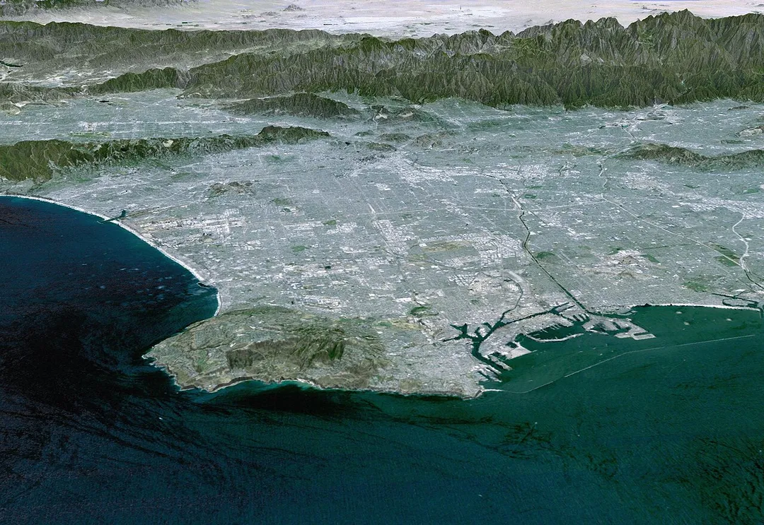
3-D Perspective image of the Los Angeles Basin from the Landsat satellite using NASA's Shuttle Radar Topography Mission (SRTM) for topography information. The vertical scale is exaggerated one and half times.
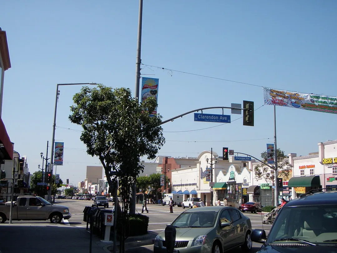
This is a photograph of the intersection of Pacific Boulevard and Clarendon Avenue in Huntington Park, California on a Saturday morning in August of 2009.
Looking north on Pacific Boulevard, Huntington Park, southern California, 1907
Photograph of the view looking north on Pacific Boulevard (or Long Beach Avenue?), Huntington Park, southern California, 21 March 1907. A few 2-story commercial brick buildings are situated on either side of the dirt street which is puddled from rain. A horse-drawn wagon and a man are visible in the street. A few other pedestrians are in the street near some railroad tracks. Houses sparsely dot a residential area in the background. Legible signs include: "Huntington..., "Groveland", "Railroad crossing".
Call number: CHS-5001
Filename: CHS-5001
Coverage date: 1907-03-21
Part of collection: California Historical Society Collection, 1860-1960
Format: glass plate negatives
Type: images
Geographic subject (city or populated place): Huntington Park; Huntington Park
Repository name: USC Libraries Special Collections
Accession number: 5001
Archival file: chs_Volume51/CHS-5001.tiff
Part of subcollection: Title Insurance and Trust, and C.C. Pierce Photography Collection, 1860-1960
Repository address: Doheny Memorial Library, Los Angeles, CA 90089-0189
Geographic subject (country): USA
Format (aacr2): 2 photographs : glass photonegative, photonegative, b&w ; 21 x 26 cm.; 1 photograph : photoprint, b&w ; 21 x 26 cm.
Rights: Digitally reproduced by the USC Digital Library; From the California Historical Society Collection at the University of Southern California
Subject (adlf): roadways
Project: USC
Repository email: specol@usc.edu
Contributing entity: California Historical Society
Date created: 1907-03-21
Publisher (of the digital version): University of Southern California. Libraries
Format (aat): negatives (photographic); photographs
Geographic subject (state): California
Subject (file heading): Huntington Park
Legacy record ID: chs-m5730; USC-1-1-1-5850
Access conditions: Send requests to address or e-mail given. Phone (213) 821-2366; fax (213) 740-2343.
Geographic subject (county): Los Angeles
Geographic subject (roadway): Pacific Boulevard; Long Beach Avenue, looking north
Subject (lcsh): Retail trade
Photo by This image uses high-resolution digital topography data from NASA's Shuttle Radar Topography Mission (SRTM) at JPL-Caltech [1]. It is in the public domain in the United States.
Destinations
Home›Destinations›Huntington Park
North AmericaUnited StatesCalifornia

Huntington Park

California, United States · North America

About Huntington Park

Huntington Park works well as a base: 5 minutes from Bell, 15km from Petersen Automotive Museum.

Huntington Park is in California, United States, with about 59,000 people. You drive on the right here. The nearest town is Bell, about 4 km away.

Where to Stay in Huntington Park

Compare prices across Booking.com, Airbnb, Expedia, and more. Select your dates to see availability.

Filter presets

Pick your must-haves once: provider links open pre-filtered. Each filter lists which sites it applies to.

Booking.comExpediaTripAdvisorHotels.comAgodaAirbnb

Compare before you book!

Prices can vary significantly between platforms. We recommend checking at least 2-3 sites to find the best deal for your stay in Huntington Park.

Explore the Area

Discover famous landmarks, scenic roads, and more near Huntington Park.

Loading map...
Open in Google Maps

Frequently Asked Questions

What is there to see near Huntington Park?

Within an hour or so of Huntington Park: Cole's Pacific Electric Buffet (7 km), The Original Pantry Cafe (8 km), Philippe the Original (9 km), Petersen Automotive Museum (15 km).

Are there any good drives near Huntington Park?

The nearest famous roads are Mulholland Drive and Route 66 - Santa Monica End.

Where is Huntington Park?

Huntington Park is in California, United States, about 4 km from Bell.

Road trip

Drive to Huntington Park

Add it as a stop and the planner works out the driving, the nights and what's worth seeing on the way.

Start planning

What's nearby?

Swipe through places to go

Places within a drive of Huntington Park. Keep the ones you like and add them to your trip.

Explore now

Quick Information

Population
59,430
Continent
North America
Country
United States
Region
California
Timezone
America/Los_Angeles
Coordinates
33.9817, -118.2251

Emergency & Services

Essential numbers in United States

Police
911
Ambulance
911
Fire
911
Driving side
right

AAA roadside assistance: 1-800-222-4357. Right turn on red is legal in most states unless signed otherwise.

Full driving guide for United States

Tags

North AmericaUnited StatesCaliforniaTown

Worth the detour from Huntington Park

8 notable places within an hour's drive.

restaurant

Cole's Pacific Electric Buffet

Open since 1908 in the old Pacific Electric building, with a penny-tile floor, original mahogany bar and a rival claim to the French dip. A hidden speakeasy bar sits behind an unmarked door.

7 km · about 15 min drive

cafe

The Original Pantry Cafe

A downtown Los Angeles counter-and-booth diner that has served 24 hours a day since 1924 and famously has no lock on the front door. Cash-only, enormous portions, sourdough on every table.

8 km · about 15 min drive

restaurant

Philippe the Original

Serving French dip sandwiches since 1908 on sawdust-covered floors with communal tables and long wooden counters. One of Los Angeles's oldest restaurants and a claimant to inventing the French dip.

9 km · about 15 min drive

museum

Petersen Automotive Museum

LA's premier car museum with a striking stainless-steel facade, showcasing the artistry and cultural impact of the automobile.

15 km · about 30 min drive

cafe

Tail o' the Pup

A 17-foot hot dog stand shaped like a hot dog in a bun, built in 1946, dismantled in 2005 and painstakingly restored to a new West Hollywood site in 2022. A landmark of Californian programmatic architecture.

18 km · about 20 min drive

landmark

Hollywood Sign

Iconic 14-metre-tall white lettering on Mount Lee in the Santa Monica Mountains, the universal symbol of the entertainment industry.

19 km · about 20 min drive

landmark

Universal Studios Hollywood

The original Universal theme park and working film studio offering studio tours and movie-based attractions.

21 km · about 25 min drive

cafe

Deus Ex Machina Los Angeles

The Venice Beach location of Deus combining California motorcycle culture with specialty coffee and custom builds.

21 km · about 25 min drive

Driving roads near Huntington Park

  • 25 kmMulholland DriveWinding road through the Santa Monica Mountains with LA city views
  • 25 kmRoute 66 - Santa Monica EndThe 'End of the Trail' sign on Santa Monica Pier marks Route 66's symbolic Pacific terminus, 2,448 miles from Chicago, beside the pier's vintage carousel and Ferris wheel.
Nearby Destinations

Other places to explore near Huntington Park.

Florence-Graham

🇺🇸 United States

2 km awayPop. 63,387

South Gate

🇺🇸 United States

3 km awayPop. 96,401

Bell

🇺🇸 United States

4 km awayPop. 36,205

Maywood

🇺🇸 United States

4 km awayPop. 27,888

Cudahy

🇺🇸 United States

4 km awayPop. 24,311

Lynwood

🇺🇸 United States

6 km awayPop. 71,989

Boyle Heights

🇺🇸 United States

6 km awayPop. 92,785

Commerce

🇺🇸 United States

6 km awayPop. 13,081

Plan a trip around Huntington Park

North America road trip planner

Your trip starts here

Plan a road trip from Huntington Park.

Pick the days, drop in the stops, and share it with whoever's coming.

Start planning
PYRT

The ultimate road trip planning platform. Discover 150,000+ destinations worldwide, plan scenic routes, and create unforgettable adventures.

Inspiration

  • Discover Trips
  • Travel Guides
  • Community

The Product

  • Calendar Planner
  • Integrations
  • How It Works
  • Collaboration Mode
  • Get the App
  • Merchandise: PYRT Supply Co.
  • Become a Creator
  • Trip Marketplace

Plan Your Trip

  • Road Trip Planner
  • Famous Routes
  • Drive Times & Distances
  • Planners by Country
  • Best Road Trip Planner App
  • Discover Road Trips
  • Events
  • Travel Guides
  • How It Works
  • My Trips
  • Community Groups

Company

  • Terms of Service
  • Privacy Policy
  • About PYRT
  • Support
  • Contact Us
  • Sign In
  • Create Account

© 2026 Plan Your Road Trips. All rights reserved.

•[email protected]
Data sources:GeoNames (CC BY 4.0)•Wikimedia Commons (CC BY-SA)•Mapbox•Photography: George Lawrence