

natural wonder
Vixen Tor
One of Dartmoor's tallest tors at around 30 m, on private land near Merrivale and long the subject of an access dispute.
5 km · about 10 min drive
England, United Kingdom · Europe
Horrabridge works well as a base: 10 minutes from Tavistock, 5km from Vixen Tor.
Horrabridge is in England, United Kingdom, with about 3,700 people. You drive on the left here. The nearest town is Tavistock, about 6 km away.
Horrabridge is a village and civil parish in the West Devon district, in Devon, England. The village lies approximately 12 miles (19 km) north of the city of Plymouth and 4 miles (6.4 km) south of Tavistock, and is within the Dartmoor National Park. In 2021 the parish had a population of 2,199.
The village sits on theRead more
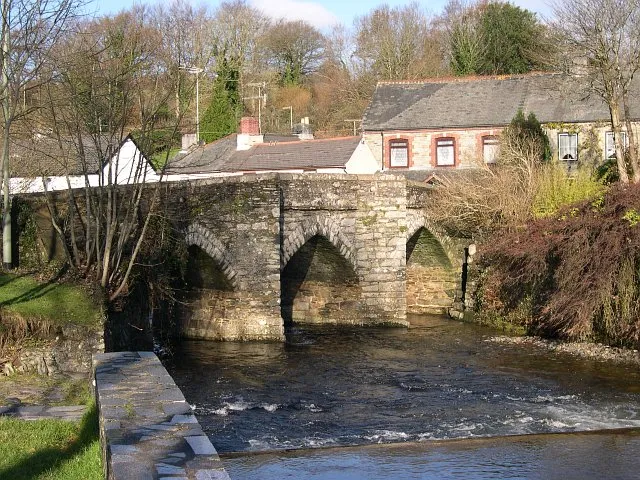
River Walkham, a fishing river famous for its salmon. The village's name may have been taken from the 15th-century packhorse bridge which remains the only vehicular route from one side of the village to the other, and featured in the children's television programme Bagpuss. The bridge is a Grade I listed structure.
Horrabridge has two pubs, the London Inn and The Leaping Salmon, but has lost many of its shops over the last 20 years including a draper, television shop and a general store. The village does however retain its post office, family bakery, hairdresser, florist and newsagent.
Until the beginning of the 20th century, the main industry was the mining of copper and tin. This industry has completely disappeared, leaving a legacy of unmapped mineshafts in the village and the surrounding area. It is a popular starting point for walks on Dartmoor and has become a dormitory village for the adjoining towns.
Compare prices across Booking.com, Airbnb, Expedia, and more. Select your dates to see availability.
Pick your must-haves once: provider links open pre-filtered. Each filter lists which sites it applies to.
Compare before you book!
Prices can vary significantly between platforms. We recommend checking at least 2-3 sites to find the best deal for your stay in Horrabridge.
Discover famous landmarks, scenic roads, and more near Horrabridge.
Within an hour or so of Horrabridge: Vixen Tor (5 km), Burrator Reservoir (5 km), Wistman's Wood (12 km), B3212 across Dartmoor (14 km).
The nearest famous roads are B3212 across Dartmoor, Atlantic Highway (A39) and A39 Atlantic Highway (Barnstaple to Bude).
Horrabridge is in England, United Kingdom, about 6 km from Tavistock.
Road trip
Add it as a stop and the planner works out the driving, the nights and what's worth seeing on the way.
Start planningSwipe through places to go
Places within a drive of Horrabridge. Keep the ones you like and add them to your trip.
Essential numbers in United Kingdom
112 also works. NHS non-emergency medical advice: 111. National Highways breakdown assistance on motorways: 0300 123 5000.
Full driving guide for United Kingdom8 notable places within an hour's drive.
natural wonder
One of Dartmoor's tallest tors at around 30 m, on private land near Merrivale and long the subject of an access dispute.
5 km · about 10 min drive
natural wonder
A wooded reservoir on the south-western edge of Dartmoor, encircled by a narrow lane popular with cyclists.
5 km · about 10 min drive
natural wonder
Stunted, moss-drowned oaks growing between granite boulders form one of Britain's last high-altitude temperate rainforests, long linked with Druid legend. A 20-minute walk from the Two Bridges car park on Dartmoor.
12 km · about 25 min drive
famous road
The open moorland crossing from Moretonhampstead to Yelverton past Postbridge and Princetown, with ponies on the road.
14 km · about 25 min drive
national park
Wild and ancient moorland dotted with granite tors, Bronze Age settlements and roaming Dartmoor ponies across 368 square miles of Devon.
15 km · about 25 min drive
landmark
The UK's largest aquarium in Plymouth dedicated to ocean conservation with Atlantic Ocean and deep reef exhibits.
16 km · about 30 min drive
natural wonder
A conifer plantation on the East Dart with Bronze Age hut circles, a clapper bridge and easy riverside walks.
16 km · about 20 min drive
bridge
A 13th-century granite slab bridge over the East Dart, the best-preserved clapper bridge on Dartmoor.
16 km · about 20 min drive
April to October
Other places to explore near Horrabridge.
Your trip starts here
Pick the days, drop in the stops, and share it with whoever's coming.