PYRTPlan Your Road Trips
Create TripCommunityMerchandise
PYRTPlan Your Road Trips
Create TripCommunityMerchandise
Claremorris, County Mayo, Ireland
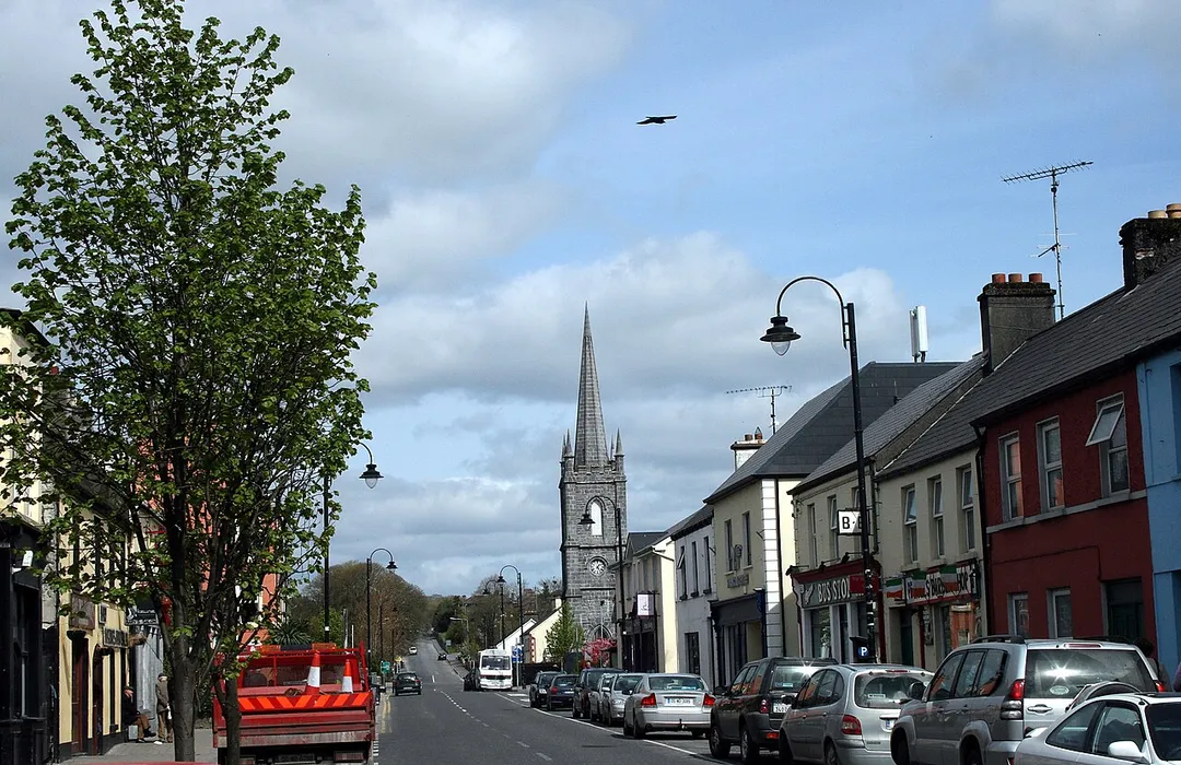
Busy part of Claremorris
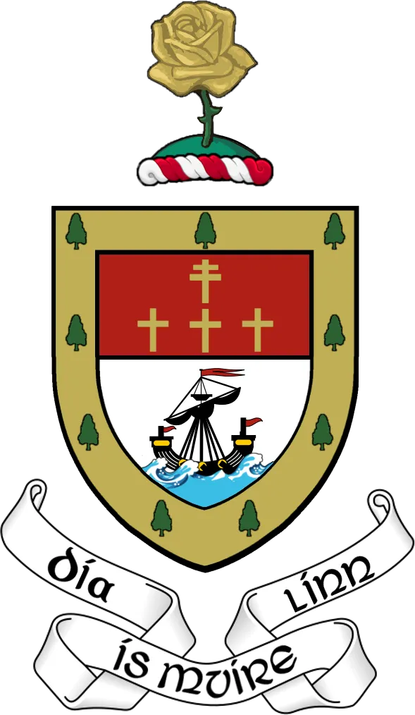
Digital recreation of The Coat of Arms ("crest") of County Mayo in the Republic of Ireland, based on the following official description:
"Per fess gules and argent in chief four crosses one and three the first patriarchal the others passion crosses or, in base on waves of the sea a lymphad proper, the whole within a bordure of the third charged with nine yew trees also proper, with the Crest: On a mount vert a garden rose slipped or and with the Motto: Dia is Muire linn."
Photo by Original author and uploader was Sarah777 at en.wikipedia
Destinations
Home›Destinations›Claremorris
EuropeIrelandConnacht

Claremorris

Connacht, Ireland · Europe

About Claremorris

Claremorris sits on the route: 30 minutes from Kiltamagh, 52km from Killary Harbour.

Claremorris is in Connacht, Ireland, with about 3,700 people. You drive on the left here. The nearest town is Kiltamagh, about 15 km away.

Claremorris (; Irish: Clár Chlainne Mhuiris) is a town in County Mayo in the west of Ireland, at the junction of the N17 and the N60 national routes. As of the 2017, it was the fastest growing town in the county, having seen a 31% increase in population between 2006 and 2011, and a 23% increase between 2002 and 2006.

Read more Between the 2016 census and the 2022 census, the population of Claremorris grew further, from 3,687 to 3,857 inhabitants. The town sits at the bottom of a valley, all roads leading to the town follow hills, in particular the old Knock road (known as the Knock hill) and Courthouse road. Although low-lying, the town does not experience flooding. There is no major river through the town although there are two lakes in the town centre: Clare Lough where the 'Land of the Giants' amenity is located and Mayfield Lough. A small river flows between the two.

Read more on Wikipedia

Where to Stay in Claremorris

Compare prices across Booking.com, Airbnb, Expedia, and more. Select your dates to see availability.

Filter presets

Pick your must-haves once: provider links open pre-filtered. Each filter lists which sites it applies to.

Booking.comExpediaTripAdvisorHotels.comAgodaAirbnb

Compare before you book!

Prices can vary significantly between platforms. We recommend checking at least 2-3 sites to find the best deal for your stay in Claremorris.

Explore the Area

Discover famous landmarks, scenic roads, and more near Claremorris.

Loading map...
Open in Google Maps

Frequently Asked Questions

What is there to see near Claremorris?

Within an hour or so of Claremorris: Croagh Patrick (44 km), Aasleagh Falls (45 km), Wild Atlantic Way (50 km), Killary Harbour (52 km).

Are there any good drives near Claremorris?

The nearest famous roads are Wild Atlantic Way, Achill Atlantic Drive and Corkscrew Hill.

Where is Claremorris?

Claremorris is in Connacht, Ireland, about 15 km from Kiltamagh.

Road trip

Drive to Claremorris

Add it as a stop and the planner works out the driving, the nights and what's worth seeing on the way.

Start planning

What's nearby?

Swipe through places to go

Places within a drive of Claremorris. Keep the ones you like and add them to your trip.

Explore now

Quick Information

Population
3,687
Continent
Europe
Country
Ireland
Region
Connacht
Timezone
Europe/Dublin
Coordinates
53.7167, -9.0000

Emergency & Services

Essential numbers in Ireland

Police
999
Ambulance
999
Fire
999
All emergencies
112
Driving side
left
Full driving guide for Ireland

Tags

EuropeIrelandConnachtTown

Worth the detour from Claremorris

8 notable places within an hour's drive.

scenic viewpoint

Croagh Patrick

Ireland's holiest mountain at 764 metres, where St Patrick is said to have fasted for 40 days, with sweeping views over Clew Bay.

44 km · about 50 min drive

waterfall

Aasleagh Falls

A broad low waterfall on the Erriff River near the head of Killary Harbour, a short walk from a roadside car park.

45 km · about 50 min drive

coastal drive

Wild Atlantic Way

2,500 km coastal route along Ireland's rugged western seaboard

50 km · about 55 min drive

natural wonder

Killary Harbour

Ireland's only true fjord, a 16km glacial inlet flanked by mountains on the Galway-Mayo border.

52 km · about 60 min drive

scenic viewpoint

Doolough Valley

Brooding mountain pass on the R335 between Louisburgh and Delphi where dark Doo Lough fills the valley floor between Mweelrea and the Sheeffry Hills. A stone cross remembers the 1849 Famine death march along this road.

52 km · about 60 min drive

scenic viewpoint

Lough Inagh Valley

A glacial valley on the R344 in Connemara with a long lake wedged between the Twelve Bens and the Maumturks.

54 km · about 60 min drive

scenic viewpoint

Derryclare Lough

The Connemara lake with the much-photographed pine-covered islet, seen from a lay-by on the N59 near Recess.

56 km · about 65 min drive

cafe

Moran's Oyster Cottage

A thatched cottage restaurant on the shore of Kilcolgan estuary serving fresh oysters since 1760, a legendary detour on Ireland's Wild Atlantic Way.

57 km · about 65 min drive

Driving roads near Claremorris

  • 44 kmCroagh PatrickIreland's holiest mountain at 764 metres, where St Patrick is said to have fasted for 40 days, with sweeping views over Clew Bay.
  • 50 kmWild Atlantic Way2,500 km coastal route along Ireland's rugged western seaboard
  • 52 kmDoolough ValleyBrooding mountain pass on the R335 between Louisburgh and Delphi where dark Doo Lough fills the valley floor between Mweelrea and the Sheeffry Hills. A stone cross remembers the 1849 Famine death march along this road.
  • 54 kmLough Inagh ValleyA glacial valley on the R344 in Connemara with a long lake wedged between the Twelve Bens and the Maumturks.
  • 56 kmDerryclare LoughThe Connemara lake with the much-photographed pine-covered islet, seen from a lay-by on the N59 near Recess.
  • 65 kmDiamond HillA quartzite peak in Connemara National Park whose looped trail rewards walkers with sweeping coast and mountain views.

Driving in Ireland

Drives on
the left
Petrol
~€1.78/litre
Motorway tolls
~€2.10/100km

When to drive here

April to October

Nearby Destinations

Other places to explore near Claremorris.

Tuam

🇮🇪 Ireland

24 km awayPop. 9,647

Castlebar

🇮🇪 Ireland

25 km awayPop. 12,874

Toormakeady

🇮🇪 Ireland

25 km awayPop. 1,007

Foxford

🇮🇪 Ireland

30 km awayPop. 1,315

Moycullen

🇮🇪 Ireland

44 km awayPop. 1,704

Ballina

🇮🇪 Ireland

46 km awayPop. 10,087

Galway

🇮🇪 Ireland

50 km awayPop. 83,456

Loughrea

🇮🇪 Ireland

65 km awayPop. 5,556

Plan a trip around Claremorris

Ireland road trip planner

Your trip starts here

Plan a road trip from Claremorris.

Pick the days, drop in the stops, and share it with whoever's coming.

Start planning
PYRT

The ultimate road trip planning platform. Discover 150,000+ destinations worldwide, plan scenic routes, and create unforgettable adventures.

Inspiration

  • Discover Trips
  • Travel Guides
  • Community

The Product

  • Calendar Planner
  • Integrations
  • How It Works
  • Collaboration Mode
  • Get the App
  • Merchandise: PYRT Supply Co.
  • Become a Creator
  • Trip Marketplace

Plan Your Trip

  • Road Trip Planner
  • Famous Routes
  • Drive Times & Distances
  • Planners by Country
  • Best Road Trip Planner App
  • Discover Road Trips
  • Events
  • Travel Guides
  • How It Works
  • My Trips
  • Community Groups

Company

  • Terms of Service
  • Privacy Policy
  • About PYRT
  • Support
  • Contact Us
  • Sign In
  • Create Account

© 2026 Plan Your Road Trips. All rights reserved.

•[email protected]
Data sources:GeoNames (CC BY 4.0)•Wikimedia Commons (CC BY-SA)•Mapbox•Photography: George Lawrence