PYRTPlan Your Road Trips
Create TripCommunityMerchandise
PYRTPlan Your Road Trips
Create TripCommunityMerchandise
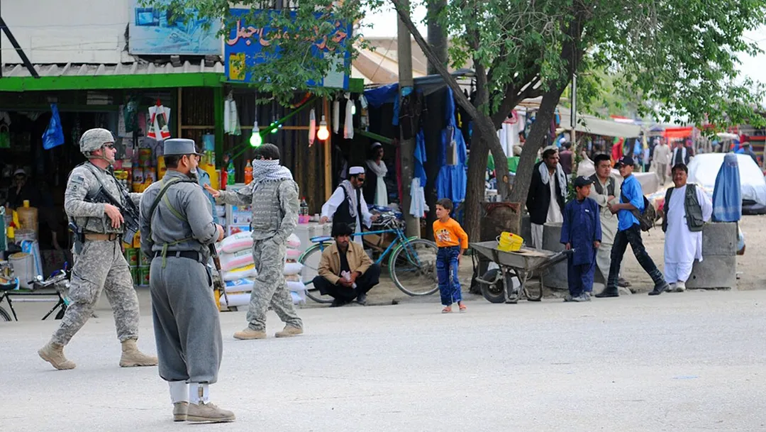
PARWAN PROVINCE, Afghanistan –U.S. Army Master Sgt. Donald Demar, non-commissioned officer in charge of Operational Coordination Center – Provincial, pulls security next to an Afghan National Police Officer on the street in Charikar outside the midwife academy, April 10. The ANP were in charge of security for a joint security effort with the Afghan National Army and U.S. Soldiers attached to the 1st Squadron, 172st Cavalry Regiment, 86th Infantry Brigade Combat Team at a graduation for 29 midwives, April 10.  (Photos by U.S. Army Staff Sgt. Whitney Hughes, Task Force Wolverine Public Affairs)
パンジシール渓谷の入り口であるパルヴァーン州のチャーリーカールの様子
An Afghan child poses for a photo as women work in a field in the Charikar district, Parwan province, Afghanistan, Jan. 3, 2012.
Photo by Whitney Hughes via ISAF Headquarters Public Affairs Office from Kabul, Afghanistan
Destinations
Home›Destinations›Charikar
AsiaAfghanistanParwan

Charikar

Parwan, Afghanistan · Asia

About Charikar

Charikar sits on the route: 15 minutes from Ghulām ‘Alī, 36km from Salang Pass.

Charikar is in Parwan, Afghanistan, with about 54,000 people. The nearest town is Ghulām ‘Alī, about 9 km away.

Charikar, also known as Imam Abu Hanifa or Imam Azam, is a city in the northeastern area of Afghanistan, serving as the capital of Parwan Province. It is within the jurisdiction of Charikar District and has an estimated population of 222,751 people. They include various ethnic groups of Afghanistan. The mayor of the

Read more city is Hafiz Raz Mohammad Yasir. Charikar was officially renamed in December 2022 to honor the 8th-century Sunni Muslim theologian and jurist Abu Hanifa, who is also sometimes called Imam Azam ("The Great Imam") and was the founder of the Hanafi school of Islamic law. The city lies on the Afghanistan Ring Road, 69 km (43 mi) from Kabul along the route to the northern provinces. Travelers would pass the city when traveling to Mazar-i-Sharif, Kunduz or Puli Khumri. Despite the proximity to Kabul, slightly more than half of the land is not built-up. Of the built-up land, almost equal parts are residential (37%) and vacant plots (32%), with a grid network of road coverage amounting to 19% of built-up land area, as of 2015. The city is at the gateway to the Panjshir Valley, where the Shamali plains meet the foothills of the Hindu Kush, and is known for its pottery and high-quality grapes. It has four police districts (nahias) and a total land area of 3,025 ha (11.68 sq mi).

Read more on Wikipedia

Where to Stay in Charikar

Compare prices across Booking.com, Airbnb, Expedia, and more. Select your dates to see availability.

Filter presets

Pick your must-haves once: provider links open pre-filtered. Each filter lists which sites it applies to.

Booking.comExpediaTripAdvisorHotels.comAgodaAirbnb

Compare before you book!

Prices can vary significantly between platforms. We recommend checking at least 2-3 sites to find the best deal for your stay in Charikar.

Explore the Area

Discover famous landmarks, scenic roads, and more near Charikar.

Loading map...
Open in Google Maps

Frequently Asked Questions

What is there to see near Charikar?

Within an hour or so of Charikar: Salang Pass (36 km).

Where is Charikar?

Charikar is in Parwan, Afghanistan, about 9 km from Ghulām ‘Alī.

Road trip

Drive to Charikar

Add it as a stop and the planner works out the driving, the nights and what's worth seeing on the way.

Start planning

What's nearby?

Swipe through places to go

Places within a drive of Charikar. Keep the ones you like and add them to your trip.

Explore now

Quick Information

Population
53,676
Continent
Asia
Country
Afghanistan
Region
Parwan
Timezone
Asia/Kabul
Coordinates
35.0136, 69.1714

Tags

AsiaAfghanistanParwanTown

Worth the detour from Charikar

1 notable place within an hour's drive.

tunnel

Salang Pass

The 2.7 km Salang Tunnel bores under the Hindu Kush at 3,400 m, a Soviet-built 1964 feat that is Afghanistan's only year-round road link between Kabul and the north. Approach roads climb through avalanche galleries and hairpins.

36 km · about 40 min drive

Driving roads near Charikar

  • 36 kmSalang PassThe 2.7 km Salang Tunnel bores under the Hindu Kush at 3,400 m, a Soviet-built 1964 feat that is Afghanistan's only year-round road link between Kabul and the north. Approach roads climb through avalanche galleries and hairpins.

Nearby Destinations

Other places to explore near Charikar.

Istālif

🇦🇫 Afghanistan

22 km awayPop. 41,413

Bāzārak

🇦🇫 Afghanistan

46 km awayPop. 65,000

Kabul

🇦🇫 Afghanistan

54 km awayPop. 4,434,550

Plan a trip around Charikar

Asia road trip planner

Your trip starts here

Plan a road trip from Charikar.

Pick the days, drop in the stops, and share it with whoever's coming.

Start planning
PYRT

The ultimate road trip planning platform. Discover 150,000+ destinations worldwide, plan scenic routes, and create unforgettable adventures.

Inspiration

  • Discover Trips
  • Travel Guides
  • Community

The Product

  • Calendar Planner
  • Integrations
  • How It Works
  • Collaboration Mode
  • Get the App
  • Merchandise: PYRT Supply Co.
  • Become a Creator
  • Trip Marketplace

Plan Your Trip

  • Road Trip Planner
  • Famous Routes
  • Drive Times & Distances
  • Planners by Country
  • Best Road Trip Planner App
  • Discover Road Trips
  • Events
  • Travel Guides
  • How It Works
  • My Trips
  • Community Groups

Company

  • Terms of Service
  • Privacy Policy
  • About PYRT
  • Support
  • Contact Us
  • Sign In
  • Create Account

© 2026 Plan Your Road Trips. All rights reserved.

•[email protected]
Data sources:GeoNames (CC BY 4.0)•Wikimedia Commons (CC BY-SA)•Mapbox•Photography: George Lawrence