PYRTPlan Your Road Trips
Create TripCommunityMerchandise
PYRTPlan Your Road Trips
Create TripCommunityMerchandise
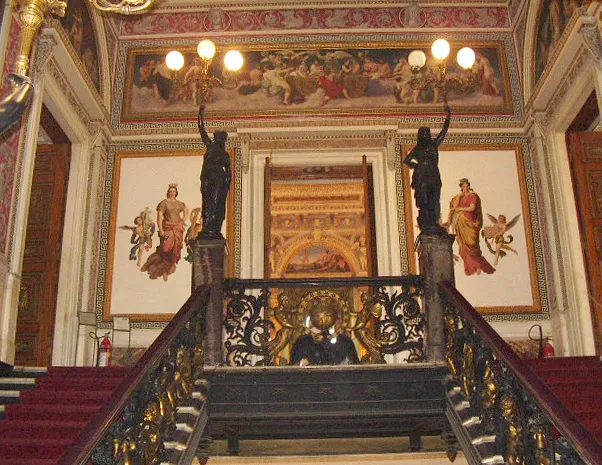
Interior of the Palácio do Catete in Rio de Janeiro, Brazil
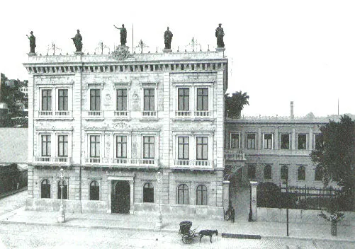
Catete Palace, 1897, Rio de Janeiro, Brazil
Óleo sobre tela, Emil Bauch, séc. XIX Acervo do IHGB/RJ (em comodato no Museu da República)
Photo by Redshipper [2], modified by Fulviusbsas
Destinations
Home›Destinations›Catete
South AmericaBrazilRio de Janeiro

Catete

Rio de Janeiro, Brazil · South America

About Catete

Catete works well as a base: 5 minutes from Santo Cristo, 1km from Escadaria Selaron.

Catete is in Rio de Janeiro, Brazil, with about 22,000 people. You drive on the right here. The nearest town is Santo Cristo, about 4 km away.

Where to Stay in Catete

Compare prices across Booking.com, Airbnb, Expedia, and more. Select your dates to see availability.

Filter presets

Pick your must-haves once: provider links open pre-filtered. Each filter lists which sites it applies to.

Booking.comExpediaTripAdvisorHotels.comAgodaAirbnb

Compare before you book!

Prices can vary significantly between platforms. We recommend checking at least 2-3 sites to find the best deal for your stay in Catete.

Explore the Area

Discover famous landmarks, scenic roads, and more near Catete.

Loading map...
Open in Google Maps

Frequently Asked Questions

What is there to see near Catete?

Within an hour or so of Catete: Escadaria Selaron (1 km), Confeitaria Colombo (2 km), Rebouças Tunnel (3 km), Museu do Amanhã (3 km).

Where is Catete?

Catete is in Rio de Janeiro, Brazil, about 4 km from Santo Cristo.

Road trip

Drive to Catete

Add it as a stop and the planner works out the driving, the nights and what's worth seeing on the way.

Start planning

What's nearby?

Swipe through places to go

Places within a drive of Catete. Keep the ones you like and add them to your trip.

Explore now

Quick Information

Population
22,295
Continent
South America
Country
Brazil
Region
Rio de Janeiro
Timezone
America/Sao_Paulo
Coordinates
-22.9254, -43.1814

Emergency & Services

Essential numbers in Brazil

Police
190
Ambulance
192
Fire
193
Driving side
right
Full driving guide for Brazil

Tags

South AmericaBrazilRio de JaneiroTown

Worth the detour from Catete

8 notable places within an hour's drive.

photogenic

Escadaria Selaron

A staircase between Lapa and Santa Teresa covered by Chilean artist Jorge Selaron in over 2,000 tiles sent from 60 countries, worked on daily from 1990 until his death in 2013.

1 km · about 5 min drive

cafe

Confeitaria Colombo

An 1894 Rio patisserie of Belgian mirrors, Portuguese tiles and jacaranda cabinets, built when the city was flush with coffee money and still serving pastel de nata under a vast stained-glass skylight.

2 km · about 5 min drive

tunnel

Rebouças Tunnel

Twin-bore road tunnel under the Tijuca massif linking Rio's South Zone to the North Zone, about 2.8 kilometres long.

3 km · about 5 min drive

museum

Museu do Amanhã

Science museum by Santiago Calatrava on Rio's revitalised Praça Mauá waterfront, adjacent to the port district drive.

3 km · about 5 min drive

scenic viewpoint

Sugarloaf Mountain (Pão de Açúcar)

A granite peak rising 396 meters from Guanabara Bay, reached by cable car with sweeping views of Rio's beaches, mountains, and cityscape.

4 km · about 5 min drive

landmark

Christ the Redeemer

Towering 30-metre Art Deco statue of Jesus Christ atop Corcovado mountain overlooking Rio de Janeiro.

4 km · about 10 min drive

beach

Copacabana Beach

Rio de Janeiro's legendary four-kilometre stretch of sand framed by dramatic mountains and buzzing with energy.

5 km · about 10 min drive

bridge

Rio-Niterói Bridge

13 km box-girder giant striding across Guanabara Bay: the longest bridge in the Southern Hemisphere at its opening in 1974, with sweeping views of Rio's skyline.

6 km · about 10 min drive

Driving roads near Catete

  • Right hereRebouças TunnelTwin-bore road tunnel under the Tijuca massif linking Rio's South Zone to the North Zone, about 2.8 kilometres long.
  • Right hereSugarloaf Mountain (Pão de Açúcar)A granite peak rising 396 meters from Guanabara Bay, reached by cable car with sweeping views of Rio's beaches, mountains, and cityscape.
  • Right hereRio-Niterói Bridge13 km box-girder giant striding across Guanabara Bay: the longest bridge in the Southern Hemisphere at its opening in 1974, with sweeping views of Rio's skyline.
  • Right hereVista ChinesaA pagoda-style belvedere built in 1903 in the Tijuca forest, giving a framed view over the Lagoa, Corcovado, Ipanema and Sugarloaf. Reachable by car on the Estrada da Vista Chinesa.

When to drive here

Year-round

Tropical latitude: plan around the wet season rather than temperature.

Nearby Destinations

Other places to explore near Catete.

Santa Teresa

🇧🇷 Brazil

1 km awayPop. 35,873

Rio de Janeiro

🇧🇷 Brazil

2 km awayPop. 6,747,815

Estácio

🇧🇷 Brazil

2 km awayPop. 23,260

Saúde

🇧🇷 Brazil

3 km awayPop. 1,876

Gamboa

🇧🇷 Brazil

3 km awayPop. 11,416

Santo Cristo

🇧🇷 Brazil

4 km awayPop. 9,936

Leme

🇧🇷 Brazil

4 km awayPop. 12,479

Ipanema

🇧🇷 Brazil

7 km awayPop. 37,392

Your trip starts here

Plan a road trip from Catete.

Pick the days, drop in the stops, and share it with whoever's coming.

Start planning
PYRT

The ultimate road trip planning platform. Discover 150,000+ destinations worldwide, plan scenic routes, and create unforgettable adventures.

Inspiration

  • Discover Trips
  • Travel Guides
  • Community

The Product

  • Calendar Planner
  • Integrations
  • How It Works
  • Collaboration Mode
  • Get the App
  • Merchandise: PYRT Supply Co.
  • Become a Creator
  • Trip Marketplace

Plan Your Trip

  • Road Trip Planner
  • Famous Routes
  • Drive Times & Distances
  • Planners by Country
  • Best Road Trip Planner App
  • Discover Road Trips
  • Events
  • Travel Guides
  • How It Works
  • My Trips
  • Community Groups

Company

  • Terms of Service
  • Privacy Policy
  • About PYRT
  • Support
  • Contact Us
  • Sign In
  • Create Account

© 2026 Plan Your Road Trips. All rights reserved.

•[email protected]
Data sources:GeoNames (CC BY 4.0)•Wikimedia Commons (CC BY-SA)•Mapbox•Photography: George Lawrence