PYRTPlan Your Road Trips
Create TripCommunityMerchandise
PYRTPlan Your Road Trips
Create TripCommunityMerchandise
Ardrossan's fan club.
Photo of Bryn
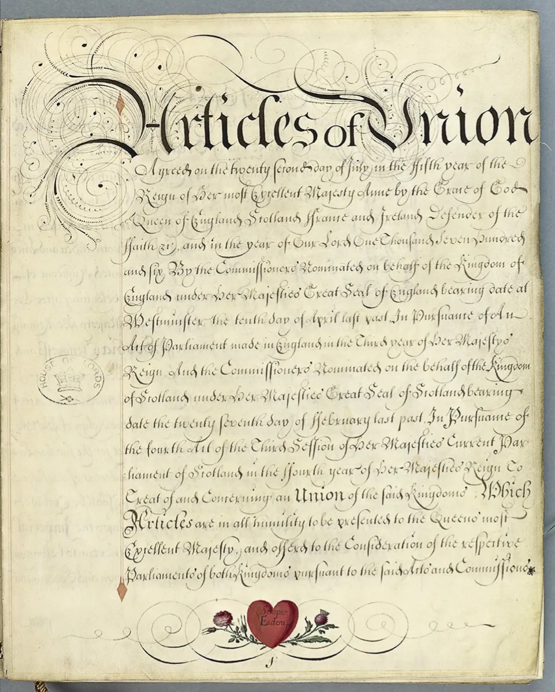
This file comprises a vellum-bound volume containing the Articles of Union agreed by the Commissioners nominated by Queen Anne in 1706. The Articles are signed and sealed by the Commissioners, those of England signing in the right hand columns and those for Scotland in the left. The first two English signatures are of the Archbishop of Canterbury and William Cowper, Keeper of the Great Seal, whilst the first two Scottish signatures are of the Scottish Chancellor, Lord Sealfield, and the Duke of Queensbury, the Scottish Lord Privy Seal.
Annexed:
a) 28 Jan -- Copy of Act ratifying and approving the treaty of Union of the two Kingdoms of Scotland and England as passed by the Scottish Parliament [now in HL/PO/JO/10/2/28].
b) 28 Jan -- Volume bound in vellum containing the Minutes of the Proceedings of the English and Scottish Commissioners who drew up the Articles of Union [now in HL/PO/JO/10/2/28].

c) 18 Feb -- Copy of Act settling the manner of electing the sixteen Peers and forty-five members to represent Scotland in the Parliament of Great Britain, as passed by the Scottish Parliament [now in HL/PO/JO/10/2/28].
Photo by grumpylumixuser
Destinations
Home›Destinations›Bryn
EuropeUnited KingdomWales

Bryn

Wales, United Kingdom · Europe

About Bryn

Bryn works well as a base: 5 minutes from Maesteg, 20km from Nedd Fechan Gorge.

Bryn is in Wales, United Kingdom, with about 923 people. You drive on the left here. The nearest town is Maesteg, about 4 km away.

Bryn (Welsh for 'hill') is a village and community in Neath Port Talbot County Borough in Wales. It has a population of 913. The village is located in the hills between Cwmafan, in the Afan Valley, and Maesteg in the Llynfi Valley, approximately 6 miles (9.7 km) from Port Talbot and 2 miles (3.2 km) from Maesteg. The

Read more name of the village now familiarly 'Bryn', is Bryn-troed-y-garn. So wrote the first vicar of St Theodore's in Port Talbot. There was a farm situated above Meadow Row named Bryn-Troed-y-Garn as shown on the 1876 OS map, as many more immigrants came to 'Bryn-troed-y-garn' it seemed the name of the village was to be shorted to Bryn. 12% of the village (112 out of 913 people) speak Welsh. The population rose to 923 by 2011.

Read more on Wikipedia

Where to Stay in Bryn

Compare prices across Booking.com, Airbnb, Expedia, and more. Select your dates to see availability.

Filter presets

Pick your must-haves once: provider links open pre-filtered. Each filter lists which sites it applies to.

Booking.comExpediaTripAdvisorHotels.comAgodaAirbnb

Compare before you book!

Prices can vary significantly between platforms. We recommend checking at least 2-3 sites to find the best deal for your stay in Bryn.

Explore the Area

Discover famous landmarks, scenic roads, and more near Bryn.

Loading map...
Open in Google Maps

Frequently Asked Questions

What is there to see near Bryn?

Within an hour or so of Bryn: Melincourt Falls (10 km), Sgwd Gwladys (Lady Falls) (19 km), Sgwd yr Eira (20 km), Henrhyd Falls (20 km).

Are there any good drives near Bryn?

The nearest famous roads are Black Mountain Pass (A4069), Countisbury Hill and Porlock Hill.

Where is Bryn?

Bryn is in Wales, United Kingdom, about 4 km from Maesteg.

Road trip

Drive to Bryn

Add it as a stop and the planner works out the driving, the nights and what's worth seeing on the way.

Start planning

What's nearby?

Swipe through places to go

Places within a drive of Bryn. Keep the ones you like and add them to your trip.

Explore now

Quick Information

Population
923
Continent
Europe
Country
United Kingdom
Region
Wales
Timezone
Europe/London
Coordinates
51.6164, -3.7117

Emergency & Services

Essential numbers in United Kingdom

Police
999
Ambulance
999
Fire
999
Non-emergency police
101
Driving side
left

112 also works. NHS non-emergency medical advice: 111. National Highways breakdown assistance on motorways: 0300 123 5000.

Full driving guide for United Kingdom

Tags

EuropeUnited KingdomWalesTown

Worth the detour from Bryn

8 notable places within an hour's drive.

waterfall

Melincourt Falls

An 24m fall in the Neath Valley painted by Turner in 1795, reached by a short riverside path.

10 km · about 20 min drive

waterfall

Sgwd Gwladys (Lady Falls)

A graceful fall on the Afon Pyrddin near Pontneddfechan, also walkable behind, in the heart of Waterfall Country.

19 km · about 20 min drive

waterfall

Sgwd yr Eira

Spectacular waterfall in the Brecon Beacons where you can walk behind the curtain of water on a natural rock ledge, a truly unique experience.

20 km · about 25 min drive

waterfall

Henrhyd Falls

At 27m the highest waterfall in south Wales, and the Batcave entrance in The Dark Knight Rises; reached by a steep wooded path.

20 km · about 25 min drive

natural wonder

Nedd Fechan Gorge

A limestone river gorge threaded with falls and caves between Pontneddfechan and Ystradfellte, the spine of Waterfall Country.

20 km · about 25 min drive

waterfall

Sgwd Clun-Gwyn

The first of the Four Waterfalls on the Afon Mellte, a wide stepped fall in the limestone gorge near Ystradfellte.

22 km · about 25 min drive

famous road

Black Mountain Pass (A4069)

Top Gear's favourite British road, a smooth, empty ribbon of hairpins and open bends over the western Brecon Beacons between Llangadog and Brynamman.

27 km · about 30 min drive

beach

Three Cliffs Bay

Triple limestone peaks guard a sweep of sand where Pennard Pill meanders to the sea on the Gower: repeatedly voted among Britain's best beaches yet reached only on foot past a ruined castle. View from Pennard cliffs is the classic.

28 km · about 35 min drive

Driving roads near Bryn

  • 27 kmBlack Mountain Pass (A4069)Top Gear's favourite British road, a smooth, empty ribbon of hairpins and open bends over the western Brecon Beacons between Llangadog and Brynamman.
  • 35 kmPen y FanThe highest peak in southern Britain at 886 metres, the flat-topped summit of the Brecon Beacons offering sweeping views across Wales.
  • 35 kmCorn DuPen y Fan's twin summit at 873m, with a Bronze Age cairn and the finest view over the Beacons' north escarpment.
  • 43 kmCountisbury HillA long 1-in-4 climb on the A39 out of Lynmouth onto Exmoor, with sweeping views over the Bristol Channel.
  • 46 kmPorlock HillBritain's steepest A-road, where the A39 climbs out of Porlock onto Exmoor at gradients up to 1-in-4 with two severe hairpins. A scenic Victorian toll road offers a gentler coastal alternative.
  • 47 kmPorlock Hill (A39)One of England's steepest A-roads at 1-in-4 with hairpins out of Porlock onto Exmoor; a toll road offers a gentler alternative.

Driving in United Kingdom

Drives on
the left
Petrol
~€1.73/litre
Motorway tolls
None

When to drive here

April to October

Nearby Destinations

Other places to explore near Bryn.

Cwmafan

🇬🇧 United Kingdom

3 km awayPop. 5,336

Maesteg

🇬🇧 United Kingdom

4 km awayPop. 21,001

Briton Ferry

🇬🇧 United Kingdom

8 km awayPop. 35,179

Neath

🇬🇧 United Kingdom

8 km awayPop. 46,126

Glyncorrwg

🇬🇧 United Kingdom

9 km awayPop. 1,096

Pyle

🇬🇧 United Kingdom

11 km awayPop. 13,701

Clydach

🇬🇧 United Kingdom

15 km awayPop. 19,307

Treorchy

🇬🇧 United Kingdom

15 km awayPop. 8,105

Plan a trip around Bryn

Wales road trip planner

Your trip starts here

Plan a road trip from Bryn.

Pick the days, drop in the stops, and share it with whoever's coming.

Start planning
PYRT

The ultimate road trip planning platform. Discover 150,000+ destinations worldwide, plan scenic routes, and create unforgettable adventures.

Inspiration

  • Discover Trips
  • Travel Guides
  • Community

The Product

  • Calendar Planner
  • Integrations
  • How It Works
  • Collaboration Mode
  • Get the App
  • Merchandise: PYRT Supply Co.
  • Become a Creator
  • Trip Marketplace

Plan Your Trip

  • Road Trip Planner
  • Famous Routes
  • Drive Times & Distances
  • Planners by Country
  • Best Road Trip Planner App
  • Discover Road Trips
  • Events
  • Travel Guides
  • How It Works
  • My Trips
  • Community Groups

Company

  • Terms of Service
  • Privacy Policy
  • About PYRT
  • Support
  • Contact Us
  • Sign In
  • Create Account

© 2026 Plan Your Road Trips. All rights reserved.

•[email protected]
Data sources:GeoNames (CC BY 4.0)•Wikimedia Commons (CC BY-SA)•Mapbox•Photography: George Lawrence